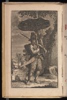
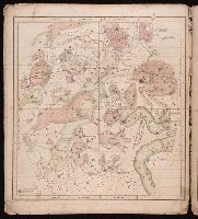
Anno a Christi natiuitate 1525. Tertio Kal'. Apriles.
Call Number:
1976 +325
Image Count:
1
Resource Type:
Books, Journals & Pamphlets
Description:
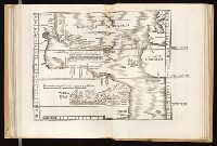
Each map is printed across two leaves of plates. Maps 1 to 49 are numbered and have text on recto of initial leaf; final map is unnumbered, has no text on recto of initial leaf., Imprint information from colophon (leaf Q8 recto)., Index ([68] p., third group) bound at end, after maps., Signatures: A-M⁶ N⁴ 0-P⁶ Q⁸ a-e⁶ f⁴., and Variant order of binding: index precedes maps. Autograph of Giovanni Battista Francino.
Publisher:
Iohannes Grieningerus, communibus Iohannis Koberger impensis excudebat,
Subject (Name):
Francino, Giovanni Battista,--1631-1698--Autograph. and Regiomontanus, Joannes, 1436-1476.
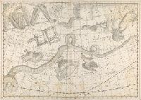
All volumes bound to match 1973 Folio 72. Factitious collection of about 549 maps taken from the atlases of the 17th and the beginning of the 18th cent., put together with the title "Atlas" and bound in 6 volumes. These volumes originally bore the imprint: Amstelaedamii apvd Reiniervm & Josvam Ottens. Over these words on the title-pages of v. 1-2, 4-6 is the name of Henrik de Leth who painted them. Volume 3 has only the erased imprint of Ottens., For fuller description see Phillips 3448 and C. Koeman's Atlantes Neerlandici, bibliography of terrestrial, maritime and celestial atlases and pilot books, published in the Netherlands up to 1800, Amsterdam c1967-71, v. 2, p. 63-83., and Maps by P. Schenck and son, G. Valck, F. de Wit, N. Visscher and others.
Publisher:
chez J. Covens & C. Mortier,
Subject (Geographic):
Denmark --Maps --Early works to 1800
Subject (Name):
Reiner et Josua Ottens (Firm), Schenk, Peter, 1660-1718 or 1719., and Valck, G. (Gerard), 1651 or 1652-1726.
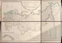
Pi︠a︡dyshev, Vasiliĭ Petrovich, 1768-1835. Пядышев, Василий Петрович, 1768-1835.
Published / Created:
1820-1827.
Call Number:
EEdb 828P
Image Count:
1
Resource Type:
Maps, Atlases & Globes
Alternative Title:
Atlas géographique de l'empire de Russie, du royaume de Pologne and du grand duché de Finlande and Географическій атлас Россійской Имперіи Царства Польскаго и Великаго Княжества Финляндскаго : расположенный по губерніям на 80 листах ... с генеральною картою ... / сочинен по новѣйшим и достовѣрным свѣденіям ... Пядышевым, начат 1820-го, окончен 1827-го года = Atlas géographique de l'empire de Russie, du royaume de Pologne et du grand duché de Finlande ; divisé en gouvernements ... ; avec une carte générale ... / composé ... par ... Pi︠a︡discheff ...
Description:
Captions and place names in Russian and Polish or in Russian and French., Relief shown by spot heights., and Some maps composed of two or more leaves hinged with cloth.
Publisher:
[publisher not identified],
Subject (Geographic):
Soviet Union.--(OCoLC)fst01210281 and Soviet Union--Maps.
Cover title. and Original wrappers. Autograph on 2nd map: E.J. Bullock. Ms. annotations on wrapper. From the Kurt Seligmann Papers.
Publisher:
Huntington and Savage,
Subject (Name):
Berton, H. P.--Autograph., Bullock, E. J.--Autograph., Rodman, Sophia M. Loomis--Autograph., Sage & Brother, bookseller, and Seligmann, Kurt,--1900-1962--Ownership.