Skip to search
Skip to main content
Skip to first result
Search
You Searched For
Resource Type
Maps, Atlases & Globes
Publication Place
New York :
New Search
Search Results
Creator:
Published / Created:
[1918?]
Call Number:
11hcf 1919-14
Container / Volume:
BRBL_00010J
Image Count:
1
Resource Type:
Maps, Atlases & Globes
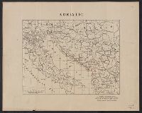
Description:
Ms. notes showing Italian land claims following World War I.
Publisher:
American Geographical Society,
Subject (Geographic):
Adriatic Sea Region--Maps
Subject (Topic):
World War, 1914-1918--Maps
Found in:
Beinecke Rare Book and Manuscript Library > Adriatic [Sea region].
Creator:
Published / Created:
c1914.
Call Number:
30am 1914
Container / Volume:
BRBL_00037
Image Count:
1
Resource Type:
Maps, Atlases & Globes
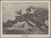
Alternative Title:
Literary digest (New York, N.Y. : 1890)
Description:
"Copyright 1914-E.W. Spofford ... New York.", Panorama as if from outer space., Relief shown by shading., and Removed from the Francis LeJau Parker papers in LC Manuscript Division.
Publisher:
Literary digest,
Subject (Geographic):
Europe--Aerial views
Found in:
Beinecke Rare Book and Manuscript Library > Aero view of Europe / [drawn by] Spofford, N.Y.
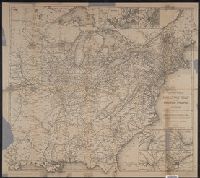
Creator:
Published / Created:
[1864]
Call Number:
75gme 1864
Container / Volume:
BRBL_00412
Image Count:
2
Resource Type:
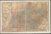
Maps, Atlases & Globes
Alternative Title:
Railway map of the United States and the Canadas
Description:
Advertisements and ancillary map: Map of Illinois Central Railway and connections, on verso., Inset: [Western United States]., Prime meridian: Washington, D.C., and Relief shown by hachures.
Publisher:
D. Appleton & Co.,
Subject (Name):
D. Appleton and Company
Subject (Topic):
Railroads--United States--Maps
Found in:
Beinecke Rare Book and Manuscript Library > Appletons' railway map of the United States and the Canadas : representing railways in actual operation, and those in course of construction, also map of the territories, showing the Pacific Railroad, gold regions, &c. / carefully compiled by G. F. Thomas
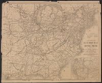
Creator:
Published / Created:
[1876]
Call Number:
754gme 1876
Container / Volume:
BRBL_00420
Image Count:
2
Resource Type:
Maps, Atlases & Globes
Alternative Title:
Railway map of the United States and the Canadas
Description:
"Engraved by Rae Smith, N.Y.", Inset maps of Baltimore, New York, Boston, St. Louis, Chicago, Cincinnati, and Philadelphia., On verso: adv. and ill., and Prime meridian: Washington, D.C.
Publisher:
D. Appleton & Co.,
Subject (Name):
D. Appleton and Company
Subject (Topic):
Railroads--United States--Maps
Found in:
Beinecke Rare Book and Manuscript Library > Appletons' railway map of the United States and the Canadas : representing railways in actual operation, and those in course of construction, also map of the territories, showing the Pacific Railroad, gold regions, &c. / carefully compiled by G. F. Thomas
Creator:
Published / Created:
[1914?]
Call Number:
11hcf 1919B-13
Container / Volume:
BRBL_00010O
Image Count:
3
Resource Type:
Maps, Atlases & Globes
Description:
Sheet 2 fragile, in 3 fragments.
Publisher:
American Geographical Society,
Subject (Geographic):
Austria--Maps and Europe, Eastern--Maps
Found in:
Beinecke Rare Book and Manuscript Library > Austria-Hungary [cartographic material].
Branch:v1.64.0 ,Deployed:2024-09-11T10:25:35-04:00