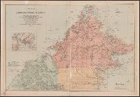
Covers Brunei, Sabah, and northern Sarawak., Includes inset location map., Land available for sale or sold indicated., Library copy accompanied by manuscript notes., and Relief shown by hachures and spot heights. Soundings in fathoms.
Publisher:
Published by Edward Stanford for the British North Borneo Company,
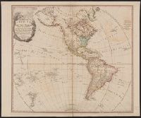
Anville, Jean Baptiste Bourguignon d', 1697-1782 Chapman, Thomas, fl. 1790-1803 Neele, Samuel John, 1758-1824, engraver Pauw, Cornelius, 1739-1799. Philosophical dissertations on the Egyptians and Chinese
Published / Created:
Jany. 1st, 1795.
Call Number:
1977 Folio 177
Image Count:
2
Resource Type:
Maps, Atlases & Globes
Description:
"Neele, sculpt.", Ms. note at head of title: De Pauw. Sheet measures 50.7 x 63.8 cm. No. 15 of 34 maps bound together., Prime meridians: Ferro., Relief shown pictorially., and Watermark.
Map of China showing the stations of the China Inland Mission
Description:
"China Inland Mission stations with resident missionary are underlined in red.", "Stanford's Geog! Estab., London.", and Covers on verso not digitized.