Skip to search
Skip to main content
Skip to first result
Search
You Searched For
Format
cartographic
New Search
Search Results
Creator:
Published / Created:
c1910.
Call Number:
848 W684 1910
Container / Volume:
BRBL_00634
Image Count:
1
Resource Type:
Maps, Atlases & Globes
Alternative Title:
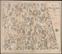
Willow Creek Mining District, Cook Inlet Precinct, Alaska
Description:
Includes key with lode claims locations of specific mining companies. and Relief shown by hachures and spot heights.
Publisher:
Rand McNally & Co.,
Subject (Geographic):
Alaska--Maps, Knik Arm (Alaska)--Maps, Susitna River (Alaska)--Maps, and Willow Creek (Alaska)--Maps
Subject (Topic):
Gold mines and mining--Alaska--Willow Creek--Maps and Mines and mineral resources--Alaska--Willow Creek--Maps
Found in:
Beinecke Rare Book and Manuscript Library > Map of Willow Creek Mining District, Cook Inlet Precinct, Alaska / compiled ... by D.H. Sleem.
Creator:
Published / Created:
[1873?]
Call Number:
BrSides 2018 157
Image Count:
1
Resource Type:
Maps, Atlases & Globes
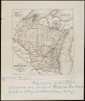
Description:
"County lines in red lines.", Manuscript annotations showing location of mines discovered and opened on Menomonee Iron Range and line of projected narrow gauge railway. From the Richard H. Rickard Papers., Prime meridian: Greenwich., and Shows cities, counties, railroads completed, and railroads projected.
Publisher:
Milwaukee Lith. & Eng. Co.,
Subject (Geographic):
Wisconsin and Wisconsin--Maps
Subject (Name):
Rickard, Richard H.,---1885--Ownership.
Found in:
Beinecke Rare Book and Manuscript Library > Map of Wisconsin : prepared for the legislative manual from offical records, 1873.
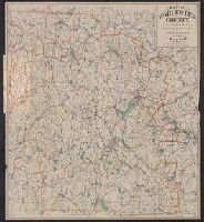
Creator:
Published / Created:
c1906.
Call Number:
812 1906
Container / Volume:
BRBL_00555A
Image Count:
1
Resource Type:
Maps, Atlases & Globes
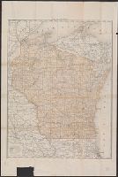
Description:
Imperfect. Chipped with no loss of text. and Prime meridians: Greenwich and Washington.
Publisher:
Poole Bros.,
Subject (Geographic):
Wisconsin--Maps
Subject (Topic):
Railroads--Wisconsin--Maps
Found in:
Beinecke Rare Book and Manuscript Library > Map of Wisconsin.
Published / Created:
1889?]
Call Number:
846 W867 1889
Container / Volume:
BRBL_00622
Image Count:
2
Resource Type:
Maps, Atlases & Globes
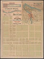
Alternative Title:
Map and description of Woodstock
Description:
Date inferred from list of property prices, dated Dec. 12, 1889, attached to verso., Includes inset of "City of Portland, East Portland, surroundings, and railroad connections.", Shows numbered lots., and Text on verso.
Publisher:
Telfer & Stearns?,
Subject (Geographic):
Woodstock (Or.)--Maps
Subject (Name):
Havely, J. C, Lewis & Dryden Printing Company, and Telfer & Stearns Real Estate Co
Subject (Topic):
Real property--Oregon--Woodstock--Maps
Found in:
Beinecke Rare Book and Manuscript Library > Map of Woodstock : the eastern terminus of the Waverly-Woodstock Electric motor line / J.C. Havely, trustee ; Telfer & Stearns Real Estate Co., general agents.
Creator:
Published / Created:
[1886]
Call Number:
766 W86 1886
Container / Volume:
BRBL_00474
Image Count:
1
Resource Type:
Maps, Atlases & Globes
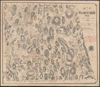
Description:
Relief shown by hachures.
Publisher:
Heliotype Printing Company
Subject (Geographic):
Woodstock (Conn.)--Maps
Subject (Name):
Heliotype Printing Company and Williams, George Clinton
Found in:
Beinecke Rare Book and Manuscript Library > Map of Woodstock, Conn., 1883. Topographical & historical names, added by Geo. Clinton Williams, 1886.
Creator:
Published / Created:
[1886]
Call Number:
766 W86 1886
Container / Volume:
BRBL_00474
Image Count:
1
Resource Type:
Maps, Atlases & Globes
Description:
Relief shown by hachures.
Publisher:
Heliotype Printing Company
Subject (Geographic):
Woodstock (Conn.)--Maps
Subject (Name):
Heliotype Printing Company and Williams, George Clinton
Found in:
Beinecke Rare Book and Manuscript Library > Map of Woodstock, Conn., 1883. Topographical & historical names, added by Geo. Clinton Williams, 1886.
Published / Created:
1832
Call Number:
763 W86 1832
Container / Volume:
BRBL_00452
Image Count:
1
Resource Type:
Maps, Atlases & Globes
Publisher:
Pendleton's Lithography,
Found in:
Beinecke Rare Book and Manuscript Library > Map of Woodstock, Vt. Drawn by a Committee from the Woodstock Institute.
Creator:
Published / Created:
c1904.
Call Number:
764 W89 1904
Container / Volume:
BRBL_00460
Image Count:
1
Resource Type:
Maps, Atlases & Globes
Alternative Title:
Worcester County, Massachusetts
Description:
"Copyright 1892 & 1904"., Cover title: Worcester County, Massachusetts., and Cycling routes shown in red.
Publisher:
Geo. H. Walker & Co.,
Subject (Geographic):
Worcester County (Mass.)--Maps
Subject (Topic):
Cycling--Massachusetts--Worcester County--Maps
Found in:
Beinecke Rare Book and Manuscript Library > Map of Worcester County, Mass. / published by Geo. H. Walker & Co.
Published / Created:
1857
Call Number:
764 W89 1857
Container / Volume:
BRBL_00460
Image Count:
4
Resource Type:
Maps, Atlases & Globes
Description:
Shows landowners.
Publisher:
Wm. E. Baker & Co.,
Subject (Geographic):
Worcester (Mass.)--Maps
Found in:
Beinecke Rare Book and Manuscript Library > Map of Worcester county, Mass. ... from accurat surveys under the direction of Henry F. Walling ... 1857..
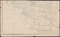
Creator:
Published / Created:
1882
Call Number:
847 Y12 1882
Container / Volume:
BRBL_00627
Image Count:
2
Resource Type:
Maps, Atlases & Globes
Alternative Title:
Map of Yakima Region, Washington Ter., western sheet
Description:
"Photolithographed preliminary sheet for the use of the parties in the field, and subject to revision.", In top margin: Western sheet., and Relief shown by contours and spot heights.
Publisher:
Northern Transcontinental Survey?],
Subject (Geographic):
Yakima River Valley (Wash.)--Maps, Topographic
Subject (Name):
Goode, Richard Urquhart, 1858-1903, Julius Bien & Co, Northern Transcontinental Survey, Owen, F. D, and Tweedy, Frank, 1854-1937
Found in:
Beinecke Rare Book and Manuscript Library > Map of Yakima Region, Washington Ter. / Northern Transcontinental Survey, Raphael Pumpelly, director ; A.D. Wilson, chief topographer ; R.U. Goode, topographer ; Frank Tweedy, Asst. ; F.D. Owen, chief draughtsman.
Branch:v1.61.6 ,Deployed:2024-06-12T09:55:33-04:00