Search
You Searched For
Search Results
- Creator:
- Maury, Matthew Fontaine, 1806-1873
- Published / Created:
- 1852-[1859?]
- Call Number:
- 11cfk 1850A-2
- Container / Volume:
- BRBL_00767
- Image Count:
- 4
- Resource Type:
- Maps, Atlases & Globes
- Found in:
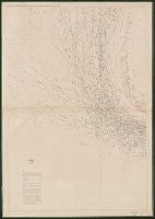
- Beinecke Rare Book and Manuscript Library > Maury's wind and current chart [cartographic material] : South Pacific / drawn by Lardner Gibbon, P.M. U.S.N.
- Creator:
- Maury, Matthew Fontaine, 1806-1873
- Published / Created:
- 1852-[1859?]
- Call Number:
- 11cfk 1850A-2
- Container / Volume:
- BRBL_00767
- Image Count:
- 1
- Resource Type:
- Maps, Atlases & Globes
- Found in:
- Beinecke Rare Book and Manuscript Library > Maury's wind and current chart [cartographic material] : South Pacific / drawn by Lardner Gibbon, P.M. U.S.N.
- Creator:
- Maury, Matthew Fontaine, 1806-1873
- Published / Created:
- [1854?]-1856.
- Call Number:
- 11cfk 1850A-5
- Container / Volume:
- BRBL_00769
- Image Count:
- 8
- Resource Type:
- Maps, Atlases & Globes
- Found in:
- Beinecke Rare Book and Manuscript Library > Maury's wind and current chart, Indian Ocean [cartographic material].
- Creator:
- Maury, Matthew Fontaine, 1806-1873
- Published / Created:
- 1859 [i.e. 1860]
- Call Number:
- 11cfk 1850B-2
- Container / Volume:
- BRBL_00770
- Image Count:
- 1
- Resource Type:
- Maps, Atlases & Globes
- Found in:
- Beinecke Rare Book and Manuscript Library > Monsoon & trade wind chart of the Indian Ocean [cartographic material] / by M.F. Maury, L.L.D. Comr. U.S.N., Superintendent of U.S.N. Observatory ; compiled by Lieuts. J.J. Guthrie ... [et al.] ; and projected by Lt. R.L. May from materials in the Bureau of Ordnance and Hydrography, Captain D.N. Ingraham, Chief of the Bureau.
- Creator:
- Maury, Matthew Fontaine, 1806-1873
- Published / Created:
- 1852
- Call Number:
- 11cfk 1850C-9
- Container / Volume:
- BRBL_00772
- Image Count:
- 2
- Resource Type:
- Maps, Atlases & Globes
- Found in:
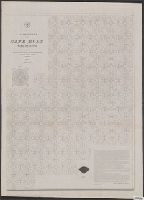
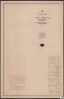
- Beinecke Rare Book and Manuscript Library > Pilot chart for Cape Horn [cartographic material] / by M.F. Maury, L.L.D. Lieut. U.S. Navy, Superin'dt. of U.S.N. Observatory ; compiled from materials in the Bureau of Ordnance and Hydrography, Commodore Charles Morris, Chief of Bureau.
- Creator:
- Maury, Matthew Fontaine, 1806-1873
- Published / Created:
- 1852
- Call Number:
- 11cfk 1850C-9
- Container / Volume:
- BRBL_00772
- Image Count:
- 2
- Resource Type:
- Maps, Atlases & Globes
- Found in:
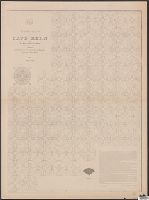
- Beinecke Rare Book and Manuscript Library > Pilot chart for Cape Horn [cartographic material] / by M.F. Maury, L.L.D. Lieut. U.S. Navy, Superin'dt. of U.S.N. Observatory ; compiled from materials in the Bureau of Ordnance and Hydrography, Commodore Charles Morris, Chief of Bureau.
- Creator:
- Maury, Matthew Fontaine, 1806-1873
- Published / Created:
- 1853 [i.e. 1857]
- Call Number:
- 11cfk 1850C-2
- Container / Volume:
- BRBL_00770
- Image Count:
- 2
- Resource Type:
- Maps, Atlases & Globes
- Found in:
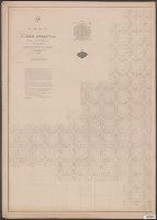
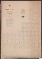
- Beinecke Rare Book and Manuscript Library > Pilot chart of the North Atlantic [cartographic material] / by M.F. Maury, L.L.D. Lieut. U.S. Navy ; superint'dt. of U.S.N. Observatory, Washington ; compiled from materials in the Bureau of Ordnance and Hydrography.
- Creator:
- Maury, Matthew Fontaine, 1806-1873
- Published / Created:
- 1849
- Call Number:
- 11cfk 1850C-1
- Container / Volume:
- BRBL_00770
- Image Count:
- 2
- Resource Type:
- Maps, Atlases & Globes
- Found in:
- Beinecke Rare Book and Manuscript Library > Pilot chart of the North Atlantic [cartographic material].
- Creator:
- Maury, Matthew Fontaine, 1806-1873
- Published / Created:
- 1852-1853.
- Call Number:
- 11cfk 1850C-5
- Container / Volume:
- BRBL_00771
- Image Count:
- 5
- Resource Type:
- Maps, Atlases & Globes
- Found in:
- Beinecke Rare Book and Manuscript Library > Pilot chart of the North Pacific [cartographic material] / by M.F. Maury, L.L.D. Lieut. U.S. Navy, superin'dt. of U.S.N. Observatory ; compiled from materials in the Bureau of Ordnance and Hydrography, Commodore Charles Morris, Chief of Bureau.