"Cum priuilegio.", Hand col. Sheet measures 47 x 57 cm., Includes text and ornamental cartouche., Latin, French., Pg. nos. on verso: 61, 64., Relief shown pictorially., Running title on verso: L'Afrique., and Signature on verso: Q.
Includes chart showing political divisions by region., On verso: 37., Prime meridians: Greenwich and Ferro., Relief shown pictorially., and Watermark: Whatman 1825.
Publisher:
Published ... by Robert Wilkinson, no. 125 Fenchurch Street : and Republished with additions and corrections by William Darton, 58 Holborn Hill,
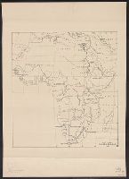
Boundaries hand colored., From Johnston's Royal atlas of modern geography?, Prime meridian: Greenwich., Relief shown by hachures., and Upper right: 36.
Subject (Geographic):
Africa--Maps
Subject (Name):
Johnston, Alexander Keith, 1804-1871. Royal atlas of modern geography and W. & A.K. Johnston Limited, publisher
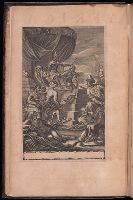
"A catalogue of the names of the general authors, both ancient and modern, besides later voyagers, consulted to the carrying on of this first volume": 7th prelim. leaf., Imperfect: 2 maps (Tunis and Lovando St. Paulo) wanting., In this Beinecke copy, the 1st prelimin. leaf bears text "English atlas, tome the first" and the "Catalog" is on the 8th prelim. leaf., and Title in red and black; intials; head-pieces.
Publisher:
Printed by T. Johnson for the author,
Subject (Geographic):
Africa--Description and travel, Islands of the Atlantic, and Islands of the Indian Ocean
Subject (Name):
Boynton, Griffith--Autograph and ms notes and Hodgdon, Ernest F.--Stamp
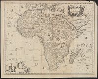
From Ogilby's Africa, being an accurate description of the regions of Egypt, Barbary, Lybia and Billedulgerid. 1670., Includes decorative title and blank dedication cartouches and ill., Relief shown pictorially., and Sheet measures 47 x 59 cm.
Publisher:
Printed by T. Johnson for the author [i.e. J. Ogilby],
Subject (Geographic):
Africa--Maps--Early works to 1800
Subject (Name):
Ogilby, John, 1600-1676. Africa, being an accurate description of the regions of Egypt, Barbary, Lybia and Billedulgerid