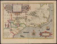
First appeared in Gerhard Mercator's atlas brought out by Jodocus Hondius beginning in 1606., Inc, Latin text on verso; with caption title "Virginia et Florida," signature 7Q, and catchword "Florida.", and Sheet measures 40.4 x 54.1 cm. Cross Collection no. 214.
Publisher:
Jodocus Hondius?,
Subject (Geographic):
Florida--Maps--Early works to 1800, South Atlantic States--Maps--Early works to 1800, and Virginia--Maps--Early works to 1800
Subject (Name):
Hondius, Jodocus, 1563-1612 and Mercator, Gerhard, 1512-1594. Atlas
Appears in French eds. of Gerhard Mercator's Atlas (1628 and 1635)., Includes notes, col. ill., and cartouche with a view of a Florida Indian village on the left and a Virginia Indian village on the right., Relief shown pictorially., and Sheet measure
Publisher:
Hendrik Hondius,
Subject (Geographic):
Florida--Maps--Early works to 1800, South Atlantic States--Maps--Early works to 1800, and Virginia--Maps--Early works to 1800
Subject (Name):
Hondius, Hendrik, 1597-1651 and Mercator, Gerhard, 1512-1594. Atlas. French
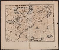
Prime meridian Ferro., Signature has been corrected in ms. to "G." Sheet measures 50.3 x 58.2 cm. Franklin 131 16, and Verso in German, with running and caption title "Die Insel Florida," paginated 29, signature 2E, and Hispanien at foot of 1st column on p. 29.
Publisher:
s.n.,
Subject (Geographic):
South Atlantic States--Maps--Early works to 1800
Subject (Name):
Blaeu, Willem Janszoon, 1571-1638. Theatrum orbis terrarum. German
Prime meridian Ferro., Relief shown pictorially., Sheet measures 50.8 x 59.2 cm. Cross Collection no. 212., Verso in French, with running and caption title "Floride," paginated 28, signature 2E, and Amerique at foot of 1st column on p. 28., and Watermark.
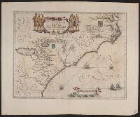
Appears in various, Hand col. Sheet measures 50 x 60.9 cm., Latin text on recto; Dutch text on verso., Prime meridian Ferro., Relief shown pictorially., and Verso in Dutch, with running and caption title "Florida," signature 2E and catchword "rivieren".
Maps numbered in manuscript 1 to 97; wanting 2, 42, 45, 51, 52, 74, 85, 89, 92 and 93., Some maps dated 1704-1717, others without date., Some maps first published in J. van Keulen's De nieuwe groote lichtende zee-fackel and G. van Keulen's De groote nieuwe vermeerderde zee-atlas., Title devised by cataloger., and With engraved title-page: "Gedruckt tot Amsterdam bÿ Ioannes van Keulen, boeck zee-kaardt verkooper en graad-boogh maker aande oost zÿde vande Nieuwebrug inde gekroonde Lootsman. Met previlegie ... 1718"; engraved title-page has same illustration as J. van Keulen's De groote nieuwe vermeerderde zee-atlas ofte water-werelt ... 1681.
Publisher:
s.n.,
Subject (Name):
Keulen, Gerard van., Keulen, Johannes van, 1654-1715. Groote nieuwe vermeerderde zee-atlas ofte water-waereld., Keulen, Johannes van, 1654-1715. Nieuwe groote lichtende zee-fakkel., Schenk, Peter, 1660-1718 or 1719., and Valck, G. (Gerard), 1651 or 1652-1726.
Cross Collection no. 60., From Janssonius's Niewen atlas ... Amstelodami : Apud Ioannem Ianssonium, 1652., Hand col. Mounted on linen., Includes marginal ill., Relief shown pictorially., Title supplied by cataloger., and Variant of Hondius' Polus Antarcticus, 1638.
Publisher:
J. Jansson,
Subject (Geographic):
Antarctica--Maps--Early works to 1800 and Southern Hemisphere--Maps--Early works to 1800