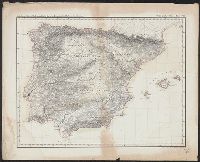
[Atlas nouveau contenant toutes les parties du monde ou sont exactement marques les empires
Image Count:
1
Resource Type:
Maps, Atlases & Globes
Abstract:
Factitious collection of about 549 maps taken from the atlases of the 17th and the beginning of the 18th century, put together with the title "Atlas" and bound in 6 volumes. These volumes originally bore the imprint: Amstelaedamii apvd Reiniervm & Josvam Ottens. Over these words on the title pages of volumes 1-2 and 4-6 is the name of Henrik de Leth who painted them.
Description:
Verso blank.
Subject (Geographic):
British Isles --Maps --Early works to 1800
Subject (Name):
Leth, Hendrik de, 1703-1766, Reiner et Josua Ottens (Firm), Schenck, Peter, 1661-1715, Schenck, Peter, ca. 1698-1752, Valck, G. (Gerard), 1651 or 2-1726, and Wit, Frederik de
Subject (Topic):
Atlases --Early works to 1800
Collection Created:
[A Amsterdam, chez J. Covens & C. Mortier, ca. 1730-ca. 1800]
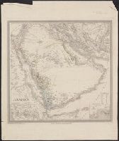
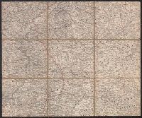
Abteilung II. Oro- und hydrographische Karte der Pyrenäischen Halbinsel, nach Berghaus, Oro- und hydrographische Karte der Pyrenäischen Halbinsel, nach Berghaus, and Platt's grosser Atlas der Erde.
Description:
Relief shown by hachures. and Stamp: Karpinski-von Wieser Map Collection.
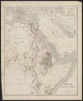
Appears in Allgemeiner Hand-Atlas der Erde und des Himmels nach den best, Prime meridian: Ferro., Relief shown by hachures and spot heights., and Shows physical and ethnographic features, regional and political boundaries, caravan trails, and tribal affiliation.
Subject (Geographic):
Aden (Yemen)--Maps, Arabian Peninsula--Maps, Mecca (Saudi Arabia)--Maps, and Sinai (Egypt)--Maps
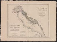
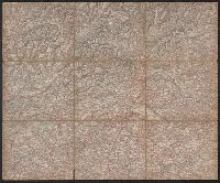
Herder, Bartholomä, 1774-1839, lithographer Woerl, Joseph Edmund Woerl, Joseph Edmund. Atlas von Central-Europa
Call Number:
30 1840B
Container / Volume:
BRBL_00031
Image Count:
1
Resource Type:
Maps, Atlases & Globes
Description:
From Woerl's Atlas von Central-Europa, 1830., Imperfect: trimmed along neat line, with loss of marginal data. Dissected and mounted on cloth., Relief shown by hachures., and Title from label on verso.
Subject (Geographic):
Baden-Württemberg (Germany)--Maps, Graubünden (Switzerland)--Maps, Tyrol (Austria)--Maps, and Vorarlberg (Austria)--Maps
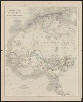
In lower right corner: 57., Relief shown by hachures., and Shows outlines of European possessions and select names and dates of European explorations from 1849 through 1862.
Subject (Geographic):
Africa, Eastern--Maps and Africa, North--Maps
Subject (Name):
Gräf, A. (Adolf), active 1855-1878 and Haubold, G. (Georg), engraver
In lower right corner: 56., Relief shown by hachures., and Shows outlines of European possessions and select names and dates of European explorations from 1850 through 1860.
From Woerl's Atlas von Central-Europa, 1830., Imperfect: trimmed along neat line, with loss of marginal data. Dissected and mounted on cloth., Relief shown by hachures., and Title from label on verso.
Subject (Geographic):
Dunántúl (Hungary)--Maps, Slovenia--Maps, and Styria (Austria)--Maps
Subject (Name):
Herder, Bartholomä, 1774-1839, lithographer and Woerl, Joseph Edmund. Atlas von Central-Europa