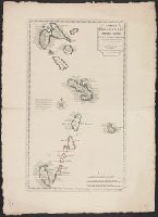
Includes text to left of compass rose: En 1706, le R.P. Feuillée observa dns l'Isle de la Martinique..., Includes three bar scales: lieues communes de France, lieues marines de France et d'Angleterre, and lieues marines d'Espagne., Relief shown pictorially., and Shows islands from Guadeloupe to Grenada, including Barbados.
Publisher:
Chez I'auteur sur le Quay de l'Horloge,
Subject (Geographic):
Antilles, Lesser--Maps--Early works to 1800, West Indies, French--Maps--Early works to 1800, and Windward Islands (West Indies)--Maps--Early works to 1800
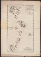
Hand col. Sheet measures 75.5 x 54 cm. Ms. no. on verso [some, Includes text to left of compass rose: En 1706, le R.P. Feuillée observa dns l'Isle de la Martinique..., Relief shown pictorially., and Shows islands from Guadeloupe to Grenada, including Barbados.
Publisher:
Chez I'auteur sur le Quay de l'Horloge,
Subject (Geographic):
Antilles, Lesser--Maps--Early works to 1800, West Indies, French--Maps--Early works to 1800, and Windward Islands (West Indies)--Maps--Early works to 1800
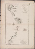
"Cette carte a été rectifiée en 1769 par Phil. Buache.", Cross Collection no. 257., Hand col., Includes three bar scales: lieues communes de France, lieues marines de France e, Ms. no. on verso: 134., and Relief shown pictorially.
Publisher:
Chez Dezauche, successeur des Srs. Del'Isle et Bauche ...,
Subject (Geographic):
Antilles, Lesser--Maps--Early works to 1800, West Indies, French--Maps--Early works to 1800, and Windward Islands (West Indies)--Maps--Early works to 1800
Subject (Name):
Buache, Philippe, 1700-1773, Dezauche, J, and Petit, Jean de
Buache, Philippe, 1700-1773 Dezauche, J L'Isle, Guillaume de, 1675-1726. Atlas géographique et universel
Published / Created:
[1781]
Call Number:
23 1750
Container / Volume:
BRBL_00018
Image Count:
1
Resource Type:
Maps, Atlases & Globes
Description:
"Advertiss, "Publiée sous le privilège de l'Académie des sciences.", Appears in L'Isle and Buache's Atlas géographique et universel. Paris : Dezauche, 1781-[1784]., Hand col. Mounted on linen. Sheet measures 51 x 71 cm., and Relief shown pictorially.
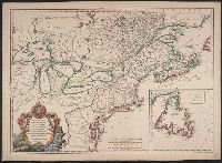
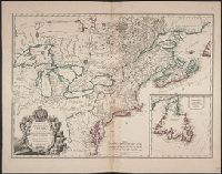
"Avec Privilege ... ", 1st state. Distinguishing feature of 1st state: "Area south of Lake Erie shows Ohio River running east to west, no forts" (Pedley 212)., Also shows Indian lands., Inset map: "Supplément pour l'isle de Terre-Neuve.", and Published separatel
Publisher:
Chés l'auteur, quai de l'horloge du palais proche le pont-neuf ... ,
Subject (Geographic):
Canada--Maps--Early works to 1800, Newfoundland and Labrador--Maps--Early works to 1800, and United States--History--French and Indian War, 1755-1763--Maps--Early works to 1800
Subject (Name):
Argenson, Marc-Pierre de Voyer, comte d', 1696-1764, dedicatee
Subject (Topic):
British--America--Maps--Early works to 1800, Cartographers--France--Paris, French--America--Maps--Early works to 1800, and Indians of North America--Maps--Early works to 1800
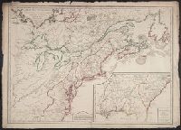
1st state. Distinguishing feature of 1st state: "Area south of Lake Erie shows Ohio River running east to west, no forts" (Pedley 212)., Includes "Supplément pour l'isle de Terre-Neuve.", and Shows British colonies as far south as the present state of North Ca
Publisher:
chés l'Auteur,
Subject (Geographic):
Canada--Maps--Early works to 1800, New France--Maps--Early works to 1800, Newfoundland and Labrador--Maps--Early works to 1800, and United States--Maps--Early works to 1800
Subject (Name):
Argenson, Marc-Pierre de Voyer, comte d', 1696-1764. dedication
Subject (Topic):
British--America--Maps--Early works to 1800 and French--America--Maps--Early works to 1800
Bonnet, Louis Marin, 1736-1793, engraver L'Isle, Guillaume de, 1675-1726
Published / Created:
1723
Call Number:
352 1723
Container / Volume:
BRBL_00104
Image Count:
1
Resource Type:
Maps, Atlases & Globes
Description:
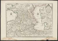
53 1723: Sheet measures 58.6 x 80.9 cm., Bar scales given in "wurst ou mils de Russie," "farsangues ou lieues de Perse," and "lieues communes de France"., Prime meridian: Ferro., Relief shown pictorially., Sheet measures 54.2 x 75.4 cm., and Watermark.
Publisher:
Chez le Sr. Delisle ...,
Subject (Geographic):
Caspian Sea Region--Maps--Early works to 1800 and Caucasus--Maps--Early works to 1800
Bar scales given in "wurst ou mils de Russie," "farsangues ou lieues de Perse," and "lieues communes de France"., Prime meridian: Ferro., Relief shown pictorially., Sheet measures 54.2 x 75.4 cm., Sheet measures 58.6 x 80.9 cm., and Watermark.
Publisher:
Chez le Sr. Delisle ...,
Subject (Geographic):
Caspian Sea Region--Maps--Early works to 1800 and Caucasus--Maps--Early works to 1800