Bar scales given in mill. Germanica sive geometrica 15 in uno gradu and milliaria Gallica magna sive horae itineris., No. 14 of 69 maps bound together in composite atlas., Relief shown pictorially., and Scale [ca. 1:680 000].
Dorn, Sebastian Hase, Johann Matthias, 1684-1742 Homann Erben (Firm)
Published / Created:
1744
Call Number:
1973 Folio 30
Collection Title:
[Atlas factice of 32 maps and 1 distance table, produced by the Homann Erben firm]
Image Count:
2
Alternative Title:
Carte d’Hongrie en general, contenant selon la division ancienne & methodique, la Hongrie, en particulier, la Croatie, la Dalmatie, la Bosnie, la Servie, la Boulgarie, la Principaute de Transylvanie, les Despotats de Walachie & de Moldav and Hungariae ampliori significatu et veteris vel methodicae, complexae regna: Hungariae Propriae, Crotiae, Dalmatiae, Bosniae, Serviae, Cumaniae, principatum: Transylvaniae, despotus: Walachiae, Moldaviae (exclusis ab eadem alienatis Galitia et Ludmomiria) in suas provincias ac partes divisae et quoad Imperantes ex Austriacis, Turcis et Venetis distinctae (juncta tamen propter commidatem Romania vel Romelia Turcica) tabula
Publisher:
Curantibus Homannianis Heredibus
Subject (Geographic):
Balkan Peninsula --Maps --Early works to 1800 and Hungary --Maps --Early works to 1800
Homann Erben (Firm) Homann, Johann Baptist, 1663-1724
Published / Created:
[1746?]
Call Number:
1973 Folio 30
Collection Title:
[Atlas factice of 32 maps and 1 distance table, produced by the Homann Erben firm]
Image Count:
2
Alternative Title:
Allemagne distinguee en ses cercles & subdivisee en ses etats, contenant son etendue presente rectifiee & methodiquement enluminee suivant les elements de geographie de Mr. Schatz and Imperii Romano Germanici in suos status et circulos divisi tabula generalis
Publisher:
[Homann Erben?]
Subject (Geographic):
Austria --Maps --Early works to 1800, Czechoslovakia --Maps --Early works to 1800, Germany --Maps --Early works to 1800, Hungary --Maps --Early works to 1800, and Poland --Maps --Early works to 1800
Homann Erben (Firm) Homann, Johann Baptist, 1663-1724
Published / Created:
ca. 1741
Call Number:
1975 Folio 31
Collection Title:
[Atlas factice of 42 maps, produced by the Homann Erben firm]
Image Count:
2
Alternative Title:
Allemagne distinguee en ses cercles & subdivisee en ses etats, contenant son etendue presente rectifiee & methodiquement enluminee suivant les elements de geographie de Mr. Schatz a 1741 avec privilege imperial and Imperii Romano Germanici in suos status et circulos divisi tabula generalis
Publisher:
Homann Erben?
Subject (Geographic):
Austria --Maps --Early works to 1800, Czechoslovakia --Maps --Early works to 1800, Germany --Maps --Early works to 1800, Hungary --Maps --Early works to 1800, and Poland --Maps --Early works to 1800
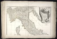
Anville, Jean Baptiste Bourguignon d', 1697-1782 Aveline, J. A. Coypel, Charles-Antoine, 1694-1752
Published / Created:
1743
Call Number:
1982 Folio 10
Image Count:
2
Description:
Also appeared in Anville's [Atlas general. Paris : Jean Baptiste Bourguignon d'Anville, 1771]., Covers also Corsica and Malta., Includes ornamental cartouche drawn and engraved by Coypet and Aveline., No. 17 of 43 maps bound together in composite atlas., Par le Sr. d'Anville ; de la gravure de P. Bourgoin., Relief shown pictorially., and Scale [ca. 1:1,500,000].
Bar scales given in mille pas geometriques, ou milles d'Italie, lieues communes de France, lieues d'une heure de Chemin, lieues communes d'Allemagne, and lieues communes de Suisse., Includes 33 coats of arms., No. 15 of 69 maps bound together in composite atlas., Relief shown pictorially., and Scale [ca. 1:585 000].
Publisher:
Chez H. Iaillot
Subject (Geographic):
Switzerland --Administrative and political divisions --Maps --Early works to 1800 and Switzerland --Maps --Early works to 1800
Cercle de Franconie, ou sont les eveches De Wurtzburg, de Bamberg, et d'Aichstet, les estats du grand Maistre des Chevaliers Teutons, les Marquisats de Cullembach, et d'Ohnspach, les Comtes d'Henneberg, d'Holach, de Reineck, de Wertheim, d'erpach, de Schwartzenberg, et de Castel, les Baronies de Limpurg, et de Sensheim, et les villes imperiales de Nurenberg, de Rotenburg, de Schweinfurt, Windsheim, et de Weissenburg
Description:
Bar scales in Italian miles, common leagues of Germany, great leagues of Germany, common leagues of France, great leagues of France, and leagues of one hours traveling., Dresse sur les Memoires les plus Nouveaux par le Sr. Sanson., Ferro meridian., No. 30 of 69 maps bound together in composite atlas., Relief shown pictorially., and Scale [ca. 1:510 000].