Skip to search
Skip to main content
Skip to first result
Search
You Searched For
Repository
Beinecke Rare Book and Manuscript Library
Format
cartographic
Language
Italian
New Search
Search Results
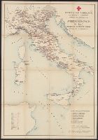
Published / Created:
1918
Call Number:
11hc 1919XX
Image Count:
1
Resource Type:
Maps, Atlases & Globes
Description:
Italian and English. and Shows Red Cross facilities, hospitals and war zones.
Publisher:
A. Marzi,
Subject (Geographic):
Italy--Maps
Found in:
Beinecke Rare Book and Manuscript Library > American Red Cross in Italy ; November 1917 to February 1919., Croce Rossa Americana : Dipartimento Sanitario, Novembre 1917 a Febbraio 1919 =
Creator:
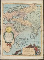
Published / Created:
1690?]
Call Number:
50 1700
Container / Volume:
BRBL_00271
Image Count:
1
Resource Type:
Maps, Atlases & Globes
Alternative Title:
Atlante veneto
Description:
Appears in the author's Atlante veneto, vol. 1., Borders filled with graduations of latitude and longitude., Includes decorative cartouche which includes a dedication to Tirso Gonzalez, Preposito Generale dell, and Yale copy lacking the eastern sheet; dgvmp2008.
Publisher:
s.n. ,
Subject (Geographic):
Asia--Maps--Early works to 1800
Found in:
Beinecke Rare Book and Manuscript Library > Asia divisa nelle sue parti secondo lo stato presente, descritta, e dedicata ... / dal P.M. Coronelli.
Creator:
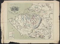
Published / Created:
[1855?]
Call Number:
35311hc Se21 1855C
Container / Volume:
BRBL_00112
Image Count:
1
Resource Type:
Maps, Atlases & Globes
Description:
Shows troop positions.
Publisher:
Anto. Vallardi,
Subject (Geographic):
Sevastopolʹ (Ukraine)--History--Siege, 1854-1855--Maps
Subject (Topic):
Crimean War, 1853-1856--Campaigns--Ukraine--Maps
Found in:
Beinecke Rare Book and Manuscript Library > Assedio di Sevastopoli / lit. di A. Vallardi ; Naymiller fece.
Published / Created:
1897
Call Number:
40 1897
Container / Volume:
BRBL_00202
Image Count:
1
Resource Type:
Maps, Atlases & Globes
Description:
"Edita dall 1st Geog. Milit. 1897".
Publisher:
Società del Bene Pubblico,
Subject (Geographic):
Liguria (Italy)--Maps
Found in:
Beinecke Rare Book and Manuscript Library > Bordighera e suoi dintorni.
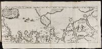
Published / Created:
[Ca. 1612]
Call Number:
Taylor 258
Collection Title:
Descriptio ac delineatio geographica detectionis freti, sive, transitus ad occasum supra terras
Image Count:
1
Alternative Title:
Caerte van’t noorderste Russen, Samojeden, ende Tingoesen landt
Description:
Bound in after p. [30]., Description of Siberia by Isaac Abrahamszoon Massa., Map cut and folded irregularly., Map has multiple small ink stains on verso at the top., Printed on recto in lower right corner: D3., and Scale not given.
Subject (Geographic):
Barents Sea --Maps --Early works to 1800
Subject (Name):
Massa, Isaac, 1587-1635
Collection Created:
Amsterodami Ex officina Hesse lij Gerardi. Anno 1613
Found in:
Beinecke Rare Book and Manuscript Library > Caerte van’t noorderste Russen, Samojeden, ende Tingoesen landt : alsoo dat vand Russen afghetekent, en door Isaac Massa vertaelt is
Published / Created:
[1780?]
Call Number:
40 P28 1780D
Container / Volume:
BRBL_00705
Image Count:
1
Resource Type:
Maps, Atlases & Globes
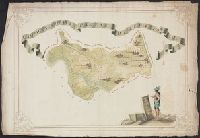
Description:
Color: various shades of green with some yellow detail. and Notes: Drawing of male figure in bottom right hand corner.
Subject (Geographic):
Italy--Maps, Manuscript--Early works to 1800
Found in:
Beinecke Rare Book and Manuscript Library > Campagna Soprana Pavese Delegazione V.
Published / Created:
[1780?]
Call Number:
40 P28 1780A
Container / Volume:
BRBL_00705
Image Count:
1
Resource Type:
Maps, Atlases & Globes
Description:
Color: various shades of green with some yellow detail. and Notes: Drawing of female figure on bottom right hand corner.
Subject (Geographic):
Italy--Maps, Manuscript--Early works to 1800
Found in:
Beinecke Rare Book and Manuscript Library > Campagna Sottana Pavese Delegazione VI.
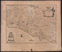
Published / Created:
[between 1640 and 1643]
Call Number:
406 1640
Container / Volume:
BRBL_00236
Image Count:
2
Resource Type:
Maps, Atlases & Globes
Description:
Relief shown pictorially., Signature 3M, page number 64 on verso., Stamp: Karpinski-von Wieser Map Collection., and Text on verso in Latin.
Publisher:
[Blaeu],
Subject (Geographic):
Campagna di Roma (Italy)--Maps--Early works to 1800 and Lazio (Italy)--Maps--Early works to 1800
Found in:
Beinecke Rare Book and Manuscript Library > Campagna di Roma, olim Latium : Patrimonio di S. Pietro et Sabina.
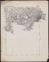
Published / Created:
1870?]
Call Number:
4073cbf 1870
Container / Volume:
BRBL_00237
Image Count:
3
Resource Type:
Maps, Atlases & Globes
Description:
Foglio 61 (Parte Orientale). Napoli -- Folgio 62 (Parte Occidentale). Castellammare -- Folgio 62 (Parte Orientale). Castellammare.
Publisher:
s.n.,
Subject (Geographic):
Campania (Italy)--Maps
Found in:
Beinecke Rare Book and Manuscript Library > Campania, section of Pozzuoli, Napoli, to Castellammare.
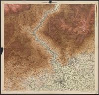
Published / Created:
[1918].
Call Number:
11hcf 1919D-7
Image Count:
1
Resource Type:
Maps, Atlases & Globes
Description:
"Con le aggiunte al 1̊ Maggio 1918."
Publisher:
Istituto Geografico militare,
Subject (Geographic):
Italy--Maps
Found in:
Beinecke Rare Book and Manuscript Library > Canale del Brenta.
Branch:v1.62.0 ,Deployed:2024-06-26T09:57:07-04:00