Skip to search
Skip to main content
Skip to first result
Search
You Searched For
Extent of Digitization
Partially digitized
Format
cartographic
Publication Place
London
New Search
Search Results
Creator:
Published / Created:
1756
Call Number:
Efd 726S
Collection Title:
A new voyage to Guinea: describing the customs, manners, soil, climate, habits, buildings
Image Count:
1
Resource Type:
Maps, Atlases & Globes
Publisher:
J. Nourse
Collection Created:
London, J. Nourse, 1744
Found in:
Beinecke Rare Book and Manuscript Library > A General Map of Senegal, Corrected and Improved with several particulars by Mr. Adanson, correspondent of the Royal Academy of Sciences. Drawn and executed by Philip Buache, 1756
Published / Created:
1704
Call Number:
Cxb e678ge
Collection Title:
The history of the bucaniers of America : from the first original down to this time; written in
Image Count:
1
Resource Type:
Maps, Atlases & Globes
Alternative Title:
[Piratas de América. English]
Publisher:
Printed for T. Newborough [etc.]
Collection Created:
London : Printed for T. Newborough [etc.],
Found in:
Beinecke Rare Book and Manuscript Library > A Map of the Countrey and Citty of Panama. Part 3: Chap: 5.
Creator:
Published / Created:
1752
Call Number:
1978 Folio 142
Collection Title:
A complete atlas, or distinct view of the known world; exhibited in sixty-eight maps ... in which
Image Count:
1
Publisher:
Printed for William Innys and Joseph Richardson [etc.]
Collection Created:
London, Printed for William Innys and Joseph Richardson [etc.] 1752
Found in:
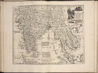
Beinecke Rare Book and Manuscript Library > A new and accurate mapof the Empire of the Great Mogul, together with India on both sides the Ganges, and the adjacent countries. Drawn fromt he most approved modern maps and charts: The whole being regulated by Astron's observations by Eman. Bowen
Creator:
Published / Created:
1673
Call Number:
1998 Folio 71
Image Count:
1
Resource Type:
Books, Journals & Pamphlets
Alternative Title:
[Gezantschap der Neerlandtsche Oost-Indische Compagnie aan den grooten Tartarischen Cham, den tegenwoordigen keizer van China. English]
Description:
Imperfect: wanting p. 411-412. Armorial bookplate (motto: Ferro comite): Sr. John Mordaunt.
Publisher:
Printed by the Author at his house in White-Friers
Subject (Geographic):
China --Description and travel. and Netherlands --Commerce --China
Found in:
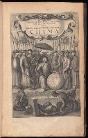
Beinecke Rare Book and Manuscript Library > An embassy from the East-India Company of the United Provinces, to the Grand Tartar Cham, Emperor of China : deliverd by their excellencies, Peter de Goyer and Jacob de Keyzer, at his imperial city of Peking : wherein the cities, towns, villages, ports, r
Creator:
Published / Created:
1775 Feb 20
Call Number:
1973 Folio 80
Collection Title:
The West-India atlas: or, A compendious description of the West-Indies: illustrated with forty
Image Count:
1
Resource Type:
Prints & Photographs
Description:
Includes scale.
Publisher:
Robt Sayer
Subject (Geographic):
Caribbean Sea --Maps. and West Indies --Maps
Subject (Topic):
Nautical charts --Caribbean Sea --To 1800
Collection Created:
London, Printed for R. Sayer and J. Bennett, 1780
Found in:
Beinecke Rare Book and Manuscript Library > Curacao from the Dutch originals of Gerard Van Keulen
Creator:
Published / Created:
1832
Call Number:
1978 Folio 106
Collection Title:
Maps of the Orinoco-Essequibo region, South America. Compiled for the Commission appointed by the
Image Count:
1
Resource Type:
Maps, Atlases & Globes
Subject (Geographic):
Caribbean Area--Maps--Early works to 1800, Colombia --Maps, Guyana --Maps, Orinoco River Valley (Venezuela and Colombia) --Maps, and Venezuela --Maps
Collection Created:
Washington, 1897
Found in:
Beinecke Rare Book and Manuscript Library > Part of a map of Colombia by J. Arrowsmith, London, 1832
Creator:
Published / Created:
[1766]
Call Number:
ByzL 79t
Collection Title:
A new and accurate history and survey of London, Westminster, Southwark, and places adjacent
Image Count:
1
Resource Type:
Maps, Atlases & Globes
Description:
Bound in between pp. 288-289 and Imperfect: 10 cm. tear at left.
Subject (Geographic):
London (England)--Aerial views--Early works to 1800, London (England)--Buildings, structures, etc.--Pictorial works--Early works to 1800, and London (England)--Maps--Early works to 1800
Collection Created:
London, E. and C. Dilly, MDCCLXVI
Found in:
Beinecke Rare Book and Manuscript Library > The London guide, or, a pocket plan of the cities of London & Westminster and Borough of Southwark; with the new buildings, &c. to the present year
Creator:
Published / Created:
1775 Feb 20
Call Number:
1973 Folio 80
Collection Title:
The West-India atlas: or, A compendious description of the West-Indies: illustrated with forty
Image Count:
1
Resource Type:
Prints & Photographs
Description:
Includes scale.
Publisher:
Robt Sayer
Subject (Geographic):
Caribbean Sea --Maps. and West Indies --Maps
Subject (Topic):
Nautical charts --Caribbean Sea --To 1800
Collection Created:
London, Printed for R. Sayer and J. Bennett, 1780
Found in:
Beinecke Rare Book and Manuscript Library > The Virgin Islands from English and Danish surveys
Published / Created:
1763 April
Call Number:
Z17 299b
Collection Title:
Universal museum; or, Gentleman's and ladies polite magazine of history politicks and literature.
Image Count:
1
Resource Type:
Books, Journals & Pamphlets
Subject (Geographic):
North America -- Maps -- Early works to 1800 and United States--History--French and Indian War, 1755-1763--Maps--Early works to 1800
Subject (Topic):
Periodicals--England
Collection Created:
London
Found in:
Beinecke Rare Book and Manuscript Library > Theodolite's Pattern, shewing the advantages obtained by the peace to England, particularly in North America.
Branch:v1.61.8 ,Deployed:2024-06-20T11:15:15-04:00