Part of the circle of Austria viz. the Archdukedom of Austria divided into the higher above the river Ens, and the lower below the Ens ... described by Sanson, corrected and amended by William Berry
Description:
Bar scales in Italian miles, common leagues of Germany, great leagues of Germany, leagues of Hungary, common leagues of France, and leagues of one hours travelling., Dedicated To the most serene and most sacred majesty James II ... by William Berry., Ferro meridian., No. 27 of 69 maps bound together in composite atlas., Relief shown pictorially., and Scale [ca. 1:510 000].
Publisher:
Sold by William Berry at the sign of the Globe between Charing-Cross, and White-Hall
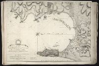
Also appeared in Faden's [General atlas. London : William Faden, 1811?]., In cartouche above title: The Roman obsidional crown, Parcere subjectis et debellare superbos., No. 15 of 43 maps bound together in composite atlas., Oriented with north toward right., Relief shown by hachures; depths by soundings., Scale [ca. 1:24,700]., and Shows ocean currents, buildings, forts, fields, magnetic declination, etc.
Publisher:
William Faden
Subject (Geographic):
Gibraltar --History --Siege, 1779-1783 --Maps --Early works to 1800, Gibraltar --Maps --Early works to 1800, and Gibraltar, Bay of (Spain) --Maps --Early works to 1800
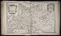
Territories of the crown of Poland subdivided into their severall palatinates ... described by Sanson, corrected and amended by William Berry
Description:
Bar scales in Italian miles, common leagues of France, common leagues of Germany, leagues of Hungary, common leagues of Poland, and great leagues of Poland., Dedicated To the most serene and most sacred majesty of Charles II ... by William Berry., Ferro meridian., No. 39 of 69 maps bound together in composite atlas., Relief shown pictorially., and Scale [ca. 1:2 100 000].
Publisher:
Sold by William Berry at the sign of the Globe between Charing-Cross and White-Hall
Catalonia under which name are comprehended the principality of Catalonia and the counties of Rossillion and of Cerdagne ... described by Sanson, corrected & amended by William Berry
Description:
Bar scales given in Italian miles, common leagues of France, common leagues of Spain, common leagues of Germany, and leagues of on houes travelling., Dedicated To the most serene and most sacred majesty of Charles II ... by William Berry., Includes coat of arms and decorative cartouche containing dedication., No. 11 of 69 maps bound together in composite atlas., Prime meridian: Ferro., Relief shown pictorially., and Scale [ca. 1:640 000].
Publisher:
Sold by William Berry at the signe of the Globe between Chering Cross and White Hall
Dominion of the Czar of Russia Alba or Great Duke of Moscovia ... described by Sanson, corrected and amended by William Berry, Moscovia, and Russia Alba
Description:
Bar scales in Italian miles, common leagues of France, common leagues of Germany, common leagues of Sweden or Great leagues of Germany, common leagues of Poland, verstes or common leagues of Moscovia, and leagues that are one hours travelling., Dedicated To the most serene and most sacred majesty Charles II ... by William Berry., Ferro meridian., No. 40 of 69 maps bound together in composite atlas., Relief shown pictorially., and Scale [ca. 1:6 000 000].
Publisher:
Sold by William Berry at the sign of the Globe between Charing-Cross and White-Hall
Scandinavia and its confines in which are the Kingdom's of Sweden, Denmark, and Norway divided into their principall provinces viz under the crown of Sweden ... described by Sanson, corrected and amended by Wilm. Berry
Description:
Bar scales in Italian miles, common leagues of France, common leagues of Germany & Denmark, Swedish or great German leagues, common leagues of Norway, verstes or leagues of Moscovy, and leagues of one hours traveling., Dedicated To the most serene and most sacred majesty Charles II ... by William Berry., Ferro meridian., No. 41 of 69 maps bound together in composite atlas., Relief shown pictorially., and Scale [ca. 1:4 000 000].
Publisher:
Sold by William Berry at ye sign of ye Globe between Charing-Cross and White-Hall
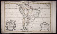
South America divided into its pricipall parts, viz. the Firm-land, Peru, Chili ... described by Sanson, corrected and amended by William Berry
Description:
Bar scales given in Italian miles, common leagues of France, common leagues of Spain, common leagues of Germany, and common English miles., Dedicated to Charles II by William Berry., No. 69 of 69 maps bound together in composite atlas., Prime meridian: Ferro., Relief shown pictorially., and Scale [ca. 1:16 000 000].
Publisher:
Sold by William Berry at the sign of the Globe between Charing-Cross and White-Hall
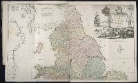
Kitchin, Thomas, d. 1784, creator Sayer, Robert, 1725-1794, publisher
Published / Created:
1787 January 1
Call Number:
1982 Folio 10
Image Count:
2
Alternative Title:
England & Wales and South Britain
Description:
Imperfect: both sheets torn along some folds, with some loss of text., Inset map: Isles of Scilly., London meridian., No. 5 of 43 maps bound together in composite atlas., Relief shown pictorially and by hill shading., and Scale [ca. 1:575,000].
Publisher:
R. Sayer
Subject (Geographic):
England --Maps --Early works to 1800 and Wales --Maps --Early works to 1800
Spain distinguisht into all its kingdoms, principalities & c., that is to say under the dominion of the Catholick king viz. the kingdom of Castile, Leon, Galicia ... described by Sanson, corrected and amended by William Berry
Description:
Bar scales given in Italian miles, common leagues of France, common leagues of Spain, common leagues of Germany, and English miles., Dedicated To the most serene and most sacred majesty of Charles II ... by William Berry, and dated 1682., Includes coat of arms and decorative cartouche containing dedication., No. 10 of 69 maps bound together in composite atlas., Prime meridian: Ferro., Relief shown pictorially., Scale [ca. 1:2 100 000]., and With inset map of Cadiz Bay.
Publisher:
Sold by William Berry at the signe of the Globe between Chering Cross and White Hall
Subject (Geographic):
Iberian Peninsula --Maps --Early works to 1800 and Spain --Maps --Early works to 1800
Delarochette, L. (Louis), 1731-1802, creator Faden, William, 1749-1836
Published / Created:
1782 March 20
Call Number:
1982 Folio 10
Image Count:
1
Description:
No. 37 of 43 maps bound together in composite atlas., Place names in Dutch; pictorial relief. "The red line describes the route of the British Army from its landing at Simons Baay to Cape Town.", and Scale [ca. 1:528 000].
Publisher:
W. Faden
Subject (Geographic):
Cape of Good Hope (South Africa) --Maps --Early works to 1800