Search
You Searched For
Search Results
- Creator:
- Chandos, James Brydges, Duke of, 1674-1744
Mayo, William., creator
Senex, John, d. 1740
- Published / Created:
- 1722
- Call Number:
- 2003 Folio 85
- Image Count:
- 1
- Found in:
- Beinecke Rare Book and Manuscript Library > A new & exact map of the island of Barbadoes in America: according to an actual & accurate survey made in the years 1717 to 1721, approved by the Royal Society & authorized by His Majesty's royal licence
- Creator:
- Bowen, Emanuel, d. 1767
- Published / Created:
- 1752
- Call Number:
- 1978 Folio 142
- Collection Title:
- A complete atlas, or distinct view of the known world; exhibited in sixty-eight maps ... in which
- Image Count:
- 1
- Found in:
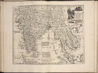
- Beinecke Rare Book and Manuscript Library > A new and accurate mapof the Empire of the Great Mogul, together with India on both sides the Ganges, and the adjacent countries. Drawn fromt he most approved modern maps and charts: The whole being regulated by Astron's observations by Eman. Bowen
- Creator:
- Browne, Christopher, fl. 1684-1712, creator
- Published / Created:
- [169-?]
- Call Number:
- 1973 Folio 10
- Image Count:
- 1
- Resource Type:
- Maps, Atlases & Globes
- Found in:
- Beinecke Rare Book and Manuscript Library > A new chart of the sea coasts of France: together with the English Chanell describing ye severall harbors, sands, rocks, and anchoridges, etc. on the said coasts
- Creator:
- Faden, William, 1749-1836, creator
- Published / Created:
- 1787 January 1
- Call Number:
- 1982 Folio 10
- Image Count:
- 1
- Found in:
- Beinecke Rare Book and Manuscript Library > A new general chart of the world : exhibiting the whole of the discoveries made by the late Captain James Cook, F.R.S. with the tracks of the ships under his command : also those of Cap'n Phipps (now Lord Mulgrave) in his expedition to the North Pole
- Creator:
- Beaufort, Daniel Augustus, 1739-1821, creator
Faden, William, 1749-1836
- Published / Created:
- 1792
- Call Number:
- 1982 Folio 10
- Image Count:
- 2
- Found in:
- Beinecke Rare Book and Manuscript Library > A new map of Ireland, civil and ecclesiastical
- Creator:
- Bowles, Carington, 1724-1793, creator
Sheffield, 18th cent
- Published / Created:
- [ca. 1762]
- Call Number:
- 2003 Folio 85
- Image Count:
- 1
- Found in:
- Beinecke Rare Book and Manuscript Library > A new map of Jamaica: in which the several towns, forts, & settlements are accurately laid down, as well as the situations & depths of the most noted harbours and anchoring places
- Creator:
- Jefferys, Thomas, d. 1771, creator
- Published / Created:
- 1755
- Call Number:
- 2003 Folio 85
- Image Count:
- 1
- Found in:
- Beinecke Rare Book and Manuscript Library > A new map of Nova Scotia, and Cape Britain: With the adjacent parts of New England and Canada, composed from a great number of actual surveys; and other materials regulated by many new astronomical observations of the longitude as well as latitude; with a
- Creator:
- Faden, William, 1749-1836, creator
- Published / Created:
- 1788 June 24
- Call Number:
- 1982 Folio 10
- Image Count:
- 2
- Found in:
- Beinecke Rare Book and Manuscript Library > A new map of the German empire and the neighbouring states with their principal post roads : originally published by the Royal Academy of Berlin
- Creator:
- Faden, William, 1749-1836
Jefferys, Thomas, d. 1771, creator
- Published / Created:
- 1789 June 1
- Call Number:
- 1982 Folio 10
- Image Count:
- 1
- Found in:
- Beinecke Rare Book and Manuscript Library > A new map of the King of Great Britain's dominions in Germany or the electorate of Brunswick-Luneburg and its dependencies
- Creator:
- Kitchin, Thomas, d. 1784, creator
Sayer, Robert, 1725-1794
- Published / Created:
- 1787 January 1
- Call Number:
- 1982 Folio 10
- Image Count:
- 1
- Found in:
- Beinecke Rare Book and Manuscript Library > A new map of the Kingdom of Poland with its dismembered provinces