An historical, geographical, commercial, and philosophical view of the American United States, and
Image Count:
1
Description:
Engraved by Russell, Constitution R., Grays Inn La. and Facing p. 2.
Publisher:
Publish'd as the Act directs, by H.D. Symonds, No. 20 Pater Noster Row
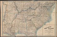
Subject (Geographic):
America --Description and travel, America --History --To 1810, New England --Maps --Early works to 1800, United States --Description and travel, and United States --Maps --Early works to 1800
Collection Created:
London, Printed for the editor; J. Ridgway [etc.] 1795
A list of other maps and atlases by Wyld is pasted on the verso., Description derived from published bibliography., and General map showing "dividing line between the free & slave-holding states."
Mediterranean Sea divided into the eastern and western seas, subdivides into its principal parts or seas ... described by Sanson, corrected and amended by William Berry
Description:
Based on La Mer Mediterranee divisee enses Principales Parties, ou Mers by Nicolas Sanson., Dedicated To the most serene and most sacred majesty James II ... by William Berry., Ms. mathematical annotations in left margin., No. 23 of 69 maps bound together in composite atlas., Relief shown pictorially., and Scale [ca. 1:610 000].
Publisher:
Sold by William Berry at the signe of the Globe between Charing-Cross and White-Hall
Eastern old world hemisphere has imprint: London ... Dec. 1st, 1786 by William Faden., No. 2 of 43 maps bound together in composite atlas., Scale [1:60,000,000]., and Shows western and eastern hemispheres separately.
Ed. statement appears on Northern Hemisphere map only., No. 3 of 43 maps bound together in composite atlas., Relief shown pictorially., Scale [ca. 1:41,000,000. At equator]., and Shows tracks of various ocean voyages.
Publisher:
William Faden
Subject (Geographic):
Northern Hemisphere --Maps --Early works to 1800 and Southern Hemisphere --Maps --Early works to 1800