At bottom: "Zu Num. 53 in dem II. Theil und zu Num. 73 in dem III. Theil.", In left margin: "Tabula geographica R.P. Eusebÿ Franc Kino Tridentini è Soc. IESU. Tabula chartae Patris Chino addita.", Inset: "Via terristris in Californiam comperta et detecta per R. Patrem Eusebium Fran. Chino è S.I. Germanum. Adnotatis novis missionibus esusdem Soctis ab Anno 1698 ad annum 1701.", Originally published in German Jesuit magazine Der Neue Welt-Bott., Relief shown pictorially., and Watermark
Publisher:
[P. Martin, und J. Veith],
Subject (Geographic):
Baja California (Mexico : Peninsula)--Maps. and Mexico--Baja California (Peninsula)
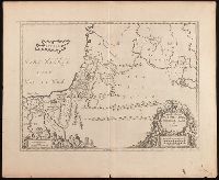
Tabvla itineraria patriarcharvm Abrahami, Isaaci et Jacobi
Description:
Includes three bar scales., Relief shown pictorially., Shows the itineraries of the patriarchs, Abraham, Isaac, and Jacob, especially in Canaan and the Nile Delta., and Watermark. Manuscript number in upper left corner: 39.
Publisher:
Apud Ioannem Ianssonium,
Subject (Geographic):
Middle East--Maps--Early works to 1800., Palestine--History--To 70 A.D.--Maps--Early works to 1800., and Palestine--Maps--Early works to 1800.
Subject (Topic):
Bible.--Old Testament--Geography--Maps--Early works to 1800.
"Cum priv. ord. gen. Holl. et Westfr.", Appeared in Peter Schenk's Atlas contractus [ca. 1700]., Backed with paper. Ms. no. "37" in lower-right corner. Sheet measures 63.1 x 53.7 cm. No. 36 of 87 maps bound together., Bar scales given in "milliaria Germanica" and "milliaria Gallica"., Prime meridian: Ferro., Relief shown pictorially., and Watermark.
Publisher:
Peter Schenk,
Subject (Geographic):
Lower Saxony (Germany)--Maps--Early works to 1800. and North Rhine-Westphalia (Germany)--Maps--Early works to 1800.
Subject (Name):
Schenk, Peter, 1660-1718 or 1719. Atlas contractus.
Claudii Ptolemaei Geographicae enarrationis libri octo.
Image Count:
2
Resource Type:
Maps, Atlases & Globes
Alternative Title:
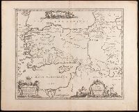
Tabula superioris Indiae & Tartariae maioris, Tabula superioris Indiae et Tartariae maioris, and Tabvla svperioris Indiae et Tartariae maioris.
Description:
Appears in the author's Geographia (Lyon, 1535 edition)., Caption title from verso., Descriptive text within ornamental borders on verso; paginated 43., In margin: climatic and latitudinal notes., Includes names of places and natural features., Map of the Far East and eastern Siberia., Relief shown pictorially., Text in Latin., and Watermark.
Publisher:
[Melchior and Gaspard Trechsel],
Subject (Geographic):
East Asia--Maps--Early works to 1800. and Siberia, Eastern (Russia)--Maps--Early works to 1800.
Subject (Name):
Ptolemy, 2nd cent., Trechsel, Gaspard, active 1529-1549, and Trechsel, Melchior, active 1529-1549
Bar scale given in "milliaria Germanica communia"., From Joan Blaeu's Théâtre du monde (1643-1650)., In French on verso with caption title "Tatarie," paginated "8," and with signature H., and Relief shown pictorially.
Publisher:
[Willem Janszoon Blaeu],
Subject (Geographic):
Asia, Central--Maps--Early works to 1800. and Siberia, Eastern (Russia)--Maps--Early works to 1800.
Subject (Name):
Blaeu, Joan, 1596-1673. Theatrum orbis terrarum. French.
Carte generale de la Tartarie chinoise et des royaumes de Corée et de Iapan
Description:
French alternate title only., Imperfect: western sheet (with cartouche) wanting. Sheet measures 54 x 54 cm, with watermark., Includes text and ill., and Relief shown pictorially.
Publisher:
Curis Homannianorum Heredum,
Subject (Geographic):
Chine--Divisions politiques et administratives--Cartes--Ouvrages avant 1800. and Manchuria (China)--Maps--Early works to 1800.
Subject (Name):
Anville, Jean Baptiste Bourguignon d', 1697-1782., Du Halde, J.-B. (Jean-Baptiste), 1674-1743., Gerbillon, Jean-François, 1654-1707., Homann Erben (Firm), and Mayer, Tobias, 1723-1762.
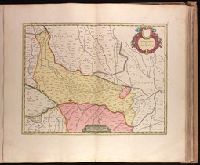
Backed with paper. Ms. no. "68" in upper right corner. Sheet measures 53.7 x 62.3 cm. No. 63 of 87 maps bound together., Bar scale given as "sette miglia Italiane.", Relief shown pictorially., and Watermark.
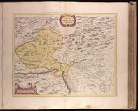
Backed with paper. Ms. no. in upper right corner: 17. Sheet measures 53.7 x 62.7 cm. No. 17 of 87 maps bound together., Includes one bar scale., Relief shown pictorially., Watermark., and With north oriented towards the bottom.
Publisher:
Joan Blaeu,
Subject (Geographic):
Basel-Stadt (Switzerland)--Maps--Early works to 1800. and Haut-Rhin (France)--Maps--Early works to 1800.