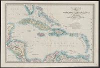
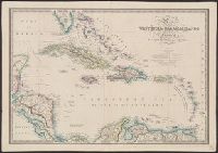
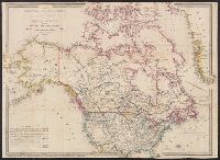
Cut and mounted on linen; "Wyld's new maps" advertisement on verso., Forts; boundaries; Indians; proposed railway; gold; coal., and Insets: Strait of San Juan de Fuca. -- on an enlarged scale. -- 7.4 x 8 cm.; British possessions in North America. -- scale [1:34
Publisher:
James Wyld,
Subject (Geographic):
British Columbia--Maps and Canada--Boundaries--United States--Maps
Subject (Topic):
Coal mines and mining--North America, Western--Maps, Gold mines and mining--British Columbia--Maps, and Indians--North America, Western--Maps
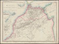
"31" in bottom right margin., Distances given in British miles, Spanish leagues, French kilometres, and Arabian miles., and Includes insets of Tangier Bay, Ceuta, Magador, City of Marocco.
"27" in top right-hand corner., Map showing N.S.W. and Victoria divided into counties with notes on the topography. Gold deposits are marked. Relief shown by hachures and spot heights., and Stamp on verso: Karpinski-von Wieser Map Collection.
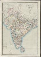
Includes India and parts of Bangladesh, Pakistan, Afghanistan, China, and Sri Lanka., Scale given in geographical miles, Carnatic Coss, Hindoostanee Coss, Hindoostanee Coss of Jehan, Hindoostanee Coss of Akbar, Malabar Gros or Gau, and Mysore Leagues., and Show
Publisher:
James Wyld,
Subject (Geographic):
India--Administrative and political divisions--Maps, India--Maps, and South Asia--Maps
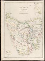
Inset: Kings Island., Map of Tasmania showing counties, railways and tramways with notes on the topography. Relief shown pictorially and by hachures and spot heights., Plate "28.", and Stamp on verso: Karpinski-von Wieser Map Collection.
Publisher:
James Wyld, Geographer to the Queen, 457, West Strand, Charing Cross East,