Skip to search
Skip to main content
Skip to first result
Search
You Searched For
Extent of Digitization
Completely digitized
Publication Place
London :
New Search
Search Results
Published / Created:
1801
Call Number:
27 1801
Container / Volume:
BRBL_00023A
Image Count:
1
Resource Type:
Maps, Atlases & Globes
Description:
Preliminary record.
Subject (Geographic):
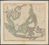
Indonesia--Maps
Found in:
Beinecke Rare Book and Manuscript Library > A New Map of the East India Isles. From the Latest Authorities. By John Cary, Engraver.
Published / Created:
1794
Call Number:
534 1794
Container / Volume:
BRBL_00289
Image Count:
1
Resource Type:
Maps, Atlases & Globes
Description:
Copy 2 is colored and in good condition.
Publisher:
Laurie & Whittle,
Subject (Geographic):
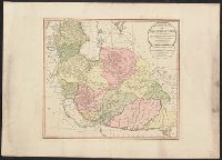
Iran--Maps--Early works to 1800
Found in:
Beinecke Rare Book and Manuscript Library > A New Map of the Empire of Persia from Monsr. DAnville ... with several Additions and Emendations.
Published / Created:
1794
Call Number:
534 1794
Container / Volume:
BRBL_00289
Image Count:
1
Resource Type:
Maps, Atlases & Globes
Publisher:
Laurie & Whittle,
Subject (Geographic):
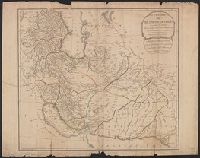
Iran--Maps--Early works to 1800
Found in:
Beinecke Rare Book and Manuscript Library > A New Map of the Empire of Persia from Monsr. DAnville ... with several Additions and Emendations.
Published / Created:
[ca. 1789]
Call Number:
6555cea 1789
Container / Volume:
BRBL_00708
Image Count:
3
Resource Type:
Maps, Atlases & Globes
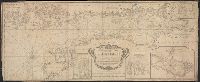
Description:
A plan of the Cove at Bassa with the adjacent roads., Entrace of the River Serra Leone vulgo Sierra Leon, 1775., Insets: Lagos and its Channels by Capt. Horsely of Liverpool 1789., and The Course of Gato or Regio Creek with the Entrance of River Benin by Capt. Archd. Dalzel, 1785.
Publisher:
Robert Sayer,
Subject (Geographic):
Ghana--Maps, Manuscript--Early works to 1800
Found in:
Beinecke Rare Book and Manuscript Library > A New Survey of that part of the Coast of Africa comprised between Cape Verga and Cape Formoso, including chiefly the Windward and Gold Coasts in which the Latitudes of all the Principal Places are determined by Actual observations, the bearings and cours
Published / Created:
1794
Call Number:
755cea 1794
Container / Volume:
BRBL_00441
Image Count:
4
Resource Type:
Maps, Atlases & Globes
Description:
From the North American pilot. A new ed. much enlarged of the second part of the North Am. Pilot. fol. London, R. Laurie & J. Whittle, 1800. and Insets: 1. Plan of Hell Gate with view of Hell Gate by W.A. Williams 1777. 2. The Rivers Kennebeck and Sheepcut by
Publisher:
Laurie & Whittle,
Subject (Geographic):
Canada--Maps--Early works to 1800 and East (U.S.)--Maps--Early works to 1800
Found in:
Beinecke Rare Book and Manuscript Library > A New and Correct Chart of the Coast of New England and New York with the adjacent parts of Nova Scotia and New Brunswick from Cape Sable to the entrance of Hudsons or North River by Captain Holland.
Published / Created:
[1764?]
Call Number:
76cea 1764
Container / Volume:
BRBL_00446
Image Count:
1
Resource Type:
Maps, Atlases & Globes
Description:
From the English Pilot, the Fourth Book, London, W.&I. Mount, T. Page, 1764 and later editions. and Inset of coast views.
Publisher:
W.&I. Mount & T. Page,
Subject (Geographic):
New England--Maps--Early works to 1800
Found in:
Beinecke Rare Book and Manuscript Library > A New and Correct Chart of the Sea Coast of New-England, from Cape Codd to Casco Bay. Lately Surbey'd by Capt. Henry Barnsley.
Published / Created:
1794
Call Number:
303cea 1794
Container / Volume:
BRBL_00033
Image Count:
1
Resource Type:
Maps, Atlases & Globes
Description:
Aspo Is. & Harbor: 1:15,000., Insets: Entrance & Harbor of Revel, 1:204,000., Kasperwik Bay: 1:35,000., and Plan of Cronstal: 1:125,000.
Publisher:
Laurie & Whittle,
Subject (Geographic):
Baltic Sea--Maps--Early works to 1800
Found in:
Beinecke Rare Book and Manuscript Library > A New and Correct chart of the Gulf of Finland ... Published by command of the Empress of all the Russias.
Published / Created:
1743
Call Number:
319 1743
Container / Volume:
BRBL_00040
Image Count:
1
Resource Type:
Maps, Atlases & Globes
Description:
Preliminary record. and Views and text.
Publisher:
Henry Overton,
Subject (Geographic):
British Isles--Maps--Early works to 1800
Found in:
Beinecke Rare Book and Manuscript Library > A New and exact map of Great Britain ... [Including Ireland].
Published / Created:
in the year. 1681.
Call Number:
BrSides By6 1681
Image Count:
1
Alternative Title:
Burton Hall. and Burton-Hall.
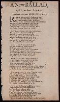
Description:
Begins: "Rowze up great monarch of this potent land".
Publisher:
Printed for Richard Sanders,
Subject (Topic):
Ballads, English and Brit Tracts--1681
Found in:
Beinecke Rare Book and Manuscript Library > A New ballad of London's loyalty : to a pleasant new tune, called Burton-Hall ...
Published / Created:
1681
Call Number:
BrSides By6 1681
Image Count:
2
Resource Type:
Books, Journals & Pamphlets
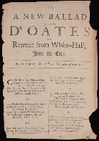
Alternative Title:
I'le tell thee Dick where I have been.
Description:
Begins: Can'st tell me, Ceres, what curst fate., Caption title., and Printed in double column.
Publisher:
Printed for W. Brown,
Subject (Name):
Oates, Titus,--1649-1705--Poetry
Subject (Topic):
Ballads, English and Brit Tracts--1681
Found in:
Beinecke Rare Book and Manuscript Library > A New ballad upon Dr. Oates his retreat from White-Hall into the city : to the tune of I'le tell thee Dick where I have been.
Branch:v1.61.8 ,Deployed:2024-06-20T11:14:48-04:00