From: Vancouver's A voyage of discovery to the North Pacific Ocean and round the world. London, 1798., Includes inset of "A survey of Port Chatham.", and Relief shown pictorially and by hachures. Depths shown by soundings.
Publisher:
J. Edwards & G. Robinson,
Subject (Geographic):
Alaska--Maps--Early works to 1800
Subject (Name):
Arnold, Robert M.--Ownership, Baker, Joseph, 1768-1817, Edwards, James, 1757-1816, Neele, Samuel John, 1758-1824, Robinson, G. G. (George G.), and Vancouver, George, 1757-1798. Voyage of discovery to the
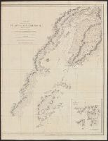
From: Vancouver's A voyage of discovery to the North Pacific Ocean and round the world. London, 1798., In top right margin: No. 12., Insets: Entrance into Cross Sound -- A survey of Port Conclusion -- A survey of Port Protection., and Relief shown pictorially and by hachures.
Publisher:
J. Edwards & G. Robinson,
Subject (Geographic):
Alaska--Maps--Early works to 1800
Subject (Name):
Arnold, Robert M.--Ownership, Baker, Joseph, 1768-1817, Edwards, James, 1757-1816, Foot, T. (Thomas), Robinson, G. G. (George G.), and Vancouver, George, 1757-1798. Voyage of discovery to the North Pacifi
"An appropriation of the 'Packman's Paternoster', by Sir James Sempill"--cf. Dict. nat. biog. and N. & Q. 2d ser., v. 11., Published earlier under title A pedlar and a Romish priest, in a very hot discourse ..., and Signatures: [A]-D4 (incl. front.).
Publisher:
Printed for, and sold by Henry Hills in Black-Fryers, near the Waterside,
Copper-engraved outline-chart. Coasts outlined in color by hand. Water-line at low tide outlined in blue on larger islands. Beaches, rocky headlands, sandhills, hidden tocks, anchorages, soundings. Jason's track around the island and into Port Stephens. and I
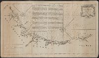
Coastal chart., Imperfect: Mutilated with loss of information., Includes text: "Instructions for the coast of South Carolina, Georgia, and the coast of St. Augustin"., and Oriented with north to the left.
Publisher:
W. Mount and T. Page,
Subject (Geographic):
Atlantic Coast (South Atlantic States)--Maps., Georgia--Maps--Early works to 1800., and South Carolina--Maps--Early works to 1800.
Subject (Topic):
Coastwise navigation--Atlantic Coast (South Atlantic States)