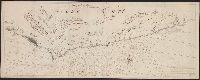
"Corrigée de nouveau sur la carte de Mr. Johannes Kyrilow ... ", Hand col. Lada-Mocarski Collection., Includes text of letter (in French and Dutch) written by "Monsieur Swartz ... a St. Petersbourg, and Title and place names in French. Text in French and Dutch.
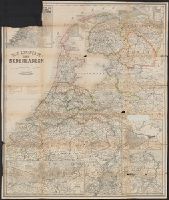
Inset: [1.] Hoogtekaart, tevens aanwijzende de veranderingen van land en water sedert het einde der 13de eeuw (17 x 19 cm); [2.] Omstreken van Arnhem (scale 1:100 000; 13 x 32 cm); [3.] De spoorweg- en havenwerken te Amsterdam (scale 1:40 000; 2 x 16,5 cm
Gouwen, Gilliam van der Visscher, Nicolaes, 1649-1702, creator
Published / Created:
[1690?]
Call Number:
1973 Folio 10
Image Count:
1
Resource Type:
Maps, Atlases & Globes
Alternative Title:
Landkaart vertonende het Graafschap Holland
Description:
Alternate title in upper margin: Landkaart vertonende het Graafschap Holland, seer dienstig om te reysen na : en van syne naburige provincien, als mede de Hoven van Soestdyk, 't Loo en Cleef / t' Amsteldam door Nicolaus Visscher met privilegie., Bar scales in Milliaria Germanica communia and Milliaria Gallica sive horae itineris., Ferro meridian., Includes col. ill. of figures in title cartouche., No. 44 of 69 maps bound together in composite atlas., Place-names in Dutch., Relief shown pictorially., and Scale [ca. 1:300 000].
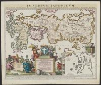
A variant of second state of the latinized atlas version of "Le Japon divisé en soissante et six provinces ...," with date "1715" below imprint. See: Lutz Walter, Japan: a cartographic vision, entry OAG 73 and Includes inset of Nagasaki and its surroundings.
Subject (Geographic):
Japan--Maps--Early works to 1800
Subject (Name):
Ottens, Joachim, 1663-1719, publisher and Ruyter, Balthasar, engraver