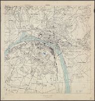
"3-43.", "Copied from a French map, 1:10,000, Plan de la ville de Rouen, 1933.", "First edition 1943.", Most streets and some buildings are named., Nord de guerre zone grid., and Street names and some points of interest in French.
France 1:7,350, Geographical Section, General Staff ; no. 4234, GSGS (Series) ; 4234., and Royan, plan of town
Description:
"First A.M.S. ed., 1943.", "First G.S.G.S. ed., 1943.", "Grid provisional. Lambert (zone II) grid.", "I-44.", "War Office 1943.", Important streets are named; key to points of interest in margin., and Major street names and some buildings in French.
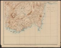
Carte de la partie occidentale de l 'Asie mineure and Map of the western part of Asia Minor
Description:
Covers western Anatolia and islands in Aegean Sea., Map in German; title in German, French, and English., Relief shown by shading and spot heights., and Sheet XV. only
Publisher:
Verlag von Dietrich Reimer,
Subject (Geographic):
Aegean Islands (Greece and Turkey)--Maps and Turkey--Maps
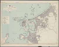
France 1:6,000, Geographical Section, General Staff ; no. 4234, GSGS (Series) ; 4234., Saint Malo, and St. Malo, plan of port and town
Description:
"G.S.G.S. edition, 1943.", "Grid provisional. Lambert zone I grid.", "I-44.", "War Office, 1943.", Principal street names, important buildings and port facilities are indicated., Relief shown by rock drawings., and Street names and some places of interest in French
"4-43.", "Copied from CB 1804, map 27.", "French Lambert zone II grid.", Major street names and place names in French., Relief shown by rock drawings., and Some streets and buildings are named.
Great Britain. War Office. General Staff. Geographical Section
Published / Created:
1919?]
Call Number:
434fd 1919
Container / Volume:
BRBL_00251
Image Count:
1
Resource Type:
Maps, Atlases & Globes
Alternative Title:
Czecho-Slovakia
Description:
"G.S.G.S. No. 2758.", "S.G.A. 2.4.19.", Also shows portions of Germany, Poland, Austria, Hungary, and Romania., In French and English., Relief shown by contours and spot heights., and Shows proposed boundaries and roads.
Publisher:
G.S.G.S.,
Subject (Geographic):
Czechoslovakia--Boundaries--Maps and Czechoslovakia--Maps
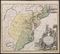
Also covers Delaware, southern Pennsylvania, New Jersey, western Long Island, southwestern Connecticut, and portions of adjacent areas., Bar scale given in "milliaria Germanica"., First appe, Includes ill., and Relief shown pictorially. Depths shown by soundings.