First impression of 3d French ed., Includes text and inset "Nouvelle carte de la baye d'Hudson et de Labrador selon les dernieres cartes levées sur les lieux.", Prime meridian: London., Relief shown pictorially., and Title in French and German.
Subject (Geographic):
North America--Maps--Early works to 1800
Subject (Name):
Hawkins, M., fl. 1776-1792 and Le Rouge, Georges-Louis
4th impression of 3d French ed. Cf. Ristow, W.W. A la carte, p. 112., Includes text and inset "Nouvelle carte de la baye d'Hudson et de Labrador selon les dernieres cartes levées sur les lieux.", Prime meridian: London., Relief shown pictorially., and Title in F
Publisher:
Le Rouge?,
Subject (Geographic):
North America--Maps--Early works to 1800
Subject (Name):
Hawkins, M., fl. 1776-1792 and Le Rouge, Georges-Louis
40 1838A: Stamp: Fürstlich Oettingen-Wallerstein'sche Bibliothek in Seyfriedsberg., In Italian and German. Legend in Italian, German and French., Includes tables, text, and Shows detailed postal route information between Marseille, Augsburg, Warsaw, and Naples.
Publisher:
Poste nelle Prove. Venete,
Subject (Geographic):
France, Germany, and Italy--Maps
Subject (Name):
Botte, Antonio Federico and Fürstlich Oettingen-Wallerstein'sche Bibliothek in Seyfriedsberg Stamp
Subject (Topic):
Post roads--France--Maps, Post roads--Germany--Maps, Post roads--Italy--Maps, Postal service--France--Maps, Postal service--Germany--Maps, and Postal service--Italy--Maps
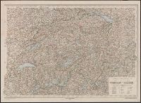
French and German., Relief shown by contours, gradient tints, and spot heights. Contours at 20 meter intervals., Sheets 2-6 wanting., and Shows hiking trails and paths.
Publisher:
Institut géographique Kümmerly & Frey,
Subject (Geographic):
Jura Mountains (France and Switzerland)--Maps
Subject (Name):
Kümmerly + Frey
Subject (Topic):
Hiking--Jura Mountains (France and Switzerland)--Maps and Trails--Jura Mountains (France and Switzerland)--Maps
Carte drôlatique d'Europe pour 1870 and Karte von Europa im Jahre 1914, gezeichnet von W. Trier
Description:
Poster showing Europe at different times with national political attitudes represented by caricatures. and Text and map place names in German and French.
Publisher:
Ernst Marx,
Subject (Name):
Trier, Walter, 1890-1951.
Subject (Topic):
World War, 1914-1918--Europe., World War, 1914-1918--Germany., and World War, 1914-1918--Posters.
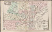
Describes location of steam railroad passenger depots., From Gray's atlas, p. 60-61., Legend in English, French and German., and Shows steam and horse railroads, wards, parks, etc.
Mappe-monde qui représente les deux hemisphères savoir celui de l'orient et celui de l'occident, tirée des quatre cartes générales de feu M. le profess. Hasius, Planiglobii terrestris mappa vniversalis, and Schul-Atlas von zwantzig General- und Special-Lan
Description:
Appears in Homann heirs' Schul-atlas von zwantzig general-und special-land karten ... Cf. Phillips, no. 293., Imperfect: torn along fold, with no loss of text. Shee, Map colored to show distribution of religions., and Title in Latin and French; legend in German.
Publisher:
Homann Erben],
Subject (Name):
Hase, Johann Matthias, 1684-1742 and Homann Erben (Firm)
Subject (Topic):
Religion--Maps--Early works to 1800 and World maps--Early works to 1800