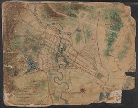
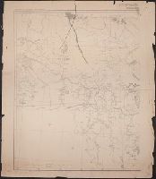
Map of Horse Railroad, Westville, and part of New Haven
Description:
Imperfect: mutilated., Map attributed to Donald Grant Mitchell., Backed with paper., Relief shown by hachures., "Scale of five inches to mile.", Color: green with blue and red detail., and Coordinates not present on map and are approximated.
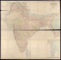
BEIN Covers 59 +1882: Dissected and mounted on linen., Relief shown by hachures., "Published by Wm. Allen & Co., April 3rd, 1870, corrections to 1882.", and Inset: Continuation of British Burmah.
Publisher:
W.H. Allen & Co.
Subject (Geographic):
South Asia, India, Nepal, Bhutan, Bangladesh, and Burma
Imperfect: mutilated. Mounted on linen. Manuscript note on verso (partially trimmed): Map of old P[?]; D.G. Mitchell., Date of production precedes statement of responsibility., Oriented with north towards right., Relief shown by hachures., "Scale: 140 ft. to inch.", Coordinates not present on map and are approximated., Includes names of ownership., and Includes inset map of surrounding area in lower right corner.
Goddard, George H. (George Henry), 1817-1906, cartographer
Published / Created:
[1855?]
Call Number:
BrSides Zc72 855gn
Image Count:
2
Resource Type:
cartographic image
Description:
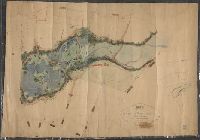
BEIN Broadsides Zc72 855gn: Mounted on linen. Autograph: H.W. Turner. Withdrawn stamp: Map Collection, University of California Library., Oriented with north toward upper right., Relief shown by hachures., Shows settlements, roads, ditches, flumes, etc., Includes table of distances., and Coordinates not present on map and are approximated.
Publisher:
Lith of Britton & Rey
Subject (Geographic):
California, Calaveras County, Calaveras County (Calif.), Mokelumne Hill Canal (Calif.), and Calaveras County.
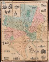
BEIN 766 N46 1859: Dissected and mounted on linen., BEIN Roll Map 485: Imperfect: mutilated, brittle, and chipped. Mounted on linen with wooden strip at top., Relief shown by hachures., "Scale 300 ft. to an inch.", Coordinates not present on map and are approximated., and Includes 15 vignettes and inset map "A plan of the town of New Haven with all the buildings in 1748."
Publisher:
Published by Eneas Smith and W.H. Rease's Lithographic Establishment, N.E. cor. 4th & Chestnut St.
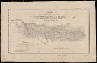
BEIN Covers 59 1855: Autograph on verso: Geo. Drummond, Madras., Covers southern half of India: N 25°--N 8° and E 73°--E 86°., "Compiled and drawn by J.S. Harvey, Qr. Mr. Genls. Office, Madras"--lower left corner., and Case title: Madras Presidency.
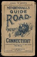
BEIN 766 1909: Original wrappers. Illegible inscription on front wrapper., Also has a 48 page Route Guide to Massachusetts, Connecticut & R.I. This company also published maps of the west in the 1870's, under the name Edward Mendenhall. Covers are brown card board 18.5x11.5 printed with an illustration of three people in an automobile and the title "Mendenhall's Guide And Road-Map of Connecticut With District Maps. C.S. Mendenhall, Map Publisher, Cincinnati. Price 75 Cts.", and Coordinates not present on map and are approximated.
United States. War Department. Corps of Engineers, cartographer, publisher
Published / Created:
[1881]
Call Number:
831 1881A
Image Count:
2
Resource Type:
cartographic image
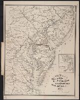
Description:
Relief shown by hachures., Scale "1 inch - 12 miles.", Shows battle sites and military expeditions, with dates., Westernmost sheet: "2nd edition May 1875 compiled under direction of Capt. Wm. Ludlow, Corps of Engrs."--Lower left margin., and In upper left margin: Brig. Genl. A.A. Humphreys, Chief of Engineers.
United States. War Department. Corps of Engineers, cartographer, publisher
Published / Created:
[1875?]
Call Number:
831 1875
Image Count:
1
Resource Type:
cartographic image
Description:
BEIN 831 1875: Imperfect: eastern sheet wanting; western sheet chipped. Inscription below edition statement: Lieut. [?] F. Eng., 5th Infty. Inscription on verso: Capt. Ludlow's map, 1875, sheet no. 1., Relief shown by hachures., Scale "1 inch - 12 miles.", Shows battle sites and military expeditions, with dates., and In upper left margin: Brig. Genl. A.A. Humphreys, Chief of Engineers.