
You Searched For
1 - 2 of 2
Search Results
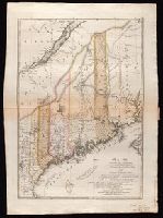
1. Maine / entworfen von D.F. Sotzmann ; Sander, sc.
- Creator:
- Bohn, Carl Ernst
Ebeling, Christophe Daniel, 1741-1817. Erdbeschreibung und Geschichte von Amerika
Sander, Wilhelm, 1766-1836, engraver
Sotzmann, D. F - Published / Created:
- 1798
- Call Number:
- 1977 Folio 177
- Image Count:
- 2
- Resource Type:
- Maps, Atlases & Globes
- Description:
- "Zu Ebelings Erdbeschreibung von America.", Also shows county boundaries., Bar scales given in "Geographische Meilen 15 auf einen Grad" and "Englische meilen 69 4/25 auf einen Grad.", In upper right margin: No. IV., Includes index to land grants., Place names in German and English., Prime meridians: Greenwich and Washington., Relief shown by hachures., Sheet measures 74.0 x 53.1 cm. Presentation inscription from C.D. Eberling to Noah Webster. No. 9 of 34 maps bound together., and Watermark.
- Publisher:
- Bey Carl Ernst Bohn,
- Subject (Geographic):
- Maine--Administrative and political divisions--Maps--Early works to 1800 and Maine--Maps--Early works to 1800
- Subject (Name):
- Ebeling, Christoph Daniel,--1741-1817--Presentation inscription to N. Webster and Webster, Noah,--1758-1843--Presentation inscription from C.D. Ebeling
- Found in:
- Beinecke Rare Book and Manuscript Library > Maine / entworfen von D.F. Sotzmann ; Sander, sc.
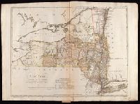
2. New York / entworfen von D.F. Sotzmann.
- Creator:
- Bohn, Carl Ernst
Ebeling, Christophe Daniel, 1741-1817. Erdbeschreibung und Geschichte von Amerika
Sander, Wilhelm, 1766-1836, engraver
Sotzmann, D. F - Published / Created:
- 1799
- Call Number:
- 1977 Folio 177
- Image Count:
- 2
- Resource Type:
- Maps, Atlases & Globes
- Description:
- "W. Sander, sculp.", "Zu Ebelings Erdbeschreibung von Amerika.", Bar scales given in "Geographische Meilen oder ein Grad des Aequators" and "Englische meilen 69 4/25 auf einen Grad.", In upper right margin: No. VII., Place names in English and German., Prime meridians: Greenwich and Washington., Relief shown by hachures., Sheet measures 53.9 x 74.0 cm. Presentation inscription from C.D. Eberling to Noah Webster. No. 5 of 34 maps bound together., Shows county and some township boundaries., and Watermark.
- Publisher:
- Bey Carl Ernst Bohn,
- Subject (Geographic):
- New York (State)--Administrative and political divisions--Maps--Early works to 1800 and New York (State)--Maps--Early works to 1800
- Subject (Name):
- Ebeling, Christoph Daniel,--1741-1817--Presentation inscription to N. Webster and Webster, Noah,--1758-1843--Presentation inscription from C.D. Ebeling
- Found in:
- Beinecke Rare Book and Manuscript Library > New York / entworfen von D.F. Sotzmann.