Skip to search
Skip to main content
Skip to first result
Search
You Searched For
Resource Type
Maps, Atlases & Globes
Creator
Great Britain. War Office. General Staff. Geographical Section
Publication Place
Washington,
New Search
Search Results
Creator:
Published / Created:
1943
Call Number:
685 Sf18 1943
Container / Volume:
BRBL_00351
Image Count:
1
Resource Type:
Maps, Atlases & Globes
Alternative Title:
GSGS (Series) ; 4275. and Provisional G.S.G.S. ; 4275
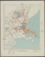
Description:
In upper margin: Tunisia 1:7,500 ... and Principal streets and buildings are named.
Publisher:
Army Map Service, U.S. Army,
Subject (Geographic):
Ṣafāqis (Tunisia)--Maps
Found in:
Beinecke Rare Book and Manuscript Library > Sfax; city plan. Drawn and reproduced by 512 Fd. survey coy. R. E.
Creator:
Published / Created:
1943
Call Number:
68 Si13 1943
Container / Volume:
BRBL_00350
Image Count:
1
Resource Type:
Maps, Atlases & Globes
Alternative Title:
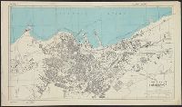
Geographical Section, General Staff ; no. 4275 and GSGS (Series) ; 4275.
Description:
"Prepared under the direction of the chief of engineers, U. S. Army, 1943. Compiled from aerial photographs, 1:12,000, G. S. G. S. no. 4275, Sidi Bel Abbès, 1942.", "Projection approximate.", and In upper margin: Algeria 1:10,000 ...
Publisher:
Army Map Service, U. S. Army,
Subject (Geographic):
Sidi Bel Abbès (Algeria)--Maps
Found in:
Beinecke Rare Book and Manuscript Library > Sidi Bel Abbès; city plan.
Creator:
Published / Created:
1942
Call Number:
212 1942
Container / Volume:
BRBL_00014
Image Count:
1
Resource Type:
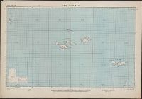
Maps, Atlases & Globes
Alternative Title:
Geographical section. General staff ; no. 4331 and GSGS (Series) ; 4331.
Description:
Military grid. and Spot heights in meters.
Publisher:
Army Map Service, U.S. Army,
Subject (Geographic):
Azores--Maps
Found in:
Beinecke Rare Book and Manuscript Library > The Azores. Compiled and drawn at the War Office, 1942.
Creator:
Published / Created:
1942
Call Number:
68 T54 1942
Container / Volume:
BRBL_00350
Image Count:
1
Resource Type:
Maps, Atlases & Globes
Alternative Title:
Geographical Section, General Staff ; 4275 and GSGS (Series) ; 4275.
Description:
In upper margin: Algeria ... and Military grid.
Publisher:
Army Map Service, U. S. Army,
Subject (Geographic):
Tlemcen (Algeria)--Maps
Found in:
Beinecke Rare Book and Manuscript Library > Tlemcen.
Creator:
Published / Created:
1943
Call Number:
68 B43 1943
Container / Volume:
BRBL_00350
Image Count:
1
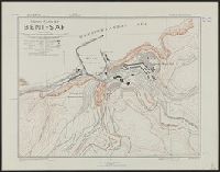
Resource Type:
Maps, Atlases & Globes
Alternative Title:
Geographical Section, General Staff ; no. 4275 and GSGS (Series) ; 4275.
Description:
"C. B. 4096 L ... Provisional ... Plan 45, Oct. 1942.", "Contours at 10 metres interval.", In upper margin: Algeria ..., and Military grid.
Publisher:
Army Map Service, U.S. Army,
Subject (Geographic):
Beni Saf (Algeria)--Maps
Found in:
Beinecke Rare Book and Manuscript Library > Town plan of Beni-Saf.
Creator:
Published / Created:
1942
Call Number:
68 B61 1942
Container / Volume:
BRBL_00350
Image Count:
1
Resource Type:
Maps, Atlases & Globes
Alternative Title:
Geographical Section, General Staff ; no. 4275 and GSGS (Series) ; 4275.
Description:
In upper margin: Algeria ... and Military grid.
Publisher:
Army Map Service, U.S. Army,
Subject (Geographic):
Blida (Algeria)--Maps
Found in:
Beinecke Rare Book and Manuscript Library > Town plan of Blida.
Creator:
Published / Created:
1942
Call Number:
68 B663 1942
Container / Volume:
BRBL_00350
Image Count:
1
Resource Type:
Maps, Atlases & Globes
Alternative Title:
Geograpical Section, General Staff ; no. 4275 and GSGS (Series) ; 4275.
Description:
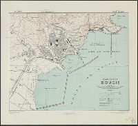
"Contour interval, 10 metres.", In upper margin: Algeria ..., and Military grid.
Publisher:
Army Map Service, U.S. Army,
Subject (Geographic):
Bejaïa (Algeria)--Maps
Found in:
Beinecke Rare Book and Manuscript Library > Town plan of Bougie.
Creator:
Published / Created:
1942
Call Number:
67 C26 1942
Container / Volume:
BRBL_00348
Image Count:
1
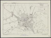
Resource Type:
Maps, Atlases & Globes
Alternative Title:
Geographical Section, General Staff ; no. 4241, GSGS (Series) ; 4241., and Morocco 10 000.
Description:
Based on French plan dated 1935., Important streets are named., In upper margin: Morocco ..., and Military grid.
Publisher:
Army Map Service, U. S. Army,
Subject (Geographic):
Casablanca (Morocco)--Maps
Found in:
Beinecke Rare Book and Manuscript Library > Town plan of Casablanca.
Creator:
Published / Created:
1943. and Army Map Service, U. S. Army,
Call Number:
675 C33 1943
Container / Volume:
BRBL_00349
Image Count:
1
Resource Type:
Maps, Atlases & Globes
Alternative Title:
Geographical Section, General Staff ; no. 4241 and GSGS (Series) ; 4241.
Description:
"Contours at 10 metres interval.", "Published by War office, 1942. Revised by A. M. S. December, 1942.", Important streets and buildings are named., In upper margin: Morocco ..., and Military grid.
Subject (Geographic):
Ceuta (Morocco)--Maps
Subject (Name):
United States. Army Map Service
Found in:
Beinecke Rare Book and Manuscript Library > Town plan of Ceuta.
Branch:v1.61.8 ,Deployed:2024-06-20T11:14:46-04:00