Skip to search
Skip to main content
Skip to first result
Search
You Searched For
Extent of Digitization
Partially digitized
Format
cartographic
Genre
Hand coloring
New Search
Search Results
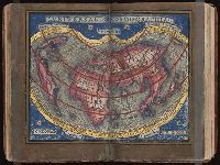
Published / Created:
[1542]
Call Number:
Taylor 86
Collection Title:
Rvdimenta cosmographica
Image Count:
1
Alternative Title:
Universalis cosmographia
Description:
Map of the world
Subject (Topic):
Cosmography, Early maps, and Geography, Medieval
Collection Created:
Impressvm in inclyta Transylvaniae Corona 1542
Found in:
Beinecke Rare Book and Manuscript Library > Vniversalis cosmographia
Creator:
Published / Created:
ca. 1730-ca. 1800]
Call Number:
1973 Folio 71
Image Count:
1
Resource Type:
Maps, Atlases & Globes
Description:
All volumes bound to match 1973 Folio 72. Factitious collection of about 549 maps taken from the atlases of the 17th and the beginning of the 18th cent., put together with the title "Atlas" and bound in 6 volumes. These volumes originally bore the imprint: Amstelaedamii apvd Reiniervm & Josvam Ottens. Over these words on the title-pages of v. 1-2, 4-6 is the name of Henrik de Leth who painted them. Volume 3 has only the erased imprint of Ottens., For fuller description see Phillips 3448 and C. Koeman's Atlantes Neerlandici, bibliography of terrestrial, maritime and celestial atlases and pilot books, published in the Netherlands up to 1800, Amsterdam c1967-71, v. 2, p. 63-83., and Maps by P. Schenck and son, G. Valck, F. de Wit, N. Visscher and others.
Publisher:
chez J. Covens & C. Mortier,
Subject (Geographic):
Denmark --Maps --Early works to 1800
Subject (Name):
Reiner et Josua Ottens (Firm), Schenk, Peter, 1660-1718 or 1719., and Valck, G. (Gerard), 1651 or 1652-1726.
Subject (Topic):
Atlases--Early works to 1800.
Found in:
Beinecke Rare Book and Manuscript Library > [Atlas nouveau contenant toutes les parties du monde ou sont exactement marqués les empires, monarchies, royaumes, états, republiques &c. Le tout recueilli par les meilleurs geógraphes.]
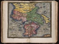
Published / Created:
[1542]
Call Number:
Taylor 86
Collection Title:
Rvdimenta cosmographica
Image Count:
1
Subject (Geographic):
Balkan Peninsula and Greece
Subject (Topic):
Cosmography, Early maps, and Geography, Medieval
Collection Created:
Impressvm in inclyta Transylvaniae Corona 1542
Found in:
Beinecke Rare Book and Manuscript Library > [Map of the Balkan Peninsula including Macedonia and Greece]
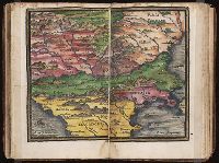
Published / Created:
[1542]
Call Number:
Taylor 86
Collection Title:
Rvdimenta cosmographica
Image Count:
1
Subject (Geographic):
Balkan Peninsula
Subject (Topic):
Cosmography, Early maps, and Geography, Medieval
Collection Created:
Impressvm in inclyta Transylvaniae Corona 1542
Found in:
Beinecke Rare Book and Manuscript Library > [Map of the Balkan Peninsula including Macedonia, Blugaria, Moldova]
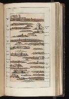
Published / Created:
1802
Call Number:
Im B388 Zz802B
Collection Title:
The imperial guide : with picturesque plans of the great post roads, containing miniatures
Image Count:
1
Description:
Bound in between p. 24-25. and William Beckford’s copy, with his penciled annotations. Autograph of William Beckford.
Subject (Geographic):
England --Guidebooks, England --Maps, Great Britain --Description and travel --Views, and Great Britain --Road maps
Subject (Topic):
Roads --Great Britain
Collection Created:
London : Printed by C. Whittingham, Dean Street, Fetter Lane, and sold by H.D. Symonds, Paternoster-Row; [etc], 1802
Found in:
Beinecke Rare Book and Manuscript Library > [Map: Carlisle to Bolton]
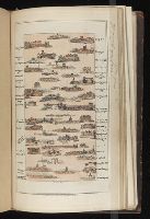
Published / Created:
1802
Call Number:
Im B388 Zz802B
Collection Title:
The imperial guide : with picturesque plans of the great post roads, containing miniatures
Image Count:
1
Description:
Bound in between p. 4-5. and William Beckford’s copy, with his penciled annotations. Autograph of William Beckford.
Subject (Geographic):
England --Guidebooks, England --Maps, Great Britain --Description and travel --Views, and Great Britain --Road maps
Subject (Topic):
Roads --Great Britain
Collection Created:
London : Printed by C. Whittingham, Dean Street, Fetter Lane, and sold by H.D. Symonds, Paternoster-Row; [etc], 1802
Found in:
Beinecke Rare Book and Manuscript Library > [Map: Coventry to Stony Stratford]
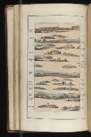
Published / Created:
1802
Call Number:
Im B388 Zz802B
Collection Title:
The imperial guide : with picturesque plans of the great post roads, containing miniatures
Image Count:
1
Description:
Bound in between p. 38-39. and William Beckford’s copy, with his penciled annotations. Autograph of William Beckford.
Subject (Geographic):
England --Guidebooks, England --Maps, Great Britain --Description and travel --Views, and Great Britain --Road maps
Subject (Topic):
Roads --Great Britain
Collection Created:
London : Printed by C. Whittingham, Dean Street, Fetter Lane, and sold by H.D. Symonds, Paternoster-Row; [etc], 1802
Found in:
Beinecke Rare Book and Manuscript Library > [Map: Islip to Paddington]
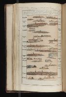
Published / Created:
1802
Call Number:
Im B388 Zz802B
Collection Title:
The imperial guide : with picturesque plans of the great post roads, containing miniatures
Image Count:
1
Description:
Bound in between p. 22-23. and William Beckford’s copy, with his penciled annotations. Autograph of William Beckford.
Subject (Geographic):
England --Guidebooks, England --Maps, Great Britain --Description and travel --Views, and Great Britain --Road maps
Subject (Topic):
Roads --Great Britain
Collection Created:
London : Printed by C. Whittingham, Dean Street, Fetter Lane, and sold by H.D. Symonds, Paternoster-Row; [etc], 1802
Found in:
Beinecke Rare Book and Manuscript Library > [Map: Lancaster to Worsley]
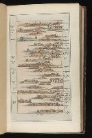
Published / Created:
1802
Call Number:
Im B388 Zz802B
Collection Title:
The imperial guide : with picturesque plans of the great post roads, containing miniatures
Image Count:
1
Description:
Bound in between p. 6-7. and William Beckford’s copy, with his penciled annotations. Autograph of William Beckford.
Subject (Geographic):
England --Guidebooks, England --Maps, Great Britain --Description and travel --Views, and Great Britain --Road maps
Subject (Topic):
Roads --Great Britain
Collection Created:
London : Printed by C. Whittingham, Dean Street, Fetter Lane, and sold by H.D. Symonds, Paternoster-Row; [etc], 1802
Found in:
Beinecke Rare Book and Manuscript Library > [Map: Stafford to Coventry]
Published / Created:
1802
Call Number:
Im B388 Zz802B
Collection Title:
The imperial guide : with picturesque plans of the great post roads, containing miniatures
Image Count:
1
Description:
Bound in between p. 10-11. and William Beckford’s copy, with his penciled annotations. Autograph of William Beckford.
Subject (Geographic):
England --Guidebooks, England --Maps, Great Britain --Description and travel --Views, and Great Britain --Road maps
Subject (Topic):
Roads --Great Britain
Collection Created:
London : Printed by C. Whittingham, Dean Street, Fetter Lane, and sold by H.D. Symonds, Paternoster-Row; [etc], 1802
Found in:
Beinecke Rare Book and Manuscript Library > [Map: Talk on the Hill to Birmingham]
Branch:v1.61.8 ,Deployed:2024-06-20T11:14:48-04:00