Search
You Searched For
Search Results
- Published / Created:
- 1833
- Call Number:
- 1976 Folio 98
- Collection Title:
- A new universal atlas, containing maps of the various empires, kingdoms, states and republics of
- Image Count:
- 1
- Resource Type:
- Maps, Atlases & Globes
- Found in:
- Beinecke Rare Book and Manuscript Library > A new map of Maine
- Published / Created:
- 1850
- Call Number:
- 1976 Folio 96
- Collection Title:
- A new universal atlas containing maps of the various empires, kingdoms, states and republics of the
- Image Count:
- 1
- Resource Type:
- Maps, Atlases & Globes
- Found in:
- Beinecke Rare Book and Manuscript Library > A new map of Maine
- Call Number:
- 1976 Folio 94
- Collection Title:
- A new universal atlas containing maps of the various empires, kingdoms, states and republics of the
- Image Count:
- 1
- Resource Type:
- Maps, Atlases & Globes
- Found in:
- Beinecke Rare Book and Manuscript Library > A new map of Maine
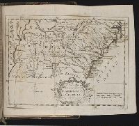
- Creator:
- Aitken, Robert, 1735-1802
- Published / Created:
- 1775 September
- Call Number:
- A89 P384
- Collection Title:
- The Pennsylvania magazine: or, American monthly museum
- Image Count:
- 1
- Resource Type:
- Books, Journals & Pamphlets
- Found in:
- Beinecke Rare Book and Manuscript Library > A new map of North & South Carolina, & Georgia
- Call Number:
- 1977 +379
- Collection Title:
- Geografia; cioe, Descrittione vniversale della terra. Partita in due volumi, nel primo de' quali si
- Image Count:
- 1
- Found in:
- Beinecke Rare Book and Manuscript Library > A new map of that part of Africacalled the coast of Guinea ...
- Creator:
- Moll, Herman, d. 1732
- Published / Created:
- [1732]
- Call Number:
- E1015 M66 1732
- Collection Title:
- Atlas minor: or a set of sixty-two new and correct maps, of all parts of the world. All composed
- Image Count:
- 1
- Found in:
- Beinecke Rare Book and Manuscript Library > A new map of the whole world with the trade winds according to ye latest and most exact observations by H. Moll geographer.
- Creator:
- Moll, Herman, d. 1732
- Published / Created:
- [1732]
- Call Number:
- E1015 M66 1732
- Collection Title:
- Atlas minor: or a set of sixty-two new and correct maps, of all parts of the world. All composed
- Image Count:
- 1
- Found in:
- Beinecke Rare Book and Manuscript Library > A new map of ye north parts of America claimed by France under ye names of Louisiana. Mississipi, Canada & New France, with the adjoyning territories of England & Spain. By H. Moll geographer.
- Creator:
- Visscher, Nicolaes, 1649-1702
- Published / Created:
- Undated
- Call Number:
- 1973 Folio 71
- Collection Title:
- [Atlas nouveau contenant toutes les parties du monde ou sont exactement marques les empires
- Image Count:
- 1
- Resource Type:
- Maps, Atlases & Globes
- Found in:
- Beinecke Rare Book and Manuscript Library > A new mapp of the kingdome of England, representing the princedome of Wales, and other provinces, cities, market towns, with the roads from town to town and the number of reputed miles between them, are given by inspection without scale or compass
- Call Number:
- 1977 Folio 78
- Collection Title:
- A New and accurate chart of the West-India Islands and coast, with the gulf passage through the New
- Image Count:
- 1
- Resource Type:
- Maps, Atlases & Globes
- Found in:
- Beinecke Rare Book and Manuscript Library > A plan of Fort St. Louis harbour on the south side of Hispaniola, pl. 31.
- Call Number:
- 1977 Folio 78
- Collection Title:
- A New and accurate chart of the West-India Islands and coast, with the gulf passage through the New
- Image Count:
- 1
- Resource Type:
- Maps, Atlases & Globes
- Found in:
- Beinecke Rare Book and Manuscript Library > A plan of Monte-Christe Bay with the Seven Brothers on the north coast of St. Domingo, pl. 38