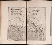
In upper right margin: Taf. VI., Possibly from Ukert's Geographie der Griechen und Römer von den frühesten zeiten bis auf Ptolemäus., and Relief shown by hachures.
Subject (Geographic):
Spain--Maps
Subject (Name):
Ukert, F. A. (Friedrich August), 1780-1851. Geographie der Griechen und Römer von den frühesten zeiten bis auf Ptolemäus
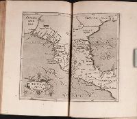
Americae pars quinta nobilis & admiratione plena Hieronymi Bezoni Mediolanensis secundae sectionis
Image Count:
1
Subject (Geographic):
America --Discovery and exploration --Spanish --Early works to 1800, America --Early accounts to 1600, Latin America --Description and travel --Early works to 1800, Latin America --History --To 1600, and Mexico --Ma
Subject (Name):
Benzoni, Girolamo, b. 1519. Historia del Mondo Nuovo. Book 2. Latin, Bry, Theodor de, 1528-1598, and Chauveton, Urbain, d. ca. 1616
Coordinates not present on map and are approximated., Includes index to points of interest in German, profile of fortress, and ill., Manuscript number in upper right corner: 75., Relief shown by hachures., and Watermark.
Subject (Geographic):
Ochakiv (Ukraine)--Maps--Early works to 1800
Subject (Topic):
Ochakov, Battle of, Ochakiv, Ukraine, 1737--Maps and Russo-Turkish War, 1736-1739--Maps
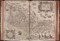
Mappa Aestivarvm insularum, alias Barmvdas dictarum
Description:
Below map, list of proprietors in 12 columns flanked by coats-of-arms., Borders are hand colored., and Not hand colored. With watermark. Sheet measures 46 x 55 cm.
Manuscript number in upper right corner: 116., Relief shown pictorially., and Watermark.
Subject (Geographic):
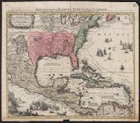
Caribbean Area--Maps--Early works to 1800, Central America--Maps--Early works to 1800, Mexico--Maps--Early works to 1800, North America--Maps--Early works to 1800, and United States--Maps--Early works to 1800