
You Searched For
« Previous
| 1 - 10 of 22 |
Next »
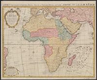
Search Results
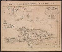
2.
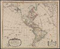
- Creator:
- L'Isle, Guillaume de, 1675-1726
- Published / Created:
- 1774
- Call Number:
- 70 1774A
- Container / Volume:
- BRBL_00724
- Image Count:
- 1
- Resource Type:
- Maps, Atlases & Globes
- Alternative Title:
- America accurate in imperia, regna, status, et populos divisa, ad usum Ludovici XV. Galliarum Regis
- Description:
- In French, with additional title in Latin., Includes "Avertissement"., Relief shown pictorially., and Sheet measures 51.5 x 63 cm. Numbered "108" in ink ms. Franklin Collection.
- Publisher:
- Chez Covéns & Mortier & Covéns Junior,
- Subject (Geographic):
- America--Maps--Early works to 1800
- Subject (Name):
- Anville, Jean Baptiste Bourguignon d', 1697-1782, Condet, Johannes, 1711-1781, engraver, and Covens et Mortier et Covens, junior
- Found in:
- Beinecke Rare Book and Manuscript Library > Carte d'Amerique : divisées en ses principales parties / par G. Delisle, premier geographe du Roy, rectifiée apres les nouvelles observations du Sr. D'Anville et autres geographes ; J. Condet, sc.
3.
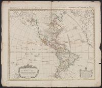
- Creator:
- L'Isle, Guillaume de, 1675-1726
- Published / Created:
- 1774
- Call Number:
- 70 1774A
- Container / Volume:
- BRBL_00356
- Image Count:
- 1
- Resource Type:
- Maps, Atlases & Globes
- Alternative Title:
- America accurate in imperia, regna, status, et populos divisa, ad usum Ludovici XV. Galliarum Regis
- Description:
- In French, with additional title in Latin., Includes "Avertissement"., Relief shown pictorially., and Sheet measures 58.5 x 69 cm. Stamp on verso: "Yale Horace Brown 1900S".
- Publisher:
- Chez Covéns & Mortier & Covéns Junior,
- Subject (Geographic):
- America--Maps--Early works to 1800
- Subject (Name):
- Anville, Jean Baptiste Bourguignon d', 1697-1782, Condet, Johannes, 1711-1781, engraver, and Covens et Mortier et Covens, junior
- Found in:
- Beinecke Rare Book and Manuscript Library > Carte d'Amerique : divisées en ses principales parties / par G. Delisle, premier geographe du Roy, rectifiée apres les nouvelles observations du Sr. D'Anville et autres geographes ; J. Condet, sc.
4.
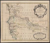
- Creator:
- L'Isle, Guillaume de, 1675-1726
- Published / Created:
- [1730?]
- Call Number:
- 655 1730
- Container / Volume:
- BRBL_00345
- Image Count:
- 1
- Resource Type:
- Maps, Atlases & Globes
- Description:
- Covers portion of western Africa from Mauritania to Guinea., Includes text and ornamental cartouche., Prime meridian: Ferro., Relief shown pictorially., and Verso: stamped "Map Collection Yale Univ. Library" and numbered "46" in ink in upper right corner.
- Publisher:
- Chez Jean Ćovens et Corneille Mortier,
- Subject (Geographic):
- Africa, West--Maps--Early works to 1800
- Subject (Name):
- Ćovens et Mortier
- Found in:
- Beinecke Rare Book and Manuscript Library > Carte de l'Afrique françoise ou du Senegal : dresśee sur un grand nombre de cartes manuscrites et d'itineraires rectifíes par diverses observations / par G. de l'Isle ...
5.
- Creator:
- L'Isle, Guillaume de, 1675-1726
- Published / Created:
- [1730]
- Call Number:
- 853 1722
- Container / Volume:
- BRBL_00694
- Image Count:
- 1
- Resource Type:
- Maps, Atlases & Globes
- Alternative Title:
- Insulae S. Dominicae tabula accuratissima.
- Description:
- "Lieues marines Fr, Also shows southern part of Bahamas and Turks and Caicos Islands., Appears in de L'Isle's Atlas nouveau., Cross Collection no. 268., Ms. no. on verso: 10A., and Relief shown pictorially. Depths shown by shading.
- Publisher:
- Chez Jean Cóvens et Corneille Mortier, geographes,
- Subject (Geographic):
- Bahamas--Maps--Early works to 1800, Hispaniola--Maps--Early works to 1800, and Turks and Caicos Islands--Maps--Early works to 1800
- Subject (Name):
- Cóvens et Mortier, Frézier, Amédée François, 1682-1773, and L'Isle, Guillaume de, 1675-1726. Atlas nouveau
- Found in:
- Beinecke Rare Book and Manuscript Library > Carte de l'Isle de Saint Domingue / dressée en 1722 pour l'usage du Roy sur les memoires de Mr. Frezier, ingenieur de S.M. et autres, assujettis aux observations astronomiques, par G. De l'Isle ...
6.
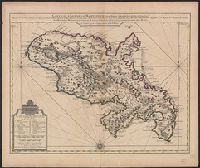
- Creator:
- L'Isle, Guillaume de, 1675-1726
- Published / Created:
- [1742]
- Call Number:
- 865 1732A
- Container / Volume:
- BRBL_00696
- Image Count:
- 1
- Resource Type:
- Maps, Atlases & Globes
- Description:
- Bar scales given in "Lieues Marines et d'Espagne de 17 1/2 au Degré" and "Lieues Com. de France dont 25 font un Degré.", From Guillaume de L'Isle's Atlas nouveau, contenant toutes les parties du monde. Amsterdam : Chez Jean Cóvens & Corneille Mortier, [1742]., and Prime meridian: Ferro.
- Publisher:
- Chez Jean Covens et Corneille Mortier, geographes,
- Subject (Geographic):
- Martinique--Maps--Early works to 1800
- Subject (Name):
- Buache, Philippe, 1700-1773, Cóvens et Mortier, printer, and L'Isle, Guillaume de, 1675-1726. Atlas nouveau
- Found in:
- Beinecke Rare Book and Manuscript Library > Carte de l'Isle de la Martinique : colonie françoise de l'une des Isles Antilles de l'Amérique / dressée sur des plans manuscrits entr'autres sur celui de Mr. Houel, Ingenieur du Roy, assujetis à des observations astonomiques et concilies avec des mem
7.
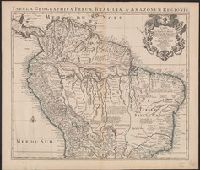
- Creator:
- L'Isle, Guillaume de, 1675-1726
- Published / Created:
- [1730?]
- Call Number:
- 90 1720
- Container / Volume:
- BRBL_00698
- Image Count:
- 1
- Resource Type:
- Maps, Atlases & Globes
- Alternative Title:
- Tabula geographica Peruae, Brasiliae & Amazonum Regiones
- Description:
- "Avec privil.", Appears in Cóvens and Mortier's Atlas nouveau; cf. Koeman, C. Atlantes Neerlandici, II C & M 4., Cross Collection no. 326., Mounted in linen., Ms. no. on verso: no. 108., Prime meridian: Ferro., and Relief shown pictorially.
- Publisher:
- Chez Iean Covens et Corneille Mortier ...,
- Subject (Geographic):
- South America--Maps--Early works to 1800
- Subject (Name):
- Cóvens et Mortier. Atlas nouveau
- Found in:
- Beinecke Rare Book and Manuscript Library > Carte de la Terre Ferme, du Perou, du Bresil et du Pays des Amazones [cartographic material] : dressée sur les descriptions de Herrera, de Laet, et des PP. Acuña, et M. Rodriguez et sur plusieurs relations et observations posterieures / par Guillaume De
8.
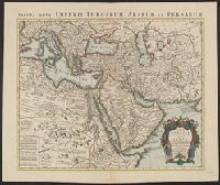
- Creator:
- L'Isle, Guillaume de, 1675-1726
- Published / Created:
- [after 1757]
- Call Number:
- 501 1720
- Container / Volume:
- BRBL_00275
- Image Count:
- 1
- Resource Type:
- Maps, Atlases & Globes
- Alternative Title:
- Tabula nova Imperii Turcarum Arabum et Persarum
- Description:
- Appeared in de L'Isle's Atlas nouveau (after 1757)., Includes five bar scales., Prime meridian: Ferro., Relief shown pictorially., and With watermark. Sheet measures 54.8 x 65.7 cm.
- Publisher:
- Chez Iean Cóvens et Corneille Mortier,
- Subject (Geographic):
- Africa, Northeast--Maps--Early works to 1800 and Middle East--Maps--Early works to 1800
- Subject (Name):
- L'Isle, Guillaume de, 1675-1726. Atlas nouveau
- Found in:
- Beinecke Rare Book and Manuscript Library > Carte de la Turquie de l'Arabie et de la Perse [cartographic material] : dressée sue les memoires les plus recens rectifiez par les observations de Mrs de l'Académie Royle. des Sciences / par G. de L'Isle, Geographe.
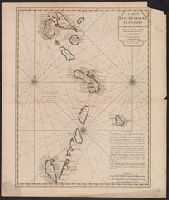
9.
- Creator:
- L'Isle, Guillaume de, 1675-1726
- Published / Created:
- [1730]
- Call Number:
- 858 1706
- Container / Volume:
- BRBL_00643
- Image Count:
- 1
- Resource Type:
- Maps, Atlases & Globes
- Description:
- Appears in Cóvens et Mortier's Atlas nouveau., Date from Tooley., Includes three bar scales: lieues communes de France, lieues marines de France et d'Angleterre, and lieues marines d'Espagne., Ms. no. on verso: 58., and Relief shown pictorially.
- Publisher:
- Chez Jean Cóvens et C. Mortier ...,
- Subject (Geographic):
- Antilles, Lesser--Maps--Early works to 1800, West Indies, French--Maps--Early works to 1800, and Windward Islands (West Indies)--Maps--Early works to 1800
- Subject (Name):
- Cóvens et Mortier. Atlas nouveau and Petit, Jean de
- Found in:
- Beinecke Rare Book and Manuscript Library > Carte des Antilles françoises et des isles voisines : dressée sur les memoires manuscrits de Mr. Petit, ingenieur de Roy, et sur quelques observations / par Guillaume de l'Isle de l'Academie rle. des sciences, et Premier Géographe du Roy.
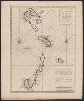
10.
- Creator:
- L'Isle, Guillaume de, 1675-1726
- Published / Created:
- [1730]
- Call Number:
- 85 1730
- Container / Volume:
- BRBL_00692
- Image Count:
- 1
- Resource Type:
- Maps, Atlases & Globes
- Description:
- Appears in Cóvens et Mortier's Atlas nouveau., Date from Tooley., Includes three bar scales: lieues communes de France, lieues marines de France et d'Angleterre, and lieues, and Sheet measures 64.1 x 54.3 cm. Ms. no. on verso: No. 105. Cross Collection no. 242.
- Publisher:
- Chez Jean Cóvens et C. Mortier ...,
- Subject (Geographic):
- Antilles, Lesser--Maps--Early works to 1800, West Indies, French--Maps--Early works to 1800, and Windward Islands (West Indies)--Maps--Early works to 1800
- Subject (Name):
- Cóvens et Mortier. Atlas nouveau and Petit, Jean de
- Found in:
- Beinecke Rare Book and Manuscript Library > Carte des Antilles françoises et des isles voisines : dressée sur les memoires manuscrits de Mr. Petit, ingenieur de Roy, et sur quelques observations / par Guillaume de l'Isle de l'Academie rle. des sciences, et Premier Géographe du Roy.