Skip to search
Skip to main content
Skip to first result
Search
You Searched For
Genre
Maps in books
Resource Type
Prints & Photographs
New Search
Search Results
Creator:
Published / Created:
1775 Feb 20
Call Number:
1973 Folio 80
Collection Title:
The West-India atlas: or, A compendious description of the West-Indies: illustrated with forty
Image Count:
1
Resource Type:
Prints & Photographs
Description:
Includes scale.
Publisher:
Robt Sayer
Subject (Geographic):
Caribbean Sea --Maps. and West Indies --Maps
Subject (Topic):
Nautical charts --Caribbean Sea --To 1800
Collection Created:
London, Printed for R. Sayer and J. Bennett, 1780
Found in:
Beinecke Rare Book and Manuscript Library > Curacao from the Dutch originals of Gerard Van Keulen
Creator:
Published / Created:
1829
Call Number:
Egf +827G
Image Count:
4
Resource Type:
Prints & Photographs
Publisher:
Cadell & co. [etc.],
Subject (Geographic):
Canada--Pictorial works, Georgia--Description and travel, United States--Aerial views, and United States--Pictorial works
Subject (Name):
Creek Indians
Subject (Topic):
Camera lucida and Indians of North America--Georgia
Found in:
Beinecke Rare Book and Manuscript Library > Forty etchings : from sketches made with the camera lucida, in North America, in 1827 and 1828 ... / By Captain Basil Hall.
Creator:
Published / Created:
1805
Call Number:
Folio Q115 H84 5
Collection Title:
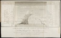
Essai sur la geographie des plantes, accompagne dun tableau physique des regions equinoxiales
Image Count:
1
Resource Type:
Prints & Photographs
Description:
At foot: Esquisse et redige par M. de Humboldt, dessine par Schonberger et turpin a Paris en 1805, grave par Bouquetm la Lettre par Beauble, imprime par Langlois.
Subject (Geographic):
South America
Subject (Topic):
Botany --South America., Discoveries in geography., and Plants
Collection Created:
Paris : F. Schoell, 1807
Found in:
Beinecke Rare Book and Manuscript Library > Geographie des plantes equinoxiales. / Tableau physiquw des Andes et Pays voisins/ Dresse d'apres des Observations & des Mesures preises Sir les Lieux depuis le 10 degre de latitude boreale jusqu'au 10 de latitude australe en 1799, 1800, 1801, 1802 at 180
Creator:
Published / Created:
1775 Feb 20
Call Number:
1973 Folio 80
Collection Title:
The West-India atlas: or, A compendious description of the West-Indies: illustrated with forty
Image Count:
1
Resource Type:
Prints & Photographs
Description:
Includes scale.
Publisher:
Robt Sayer
Subject (Geographic):
Caribbean Sea --Maps. and West Indies --Maps
Subject (Topic):
Nautical charts --Caribbean Sea --To 1800
Collection Created:
London, Printed for R. Sayer and J. Bennett, 1780
Found in:
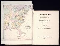
Beinecke Rare Book and Manuscript Library > The Virgin Islands from English and Danish surveys
Branch:v1.61.6 ,Deployed:2024-06-12T09:55:33-04:00