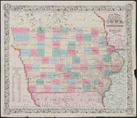
"Entered according to Act of Congress in the year 1851, by J.H. Colton in the Clerks Office of the Dist. Court for the Southn. Dist. of New York.", Includes census figures by county, Prime meridians: Greenwich and Washington., and Shows post roads and railroads.
Publisher:
J.H. Colton,
Subject (Geographic):
Iowa--Maps
Subject (Name):
Atwood, John M., b. ca. 1818 and Colton, G. Woolworth (George Woolworth), 1827-1901
Railroad and military map of the United States, Mexico, the West Indies &c.
Description:
In upper left margin: No. 7. and Insets: Map of the Americas, Africa and a portion of Europe, showing the Atlantic and part of the Pacific oceans -- New Orleans and delta of the Mississippi, Louisiana -- Mobile Harbor, Alabama -- Key West and Tortugas, Florid
Publisher:
J.H. Colton,
Subject (Geographic):
Central America--Maps, Mexico--Maps, United States--Maps, and West Indies--Maps
Subject (Topic):
Military bases--United States--Maps and Railroads--United States--Maps
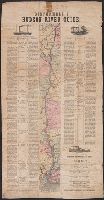
"Engraved by J.M. Atwood. N.Y.", "Showing the proposed routes to the Pacific Ocean.", Relief shown by hachures., and Shows canals, steamboat lines, finished and unfinished railroads.
Publisher:
J. Disturnell,
Subject (Geographic):
Canada--Maps and United States--Maps
Subject (Name):
Disturnell, John, 1801-1877
Subject (Topic):
Railroads--Canada--Maps and Railroads--United States--Maps
Carl I. Wheat map collection. CU-BANC and New map of the United States and Canada
Description:
Covers southern Canada, including New Brunswick, Prince Edward Island, and Nova Scotia., Inset: Map of Oregon, California, New Mexico & c. [continuation of main map, 1:10,600,000], and Main map extends west to cover most of Montana, Wyoming, Colorado, most of N
Publisher:
Published by J. Disturnell,
Subject (Geographic):
Canada--Maps and United States--Maps
Subject (Name):
Atwood, John M., b. ca. 1818 and Disturnell, John, 1801-1877
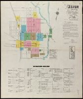
Fire insurance map, colored to show building construction, property boundaries and house and block numbers.
Alternative Title:
Dover, Del., Dover, Delaware, and June 1919, Dover, Del.
Description:
"15 sheets (2729).", Coordinates not present on map and are approximated., Includes index to streets and buildings., Sheet 1 includes key to building colors and other features of construction, water facilities and fire department, index map for the adjoining sheets., and Stamps on sheet 1: CLF 33650; Sep. 9, 1919.
Publisher:
Sanborn Map Company,
Subject (Geographic):
Dover (Del.)--Maps.
Subject (Topic):
Fire risk assessment--Delaware--Dover--Maps. and Real property--Delaware--Dover--Maps.