Search
You Searched For
Search Results
- Creator:
- United States. General Land Office
- Published / Created:
- 1903
- Call Number:
- 822 1903
- Container / Volume:
- BRBL_00567
- Image Count:
- 1
- Resource Type:
- Maps, Atlases & Globes
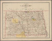
- Description:
- Relief shown by shading.
- Publisher:
- Dept. of the Interior, General Land Office,
- Subject (Geographic):
- North Dakota--Maps
- Subject (Name):
- Bauman, Wm. (William), Bond, Frank, 1856-1940, and Hendges, M
- Found in:
- Beinecke Rare Book and Manuscript Library > Map of the state of North Dakota / compiled from the official records of the General Land Office and other sources under the direction of Frank Bond ; compiled and drawn by M. Hendges ; lettered by Wm. Bauman, Jr.
- Creator:
- United States. General Land Office
- Published / Created:
- 1908
- Call Number:
- 824 1908
- Container / Volume:
- BRBL_00570
- Image Count:
- 1
- Resource Type:
- Maps, Atlases & Globes
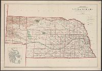
- Description:
- Includes inset of "City of Omaha.", Relief shown by shading., and Shows railroads, national forests, and military and Indian reservations.
- Publisher:
- Andrew B. Graham Company, lithographers,
- Subject (Geographic):
- Nebraska--Maps
- Subject (Name):
- Bauman, Wm. (William), Berthrong, I. P, and Dinsmore, A. F
- Found in:
- Beinecke Rare Book and Manuscript Library > State of Nebraska / Department of the Interior, General Land Office ; compiled from the official records of the General Land Office and other sources under the direction of I.P. Berthrong ; compiled by A.F. Dinsmore ; traced and lettered by Wm. Bauman, Jr
- Creator:
- United States. General Land Office
- Published / Created:
- 1906
- Call Number:
- 846 1906
- Container / Volume:
- BRBL_00621
- Image Count:
- 1
- Resource Type:
- Maps, Atlases & Globes
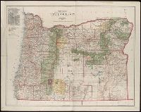
- Abstract:
- Shows county boundaries, military and Indian reservations, forest reserves, national parks, military roads, and lighthouses.
- Description:
- Gives longitude west from Greenwich and Washington, D.C., Inset: City of Portland., and Relief shown by shading.
- Publisher:
- The Office,
- Subject (Geographic):
- Oregon--Maps
- Subject (Name):
- Andrew B. Graham Co, Bauman, Wm. (William), Bond, Frank, 1856-1940, Dinsmore, A. F, and Hendges, M
- Found in:
- Beinecke Rare Book and Manuscript Library > State of Oregon / compiled from the official records of the General Land Office and other sources under the direction of Frank Bond ; compiled by M. Hendges ; revised by A.F. Dinsmore ; traced and lettered by Wm. Bauman Jr.
- Creator:
- United States. General Land Office
- Published / Created:
- 1905
- Call Number:
- 847 1905
- Container / Volume:
- BRBL_00625
- Image Count:
- 1
- Resource Type:
- Maps, Atlases & Globes
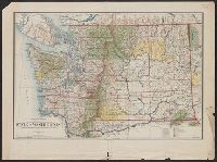
- Description:
- Includes township diagram., Prime meridians: Greenwich and Washington., and Relief shown by shading and spot heights.
- Publisher:
- General Land Office,
- Subject (Geographic):
- Washington (State)--Maps
- Subject (Name):
- Bauman, Wm. (William) and O'Hare, Daniel
- Found in:
- Beinecke Rare Book and Manuscript Library > State of Washington / compiled from the official records of the General Land Office and other sources, under the direction of Frank Bond, chief of drafting division, G.L.O. ; compiled and drawn by Daniel O'Hare ; lettering by Wm. Bauman jr.