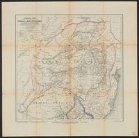
Transvaal or South-African Republic, including the gold and diamondfields
Description:
"From the best sources and documents, especially from sourveys [sic] by Mr. Mauch, Baines, Mohr, and others.", Relief shown by hachures., and Shows "boundary of the tsetse fly."
Publisher:
[A. Merensky,
Subject (Geographic):
Transvaal (South Africa)--Maps
Subject (Name):
Sulzer, J
Subject (Topic):
Diamond mines and mining--South Africa--Transvaal--Maps, Gold mines and mining--South Africa--Transvaal--Maps, and Tsetse-flies--South Africa--Transvaal--Maps
Carte de la partie occidentale de l 'Asie mineure and Map of the western part of Asia Minor
Description:
Covers western Anatolia and islands in Aegean Sea., Map in German; title in German, French, and English., Relief shown by shading and spot heights., and Sheet XV. only
Publisher:
Verlag von Dietrich Reimer,
Subject (Geographic):
Aegean Islands (Greece and Turkey)--Maps and Turkey--Maps
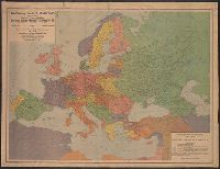
"Berliner Lithographisches, Institut Julius Moser.", "Supplement no. 2, January issue, 1921, 'The Transatlantic Trade, ' published by the American Chamber of Commerce, Berlin.", and "The boundaries of Germany, German-Austria, Bulgaria and Turkey have been adjus
Publisher:
GEA Verlag, Berlin,
Subject (Geographic):
Europe--Maps and Germany--Maps
Subject (Name):
American Chamber of Commerce in Germany and Institut Julius Moser