
You Searched For
1 - 5 of 5
Search Results
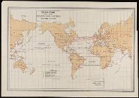
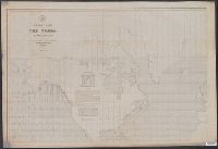
2.
- Creator:
- United States. Hydrographic Office
- Published / Created:
- Sep., 1914 [that is, 1916]
- Call Number:
- BrSides Elephant Folio 2018 22
- Image Count:
- 1
- Resource Type:
- Maps, Atlases & Globes
- Description:
- "No. 1262.", "Small corrections from notices to mariners ('15-2, 18, 30, from other sources I '16.", Includes charts: "Speeds per hour with daily and weekly distances in nautical miles" and "Reduction knots on nautical miles to statute miles." Also includes 4 distance charts., and Relief shown by hachures and spot heights.
- Publisher:
- Published ... at the Hydrographic Office,
- Subject (Topic):
- Steam-navigation--Maps.
- Found in:
- Beinecke Rare Book and Manuscript Library > Tracks for full powered steam vessels with the shortest navigable distances in nautical miles from anchorage to anchorage, New York distances are measures to and from the Battery achorage.
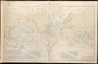
- Creator:
- Maury, Matthew Fontaine, 1806-1873
- Published / Created:
- 1851
- Call Number:
- 11DB 1851A-1
- Container / Volume:
- BRBL_00774
- Image Count:
- 1
- Resource Type:
- Maps, Atlases & Globes
- Alternative Title:
- [Maury map collection ; ser. F1]
- Description:
- DLC, Includes notes., and The whale chart was released as series F a part of Maury's "Wind and current charts", series A-F. For complete discussion, see "The wind and current chart series produced by Matthew Fontaine Maury," by Marc I. Pinsel, in Navigation : J
- Publisher:
- National Observatory,
- Subject (Name):
- Maury, Matthew Fontaine, 1806-1873. Wind and current charts, United States Naval Observatory, United States. Bureau of Ordnance and Hydrography, W. Endicott & Co, and Warrington, L. (Lewis), 1782-1851
- Subject (Topic):
- Right whales--Maps, Sperm whale--Maps, Whales--Maps, and Whaling--Maps
- Found in:
- Beinecke Rare Book and Manuscript Library > Whale chart [cartographic material] : preliminary sketch / by M.F. Maury, A.M. Lieut., U.S. Navy ; constructed by Lts. Leigh. Herndon & Fleming & Pd. Midn. Jackson.
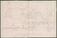
- Creator:
- Maury, Matthew Fontaine, 1806-1873
- Published / Created:
- 1852
- Call Number:
- 11cfk 1850F
- Container / Volume:
- BRBL_00774
- Image Count:
- 4
- Resource Type:
- Maps, Atlases & Globes
- Alternative Title:
- [Maury map collection ; Series F4], Maury's wind & current chart : whale sheet, and Whale sheet
- Description:
- "Series F.", Each sheet numbered in upper left margin, e.g.: 79, 80, 81, 82., and The whale chart was released as series F a part of Maury's "Wind and current charts", series A-F. For complete discussion, see "The wind and current chart series produced by Matth
- Publisher:
- United States Hydrographical Office,
- Subject (Name):
- Maury, Matthew Fontaine, 1806-1873. Wind and current charts, United States. Bureau of Ordnance and Hydrography, and United States. Hydrographic Office
- Subject (Topic):
- Ocean--Maps, Right whales--Maps, Sperm whale--Maps, and Whales--Maps
- Found in:
- Beinecke Rare Book and Manuscript Library > Whale chart of the world [cartographic material] / by M.F. Maury, L.L.D. Lieut. U.S. Navy, superin'dt. of U.S.N. Observatory ; compiled from materials in the Bureau of Ordnance and Hydrography by P.M. A.C. Jackson.
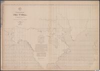
- Creator:
- Maury, Matthew Fontaine, 1806-1873
- Published / Created:
- 1852
- Call Number:
- 11cfk 1850F
- Container / Volume:
- BRBL_00774
- Image Count:
- 4
- Resource Type:
- Maps, Atlases & Globes
- Alternative Title:
- [Maury map collection ; Series F4], Maury's wind & current chart : whale sheet, and Whale sheet
- Description:
- "Series F.", Shows geographical locations of sperm and right whales., and The whale chart was released as series F a part of Maury's "Wind and current charts", series A-F. For complete discussion, see "The wind and current chart series produced by Matthew Fonta
- Publisher:
- United States Hydrographical Office,
- Subject (Name):
- Maury, Matthew Fontaine, 1806-1873. Wind and current charts, United States. Bureau of Ordnance and Hydrography, and United States. Hydrographic Office
- Subject (Topic):
- Ocean--Maps, Right whales--Maps, Sperm whale--Maps, and Whales--Maps
- Found in:
- Beinecke Rare Book and Manuscript Library > Whale chart of the world [cartographic material] / by M.F. Maury, L.L.D. Lieut. U.S. Navy, superin'dt. of U.S.N. Observatory ; compiled from materials in the Bureau of Ordnance and Hydrography by P.M. A.C. Jackson.