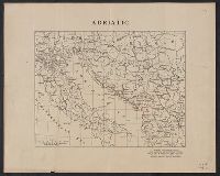
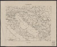
Russian S.F.S.R. Narodnyĭ komissariat vnutrennikh del Russian S.F.S.R. Народный комиссариат внутренних дел
Published / Created:
1930]
Call Number:
352 1930B
Container / Volume:
BRBL_00106
Image Count:
2
Resource Type:
Maps, Atlases & Globes
Alternative Title:
Административная карта европеиской частьи С.С.С.Р. / составлена и издана Kартоиздательством Н.К.В.Д. Р.С.Ф.С.Р.
Description:
"Glavlit No. A-52827.", "Granit︠s︡y na 1-e i︠a︡nvari︠a︡ 1930 g.", "Vypusk 2/24.", "Выпуск 2/24.", "Главлит No. А-52827.", "Границы на 1-е января 1930 г.", and 352 1930B: Imperfect: Mutilated with loss of text.
Publisher:
Kartoizdatelʹstvo N.K.V.D. R.S.F.S.R., and Kартоиздательство Н.К.В.Д. Р.С.Ф.С.Р.,
Subject (Geographic):
Soviet Union, Western--Administrative and political divisions--Maps
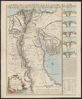
New England: the most remarqueable parts thus named by the high and mighty Prince Charles, nowe King of great Britaine [map] and Path-way to experience to erect a plantation.
Description:
Imperfect: damp-stained; added port. of Charles I., Map with portrait of Capt. Smith in corner: New England ... / observed and described by Captayn John Smith. 1614. Pendleton's Lithography, Boston. Drawn by J. Eddy. London, printed by Geor: Low., Signatures: A-F⁴., and Teaching resource: Professor John Mack Faragher, History 141: The American West.
Publisher:
Printed by I. Haviland, and are to be sold by R. Milbovrne,
Subject (Geographic):
Massachusetts--History--Colonial period, ca. 1600-1775, Massachusetts--Maps--Early works to 1800, New England--Description and travel, New England--History--Colonial period, ca. 1600-1775, and New England--Maps--Early works to 1800