Skip to search
Skip to main content
Skip to first result
Search
You Searched For
Genre
Maps
Genre
Maps in books
Language
Latin
New Search
Search Results
Creator:
Published / Created:
ca. 1730?
Call Number:
1975 Folio 31
Collection Title:
[Atlas factice of 42 maps, produced by the Homann Erben firm]
Image Count:
2
Alternative Title:
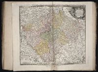
Bohemiae Regnum in duodecim Circulos divisum and Royaume de Boheme divise en XII cercles
Publisher:
Homann Erbe
Subject (Geographic):
Bohemia (Czech Republic) --Maps --Early works to 1800
Subject (Topic):
Atlases, German --Early works to 1800
Collection Created:
[Nuremberg,
Found in:
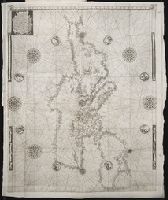
Beinecke Rare Book and Manuscript Library > Bohemiae Regnum in XII Circulos divisum [cartographic material] : cum Com. Glac. et Distr. Egerano ceterisq[ue] circumjacentibiis terris / ex Muellerianis aliisq[ue] chorographicis subsidys delineatum nunc noviter revisum et emendatius per Homannianos Her
Creator:
Published / Created:
[ca. 1730?]
Call Number:
1983 Folio 23
Collection Title:
[Atlas factice of 50 maps, primarily by Johann Baptist Homann and/or issued by the Homann Erben
Image Count:
1
Alternative Title:
Bohemiae Regnum in duodecim Circulos divisum and Royaume de Boheme divise en XII cercles
Publisher:
[Homann Erben]
Subject (Geographic):
Bohemia (Czech Republic) --Maps --Early works to 1800
Collection Created:
[Nuremberg : Homann Erben, 1710-1786]
Found in:
Beinecke Rare Book and Manuscript Library > Bohemiae Regnum in XII Circulos divisum [cartographic material] : cum Com. Glac. et Distr. Egerano ceterisq[ue] circumjacentibiis terris / ex Muellerianis aliisq[ue] chorographicis subsidys delineatum nunc noviter revisum et emendatum per Homannianos Here
Creator:
Published / Created:
1780
Call Number:
1983 Folio 23
Collection Title:
[Atlas factice of 50 maps, primarily by Johann Baptist Homann and/or issued by the Homann Erben
Image Count:
1
Publisher:
Impensis Heredum Homannianorum
Subject (Geographic):
Prussia, West (Poland) --Maps --Early works to 1800
Collection Created:
[Nuremberg : Homann Erben, 1710-1786]
Found in:
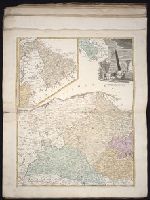
Beinecke Rare Book and Manuscript Library > Borussiae occidentalis tabula [cartographic material] / a Franc. Ludov. Guessefeld
Published / Created:
[Ca. 1612]
Call Number:
Pequot G325
Collection Title:
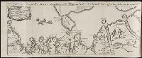
Descriptio ac delineatio geographica detectionis freti, sive, transitus ad occasum supra terras
Image Count:
1
Description:
Bound in after p. [26]. and Scale not given.
Subject (Geographic):
Barents Sea --Maps --Early works to 1800 and Siberia (Russia) --Maps
Collection Created:
Amsterodami Ex officina Hesse lij Gerardi. Anno 1613
Found in:
Beinecke Rare Book and Manuscript Library > Caerte van’t noorderste Russen, Samojeden, ende Tingoesen landt ...
Published / Created:
[Ca. 1612]
Call Number:
Taylor 258
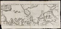
Collection Title:
Descriptio ac delineatio geographica detectionis freti, sive, transitus ad occasum supra terras
Image Count:
1
Alternative Title:
Caerte van’t noorderste Russen, Samojeden, ende Tingoesen landt
Description:
Bound in after p. [30]., Description of Siberia by Isaac Abrahamszoon Massa., Map cut and folded irregularly., Map has multiple small ink stains on verso at the top., Printed on recto in lower right corner: D3., and Scale not given.
Subject (Geographic):
Barents Sea --Maps --Early works to 1800
Subject (Name):
Massa, Isaac, 1587-1635
Collection Created:
Amsterodami Ex officina Hesse lij Gerardi. Anno 1613
Found in:
Beinecke Rare Book and Manuscript Library > Caerte van’t noorderste Russen, Samojeden, ende Tingoesen landt : alsoo dat vand Russen afghetekent, en door Isaac Massa vertaelt is
Creator:
Published / Created:
1743
Call Number:
1975 Folio 31
Collection Title:
[Atlas factice of 42 maps, produced by the Homann Erben firm]
Image Count:
1
Alternative Title:
Staat von der Republic Genova, nach seiner Eintheilung in die ost- u. west-Revier
Publisher:
Homann Erben
Subject (Geographic):
Genoa (Italy) --Maps --Early works to 1800
Subject (Topic):
Atlases, German --Early works to 1800
Collection Created:
[Nuremberg,
Found in:
Beinecke Rare Book and Manuscript Library > Carta Geographica, la quale rappresenta lo Stato della Republica di Genova partita nella Riviera di Levante et di Ponente / [cartographic material] / data in publico per gli Heredi d'Homann ; con privil. imp le 1743 = Staat von der Republic Genova, nach s
Creator:
Published / Created:
1596
Call Number:
Taylor 224
Collection Title:
Navtica mediterranea / di Bartolomeo Crescentio Romano ... Nella quale si mostra la fabrica delle
Image Count:
1
Description:
Map bound in at end., Map cut and folded irregularly., Map done on two separate sheets and pasted together in center., Map has several small gray and black smudges on both the recto and verso that appear to be fingerprints left during the engraving process., Map has several small yellow and brown marks, most notably on verso, although one can be seen on recto in lower right section., and Scale [ca. 1:6,500,000].
Subject (Geographic):
Mediterranean Region --Maps --Early works to 1800 and Mediterranean Sea --Navigation --Early works to 1800
Subject (Topic):
Galleys --Early works to 1800, Navigation --Early works to 1800, and Pilot guides --Mediterranean Sea --Early works to 1800
Collection Created:
Roma : Appresso Bartolomeo Bonfadino, 1607
Found in:
Beinecke Rare Book and Manuscript Library > Chartam Mediterraneam antea magna obrutam falsitate ...
Creator:
Published / Created:
ao. 1761
Call Number:
1983 Folio 23
Collection Title:
[Atlas factice of 50 maps, primarily by Johann Baptist Homann and/or issued by the Homann Erben
Image Count:
1
Publisher:
Edita sumtibus Homannianorum Heredum
Subject (Geographic):
Bremen (Germany : Duchy) --Maps --Early works to 1800, Hannover (Germany : Province) --Maps --Early works to 1800, Lower Saxony (Germany) --Maps --Early works to 1800, and Westphalia (Germany) --Maps --Early works to 1800
Collection Created:
[Nuremberg : Homann Erben, 1710-1786]
Found in:
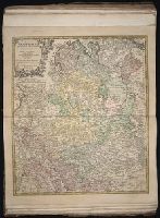
Beinecke Rare Book and Manuscript Library > Circuli Westphaliae [cartographic material]: quoad partem septentrionalem in suos Status ecclesiasticos & seculares divisi tabula geographica
Creator:
Published / Created:
1734
Call Number:
1975 Folio 31
Collection Title:
[Atlas factice of 42 maps, produced by the Homann Erben firm]
Image Count:
1
Publisher:
Homann Erben
Subject (Geographic):
Saxony (Germany) --Maps --Early works to 1800
Subject (Topic):
Atlases, German --Early works to 1800
Collection Created:
[Nuremberg,
Found in:
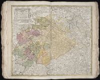
Beinecke Rare Book and Manuscript Library > Circuli supe. Saxoniae pars meridionalis [cartographic material] : sive ducatus, electoratus et principatus Ducum Saxoniae / ex Zolmannianis et Zuernerianis subsidijs designata et edita per Homannianos Heredes
Creator:
Published / Created:
1757
Call Number:
1973 Folio 30
Collection Title:
[Atlas factice of 32 maps and 1 distance table, produced by the Homann Erben firm]
Image Count:
2
Subject (Geographic):
Saxony (Germany) --Maps --Early works to 1800
Subject (Topic):
Atlases, German --Early works to 1800
Collection Created:
[Nuremberg : s.n., 1701-1760]
Found in:
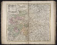
Beinecke Rare Book and Manuscript Library > Circuli supe. Saxoniae pars meridionalis sive Ducatus, Electoratus et Principatus Ducum Saxoniae / [cartographic material] / ex Zolmannianis et Zuå¬rnerianis subsidijs designata et edita per Homannianos Heredes
Branch:v1.61.8 ,Deployed:2024-06-20T11:15:04-04:00