
You Searched For
1 - 10 of 10
Search Results

2.

- Creator:
- Lotter, Tobias Conrad, 1717-1777
Seutter, Matthaeus, 1678-1756 - Published / Created:
- 1750
- Call Number:
- 1973 Folio 30
- Collection Title:
- [Atlas factice of 32 maps and 1 distance table, produced by the Homann Erben firm]
- Image Count:
- 2
- Publisher:
- [Matthaeus Seutter?]
- Subject (Geographic):
- Saxony-Anhalt (Germany) --Maps --Early works to 1800
- Subject (Topic):
- Atlases, German --Early works to 1800
- Collection Created:
- [Nuremberg : s.n., 1701-1760]
- Found in:
- Beinecke Rare Book and Manuscript Library > Delineatio geographica comitatus Mansfeldensis ad jurisdictionem tum Saxonicam tum Brandenburgicam spectans, cum praefectura Sangerhusana, Querfurtensi, Sittenbacensi, Allstaedensi, et loci finitimis / [cartographic material] / cura Matth. Seutteri, Geogr
3.

- Creator:
- Lotter, Tobias Conrad, 1717-1777
Seutter, Matthaeus, 1678-1756 - Published / Created:
- 1758
- Call Number:
- 1973 Folio 30
- Collection Title:
- [Atlas factice of 32 maps and 1 distance table, produced by the Homann Erben firm]
- Image Count:
- 2
- Publisher:
- [Tobias Conrad Lotter]
- Subject (Geographic):
- Halle (Germany : Regierungsbezirk) --Maps --Early works to 1800 and Magdeburg (Germany : Regierungsbezirk) --Maps --Early works to 1800
- Subject (Topic):
- Atlases, German --Early works to 1800
- Collection Created:
- [Nuremberg : s.n., 1701-1760]
- Found in:
- Beinecke Rare Book and Manuscript Library > Ducatus Magdeburgensis et Halensis cum finitimis delineation geographica / [cartographic material] / curante Matthaeo Seuttero, Geographo. Caeser
4.

- Creator:
- Lotter, Tobias Conrad, 1717-1777
Seutter, Matthaeus, 1678-1756 - Published / Created:
- ca. 1750
- Call Number:
- 1973 Folio 30
- Collection Title:
- [Atlas factice of 32 maps and 1 distance table, produced by the Homann Erben firm]
- Image Count:
- 2
- Publisher:
- [Tobias Conrad Lotter?]
- Subject (Geographic):
- Chemnitz (Germany : Landkreis) --Maps --Early works to 1800 and Zwickau (Germany : Landkreis) --Maps --Early works to 1800
- Subject (Topic):
- Atlases, German --Early works to 1800
- Collection Created:
- [Nuremberg : s.n., 1701-1760]
- Found in:
- Beinecke Rare Book and Manuscript Library > Dynastiae comitat[us] Schoenbuirgici Penig, Remissa, Rochsburg, Wechselburg [cartographic material] : in clientela Elect. Saxon Glaucha, Hartenstein, Lichtenst. Stein, Waldenburg Praedia Benefic. S.R. Imp. ad circulum S.R.I. Saxoniae superiorem pertinente

- Creator:
- Lotter, Tobias Conrad, 1717-1777
Seutter, Matthaeus, 1678-1756 - Published / Created:
- ca. 1757
- Call Number:
- 1973 Folio 30
- Collection Title:
- [Atlas factice of 32 maps and 1 distance table, produced by the Homann Erben firm]
- Image Count:
- 2
- Publisher:
- [Tobias Conrad Lotter]
- Subject (Geographic):
- Saxony (Germany) --Maps --Early works to 1800
- Subject (Topic):
- Atlases, German --Early works to 1800
- Collection Created:
- [Nuremberg : s.n., 1701-1760]
- Found in:
- Beinecke Rare Book and Manuscript Library > Electoratus Saxonici Praefecturae Annaburgensis, Pretzschens[is] Torgaviensis, Schweinicensis, Muehlbergensis studio geographico / [cartographic material] / ita depictae, ut urbes, oppida, vici, pagi, aedes solitar cum vicinia accurate distingui possint a

- Creator:
- Lotter, Tobias Conrad, 1717-1777
Seutter, Matthaeus, 1678-1756 - Published / Created:
- [ca. 1758]
- Call Number:
- 1973 Folio 30
- Collection Title:
- [Atlas factice of 32 maps and 1 distance table, produced by the Homann Erben firm]
- Image Count:
- 2
- Publisher:
- Anjezo im Verlag bey Tobias Conrad Lotter, Geogr. ...
- Subject (Geographic):
- Saxony-Anhalt (Germany) --Maps --Early works to 1800
- Subject (Topic):
- Atlases, German --Early works to 1800
- Collection Created:
- [Nuremberg : s.n., 1701-1760]
- Found in:
- Beinecke Rare Book and Manuscript Library > Episcopatus Numburgensis et cizensis delineatio geographica adjectis praefecturis Portensi, Pegaviensi, Tautenburg et finitimis / [cartographic material] / cura Matth. Seutteri Geogr. Caes
7.
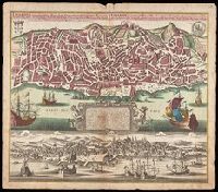
- Creator:
- Seutter, Matthaeus, 1678-1756
- Published / Created:
- [1735]
- Call Number:
- BrSides Double Folio 2019 47
- Image Count:
- 1
- Resource Type:
- Maps, Atlases & Globes
- Alternative Title:
- Lisabon die prächtigste Königl. Residenz Statt in Portugall u. florisanteste Handels Plaz am Austfluss des Tagi
- Description:
- "Cum gratia et privil. S.R.I. Vicariatus in partibus Rheni, Suevice, et Juris Franconici.", Historiated cartouche with note., Includes aerial view of "Lisabon" at bottom., and Manuscript number in upper right corner. From the Karpinski-von Wieser Map Collection.
- Publisher:
- [Matthaeus Seutter]
- Subject (Geographic):
- Lisbon (Portugal)--Aerial views--Early works to 1800, Lisbon (Portugal)--Maps--Early works to 1800, and Portugal--Lisbon
- Found in:
- Beinecke Rare Book and Manuscript Library > Lisabona magnificentissima Regia sedes Portugalliae et florentissimum Emorium ad oftia tagi situm / aeri incisium per Matth. Seutter S. Cæs. et Reg. Cathol. Maj. Geogr. Aug. Vindel. = Lisabon die prächtigste Königl. Residenz Statt in Portugall u. floris

- Creator:
- Seutter, Matthaeus, 1678-1756
- Published / Created:
- [1730?]
- Call Number:
- 1an 1730
- Image Count:
- 1
- Resource Type:
- Maps, Atlases & Globes
- Alternative Title:
- Charte worauf in einem Begriff und Anblick alle natürliche politische und Kunst-termini oder Wörter benen̄et.
- Description:
- 1an, Demonstrates cartographic terms, symbols, depictions of landforms, etc., Has watermark., Relief shown pictorially., and Title in upper margin: Charte worauf in einem Begriff und Anblick alle natürliche politische und Kunst-termini oder Wörter benen̄et ...
- Publisher:
- Matthaeo Seutter,
- Subject (Topic):
- Cartography--Germany, Cartography--Methodology--Maps, Imaginary places--Maps--Early works to 1800, Maps--Symbols, and Maps--Terminology
- Found in:
- Beinecke Rare Book and Manuscript Library > Mappa geographiae naturalis sive tabella synoptica / inventa et adornata à Matth. Seuttero. S. Caes. Maj. geogr. Aug.

- Creator:
- Seutter, Matthaeus, 1678-1756
- Published / Created:
- 1730?]
- Call Number:
- 352 Sa25 1730
- Container / Volume:
- BRBL_00108
- Image Count:
- 1
- Resource Type:
- Maps, Atlases & Globes
- Alternative Title:
- Abbildung der neuen russischen Haupt-Residenz und See Statt St. Petersburg., Neue Abbildung von der Situation der Statt St. Petersburg., and Neue u: accurate Abbildung der von dem grossen russ. Kaiser Petro Alexiewiz ao. 1703 an dem Aussfl. dess Neva Stroms erb
- Description:
- Abbildung der neuen russischen Haupt-Residenz und See Statt St. Petersburg -- Neue Abbildung von der Situation der Statt St. Petersburg., Includes text, index to selected buildings, and decorative cartouches., Latin and German., and Relief shown pictorially.
- Publisher:
- M. Seutter,
- Subject (Geographic):
- Neva River Watershed (Russia)--Maps--Early works to 1800, Saint Petersburg (Russia)--Maps--Early works to 1800, and Saint Petersburg Region (Russia)--Maps--Early works to 1800
- Found in:
- Beinecke Rare Book and Manuscript Library > Nova et accuratissima urbis St. Petersburg à russorum imperatore Petro Alexiewiz ao. 1703 ad ostium Nevae Fl. conditae et regionis circumjacentis / delineatio per Matth. Seutter, chalc. August. = Neue u: accurate Abbildung der von dem grossen russ. Kaise
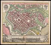
- Creator:
- Seutter, Matthaeus, 1678-1756
- Published / Created:
- [approximately 1752]
- Call Number:
- BrSides Double Folio 2019 20
- Image Count:
- 1
- Resource Type:
- Maps, Atlases & Globes
- Alternative Title:
- Breslau die uhralte u[nd] hochberühmte Haupt Statt des Herzogth. Schlesien auch vortrefflicher aufenthalt der Musen u[nd] florisanter Handels Plaz an dem Oder Strom
- Description:
- "Cum gratia et privil. S.R.I. Vicariat[us] in partib[us] Rheni, Svevice, et Juris Franconici.", Ancillary view: Breslaw. Not drawn to scale., Buildings shown pictorially., Includes index, text, and illustrations., Latin and German., and Manuscript notation in upper right corner. From the Karpinski-von Wieser Map Collection.
- Publisher:
- [Matthaeus Seutter]
- Subject (Geographic):
- Poland--Wrocław, Wrocław (Poland)--Aerial views--Early works to 1800., and Wrocław (Poland)--Maps--Early works to 1800.
- Found in:
- Beinecke Rare Book and Manuscript Library > Wratislavia antiquissima et celeberrima Ducat. Silesiaci metropolis ac florentissimum bonarum artium et mercium emporium ad amnem viadrum = Breslau die uhralte u[nd] hochberühmte Haupt Statt des Herzogth. Schlesien auch vortrefflicher aufenthalt der Muse