Skip to search
Skip to main content
Skip to first result
Search
You Searched For
Repository
Beinecke Rare Book and Manuscript Library
Genre
Engravings
New Search
Search Results
Published / Created:
1850
Call Number:
1976 Folio 96
Collection Title:
A new universal atlas containing maps of the various empires, kingdoms, states and republics of the
Image Count:
1
Resource Type:
Maps, Atlases & Globes
Publisher:
Thomas, Cowperthwait & Co
Subject (Geographic):
Maine
Collection Created:
Philadelphia, Cowperthwait, DeSilver & Butler, 1854, c1850
Found in:
Beinecke Rare Book and Manuscript Library > A new map of Maine
Call Number:
1976 Folio 94
Collection Title:
A new universal atlas containing maps of the various empires, kingdoms, states and republics of the
Image Count:
1
Resource Type:
Maps, Atlases & Globes
Subject (Geographic):
Maine
Collection Created:
Philadelphia, S.A. Mitchell, 1849
Found in:
Beinecke Rare Book and Manuscript Library > A new map of Maine
Call Number:
1976 1233
Collection Title:
Forty-two new maps of Asia, Africa, and America ... : all engrav’d, according to the latest
Image Count:
1
Alternative Title:
Newfoundland, New Scotland, &c
Description:
In pencil on verso: 38. and Table of contents for maps 2-20 in section "America" misnumbered.
Subject (Geographic):
New Brunswick --Maps, Newfoundland --Maps --Early works to 1800, and Nova Scotia --Maps --Early works to 1800
Subject (Name):
Nicholson, John, d. ca. 1717, bookseller
Subject (Topic):
Atlases --Early works to 1800
Collection Created:
London : Printed for J. Nicholson ..., 1716 ...
Found in:
Beinecke Rare Book and Manuscript Library > A new map of Newfound land, New Scotland the isles of Breton, Anticoste, St, Iohns &c. together with the fishing bancks
Creator:
Published / Created:
1775 September
Call Number:
A89 P384
Collection Title:
The Pennsylvania magazine: or, American monthly museum
Image Count:
1
Resource Type:
Books, Journals & Pamphlets
Description:
Verso blank.
Subject (Name):
Paine, Thomas, 1737-1809
Collection Created:
Philadelphia, Printed and sold by R. Aitken [1775-1776]
Found in:
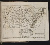
Beinecke Rare Book and Manuscript Library > A new map of North & South Carolina, & Georgia
Call Number:
1976 1233
Collection Title:
Forty-two new maps of Asia, Africa, and America ... : all engrav’d, according to the latest
Image Count:
1
Alternative Title:
North America
Description:
In pencil on verso: 34. and Table of contents for maps 2-20 in section "America" misnumbered.
Subject (Geographic):
North America --Maps --Early works to 1800
Subject (Name):
Nicholson, John, d. ca. 1717, bookseller
Subject (Topic):
Atlases --Early works to 1800
Collection Created:
London : Printed for J. Nicholson ..., 1716 ...
Found in:
Beinecke Rare Book and Manuscript Library > A new map of North America according to the newest observations
Call Number:
1976 1233
Collection Title:
Forty-two new maps of Asia, Africa, and America ... : all engrav’d, according to the latest
Image Count:
1
Alternative Title:
Virginia and Maryland
Description:
In pencil on verso: 41. and Table of contents for maps 2-20 in section "America" misnumbered.
Subject (Geographic):
Maryland --Maps --Early works to 1800 and Virginia --Maps --Early works to 1800
Subject (Name):
Nicholson, John, d. ca. 1717, bookseller
Subject (Topic):
Atlases --Early works to 1800
Collection Created:
London : Printed for J. Nicholson ..., 1716 ...
Found in:
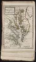
Beinecke Rare Book and Manuscript Library > A new map of Virginia, and Maryland
Call Number:
1977 +379
Collection Title:
Geografia; cioe, Descrittione vniversale della terra. Partita in due volumi, nel primo de' quali si
Image Count:
1
Alternative Title:
[Geographia. Italian]
Subject (Geographic):
Africa. and Guinea
Subject (Topic):
Geography
Collection Created:
In Padova, Appresso Paolo, & Francesco Galignani, fratelli, 1620-21 [v.1, 1621]
Found in:
Beinecke Rare Book and Manuscript Library > A new map of that part of Africacalled the coast of Guinea ...
Creator:
Published / Created:
1788 June 24
Call Number:
1982 Folio 10
Image Count:
2
Description:
Also appeared in Faden's [General atlas. London : William Faden, 1811?]., Hand-coloring of political borders differ from 1982 Folio 10, no. 20., No. 20 of 43 maps bound together in composite atlas., No. 21 of 43 maps bound together in composite atlas., Relief shown pictorially., and Scale [ca. 1:2,150,000].
Publisher:
William Faden
Subject (Geographic):
Europe --Maps --Early works to 1800, Germany --Administrative and political divisions --Maps --Early works to 1800, and Germany --Maps --Early works to 1800
Found in:
Beinecke Rare Book and Manuscript Library > A new map of the German empire and the neighbouring states with their principal post roads : originally published by the Royal Academy of Berlin
Creator:
Published / Created:
1789 June 1
Call Number:
1982 Folio 10
Image Count:
1
Description:
Also appeared in Faden's [General atlas. London : William Faden, 1811?]., No. 22 of 43 maps bound together in composite atlas., Relief shown pictorially., and Scale [ca. 1:565,000].
Publisher:
W. Faden
Subject (Geographic):
Germany --Maps --Early works to 1800
Subject (Name):
Brunswick-Luneburg, House of
Found in:
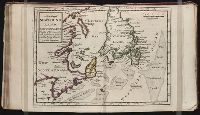
Beinecke Rare Book and Manuscript Library > A new map of the King of Great Britain's dominions in Germany or the electorate of Brunswick-Luneburg and its dependencies
Creator:
Published / Created:
1787 January 1
Call Number:
1982 Folio 10
Image Count:
1
Description:
Also appeared in Kitchin's General atlas describing the whole universe. London : Printed for Robert Sayer, [1780]., Ms. notes in contemporary hand., No. 23 of 43 maps bound together in composite atlas., Relief shown pictorially., Scale [ca. 1:2,450,000]., and Shows vegetation, marshes, etc.
Publisher:
Robert Sayer
Subject (Geographic):
Europe, Eastern --Maps --Early works to 1800, Lithuania --Boundaries --Maps --Early works to 1800, Lithuania --Maps --Early works to 1800, Poland --Boundaries --Maps --Early works to 1800, and Poland --Maps --Early works to 1800
Found in:
Beinecke Rare Book and Manuscript Library > A new map of the Kingdom of Poland with its dismembered provinces
Branch:v1.61.6 ,Deployed:2024-06-12T09:55:31-04:00