First edition, according to Hubbard; A edition, according to Teerink. Small paper issue, and the variation with the misprints "Conspiricies" and "turbulancy" in part 3, p. 90. The portrait is in the first state, with the legend on a tablet under the portrait.
Publisher:
Printed for Benj. Motte, at the Middle Temple-gate in Fleet-street,
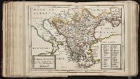
Twenty four new and accurate maps of the several parts of Europe ... : all (except the last) new
Image Count:
1
Alternative Title:
Turkey in Europe
Description:
In pencil on verso: 24. and Table of contents for maps 20-24 misnumbered.
Subject (Geographic):
Turkey --Maps
Subject (Name):
Barker, B. (Benjamin), d. 1764, bookseller, Clements, Henry, d. 1719, bookseller, King, Charles, d. 1735, bookseller, Nicholson, John, d. ca. 1717, bookseller, Parker, Richard, fl. 1692-1725, bookseller, and Tooke, Benjamin, d. 1716, bookseller
Subject (Topic):
Atlases --Early works to 1800
Collection Created:
[London] : Sold by J. Nicholson at the King’s-Arms in Little Britain, Benj. Barker and Charles King ..., Benj. Tooke ..., Hen. Clements ..., R. Parker and Ralph Smith under the Royal-Exchange ..., [1715?]
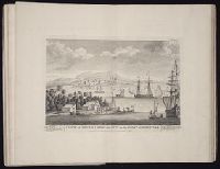
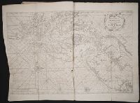
The West-India pilot: containing piloting directions for Port Royal and Kingston harbours in
Image Count:
1
Subject (Geographic):
Atlantic Ocean --Maps --Early works to 1800, Central America --Maps --Early works to 1800, and Honduras --Maps
Subject (Topic):
Harbors --Atlantic Coast (North America) --Maps --Early works to 1800, Nautical charts --Atlantic Coast (North America) --Early works to 1800, Nautical charts --Caribbean Area --Early works to 1800, Nautical charts --West Indies --Early works to 1800, Pilot guides --Atlantic Coast (North America) --Early works to 1800, Pilot guides --Caribbean Area --Early works to 1800, and Pilot guides --West Indies --Early works to 1800
Collection Created:
London : Printed for the author and sold by S. Hooper ..., MDCCLXXI [1771]
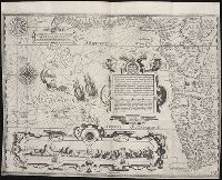
The generall historie of Virginia, New-England, and the Summer Iles : with the names of the
Image Count:
1
Abstract:
Inset depicting Powhatan.
Description:
Between p. 40-41. and Teaching resource: Professor John Mack Faragher, History 141: The American West.
Subject (Geographic):
Virginia --Maps --Early works to 1800
Subject (Topic):
Discoveries in geography, First contact of aboriginal peoples with Westerners, Indians of North America --Virginia --Early works to 1800, and Voyages and travels
Collection Created:
London : Printed by I.[ohn] D.[awson] and I.[ohn] H.[aviland] for Michael Sparkes, 1625
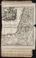
The English pilot: describing the West-India navigation, from Hudson's-Bay to the river Amazones
Image Count:
1
Subject (Geographic):
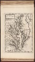
Atlantic Ocean --Maps --Early works to 1800, Chesapeake Bay (Md. and Va.) --Maps --Early works to 1800, Delaware Bay (Del. and N.J.) --Maps --Early works to 1800, Maryland --Maps --Early works to 1800, New Jersey --Maps --Early works to 1800, Pennsylvania --Maps --Early works to 1800, and Virginia --Maps --Early works to 1800
Subject (Topic):
Navigation --Early works to 1800, Pilot guides --Atlantic Coast (U.S.) --Early works to 1800, and Pilot guides --Caribbean Area --Early works to 1800
Collection Created:
London : Printed for W. and J. Mount, T. Page and son, on Tower-Hill, MDCCLX [1760]