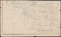
Map of Yakima Region, Washington Ter., western sheet
Description:
"Photolithographed preliminary sheet for the use of the parties in the field, and subject to revision.", In top margin: Western sheet., and Relief shown by contours and spot heights.
Publisher:
Northern Transcontinental Survey?],
Subject (Geographic):
Yakima River Valley (Wash.)--Maps, Topographic
Subject (Name):
Goode, Richard Urquhart, 1858-1903, Julius Bien & Co, Northern Transcontinental Survey, Owen, F. D, and Tweedy, Frank, 1854-1937
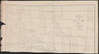
Map of Yakima Region, Washington Ter., eastern sheet
Description:
"Photolithographed preliminary sheet for the use of the parties in the field, and subject to revision.", "There is a slight discordance in projecting the U.S. Land Survey upon this map. A part of the S.W. corner is taken from the U.S. Land Office plats.", and n top margin: Eastern sheet.
Publisher:
Northern Transcontinental Survey?],
Subject (Geographic):
Yakima River Valley (Wash.)--Maps, Topographic
Subject (Name):
Goode, Richard Urquhart, 1858-1903, Julius Bien & Co, Northern Transcontinental Survey, Owen, F. D, and Tweedy, Frank, 1854-1937
1947 map of Yolo County, California and Yolo County map-guide :
Description:
Advertisements, text, ill., and "1947 map of Winters" on verso., At head of title: 1947., Dates on panel: 1947, 1948., Includes advertisements, "Map of the city of Davis, Jan. 1947," and "1947 map of Woodland.", and Library's copy stamped: Triplicate, the Library of Congress duplicate.
"6" and "7" inside right-hand margin., Map removed from unknown atlas., On verso: Statistics of York County, business directories for Biddeford and Saco, Maine., and Stamped on verso: "Yale Univ. Lib. Map Coll. Sep 9 1964".
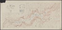
Yosemite Valley, Yosemite National Park, California
Description:
"Surveyed in 1905-1906 in cooperation with the State of California.", At head of title: Department of the Interior., Contour interval 50 feet. Datum is mean sea level., Includes location map and table of "Elevations of principal points.", and Relief shown by contours and spot heights.
Publisher:
U.S. Geological Survey,
Subject (Geographic):
Yosemite Valley (Calif.)--Maps
Subject (Name):
Douglas, Edward Morehouse, 1855-1932, Marshall, R. B. (Robert Bradford), 1867-1949, Matthes, François, 1874-1948, and Urquhart, C. F