[Atlas factice of 50 maps, primarily by Johann Baptist Homann and/or issued by the Homann Erben
Image Count:
1
Alternative Title:
Cours de Danube
Publisher:
Cura Homannianorum Heredum, C.P.S.C.M
Subject (Geographic):
Balkan Peninsula --Maps --Early works to 1800, Danube River Valley --Maps --Early works to 1800, Europe, Central --Maps --Early works to 1800, and Europe, Southern --Maps --Early works to 1800
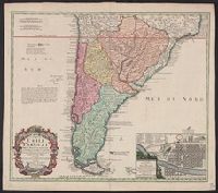
A note on the margin of the map in Latin text gives some historical data and comments upon the climate as being very cold and that the name (Chili) is therefore significan, In Latin and French., Inset: Plan de la ville de Santiago., and Relief shown pictorially.
Publisher:
Editoribus Homannianis Heredibus,
Subject (Geographic):
Santiago (Chile)--Maps--Early works to 1800 and South America--Maps--Early works to 1800
Subject (Name):
Homann Erben (Firm). Atlas geographicus maior and Techo, Nicolás del, 1611-1685
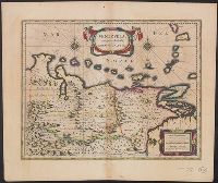
Bar scales in "Milliaria Germanica communia" and "Milliaria Gallica communia.", From Willem and Joan Blaeu's Le theatre du monde ... Amsterdami : Apud Guiljelmum et Iohannem Blaeu, 1635., Relief shown pictorially., and Text in French on verso, with caption title "Venezuela, &c." and signature 7F.
Publisher:
Guiljelmus Blaeuw excudit,
Subject (Geographic):
Venezuela--Maps--Early works to 1800
Subject (Name):
Blaeu, Joan, 1596-1673. Theatrum orbis terrarum. French and Blaeu, Willem Janszoon, 1571-1638. Theatrum orbis terrarum. French