Search
You Searched For
Search Results
- Creator:
- Geological Survey (U.S.)
- Published / Created:
- 1909
- Call Number:
- 844fcm Y83 1909
- Container / Volume:
- BRBL_00615
- Image Count:
- 1
- Resource Type:
- Maps, Atlases & Globes
- Found in:
- Beinecke Rare Book and Manuscript Library > Map of Yosemite Valley, Mariposa County, California / U.S. Geological Survey, George Otis Smith, Director ; E.M. Douglas, geographer ; State of California, George C. Pardee, Govenor.
- Creator:
- Geological Survey (U.S.)
- Published / Created:
- [1918]
- Call Number:
- 844fcm Y83 1918
- Container / Volume:
- BRBL_00615
- Image Count:
- 1
- Resource Type:
- Maps, Atlases & Globes
- Found in:
- Beinecke Rare Book and Manuscript Library > Map of Yosemite Valley, Yosemite National Park, California, Mariposa County / U.S. Geological Survey ; State of California ; E.M. Douglas, geographer ; R.B. Marshall, in charge of section ; topography by F.E. Matthes ; triangulation by C.F. Urquhart.
- Creator:
- Geological Survey (U.S.)
- Published / Created:
- 1917
- Call Number:
- 814 1917
- Container / Volume:
- BRBL_00557
- Image Count:
- 2
- Resource Type:
- Maps, Atlases & Globes
- Found in:
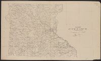
- Beinecke Rare Book and Manuscript Library > State of Minnesota / Department of the Interior, Franklin K. Lane, Secretary, Geological Survey, George Otis Smith, Director ; R.B. Marshall, Chief Geographer ; A.F. Hassan, Cartographer.
- Creator:
- Geological Survey (U.S.)
- Published / Created:
- 1915
- Call Number:
- 834 M56 1915
- Container / Volume:
- BRBL_00589
- Image Count:
- 1
- Resource Type:
- Maps, Atlases & Globes
- Found in:
- Beinecke Rare Book and Manuscript Library > Topographic map of Mesa Verde National Park, Montezuma County, Colorado.
- Creator:
- Geological Survey (U.S.)
- Published / Created:
- 1917
- Call Number:
- BrSides Elephant Folio 2018 24
- Image Count:
- 2
- Resource Type:
- Maps, Atlases & Globes
- Found in:
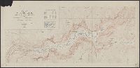
- Beinecke Rare Book and Manuscript Library > Topographic map of the Island of Oahu [cartographic material] : city and county of Honolulu / surveyed 1909-1913 by the Engineer Troops, U.S. Army ; control by U.S. Coast and Geodetic Survey and Hawaiian Territorial Survey ; assembled and drawn by the U.S
- Creator:
- Geological Survey (U.S.)
- Published / Created:
- [1898]
- Call Number:
- 836gfc T498 1898
- Container / Volume:
- BRBL_00593
- Image Count:
- 2
- Resource Type:
- Maps, Atlases & Globes
- Found in:
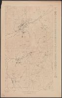
- Beinecke Rare Book and Manuscript Library > Utah : Tintic mining map.