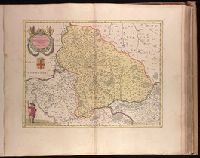
Backed with paper. Illegible ms. note in pencil on map. Ms. no. "55" in upper-right corner. Sheet measures 53.5 x 63.2 cm. No. 50 of 87 maps bound together., Bar scale given in "milliaria Gallica communia"., Prime meridian: Ferro., Relief shown pictorially., Variant with shield below title filled in., and Watermark.
Publisher:
Apud Guiljemum et Joanne[m] Blaeu,
Subject (Geographic):
Île-de-France (France)--Maps--Early works to 1800. and Picardy (France)--Maps--Early works to 1800.
Covers the area from Lake Superior to Kaskaskia and from Delaware Bay to the Mississippi River., Relief shown pictorially., Shows a few towns, missions, forts, Indian villages and tribal territory, rivers and lakes, portages, and early place-names., and Watermark.
Publisher:
[Homann Erben?],
Subject (Geographic):
Canada--Maps--Early works to 1800., Great Lakes Region (North America)--Maps--Early works to 1800., and New France--Maps--Early works to 1800.