Skip to search
Skip to main content
Skip to first result
Search
You Searched For
Genre
Maps
Language
Latin
New Search
Search Results
Published / Created:
[1635?]
Call Number:
3362 1635A
Container / Volume:
BRBL_00088
Image Count:
2
Resource Type:
Maps, Atlases & Globes
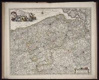
Description:
Preliminary record.
Publisher:
G. Blaeuw,
Subject (Geographic):
East Flanders (Belgium)--Maps--Early works to 1800
Found in:
Beinecke Rare Book and Manuscript Library > Flandria et Zeelandia Comitatus.
Published / Created:
[1650?]
Call Number:
3826 1650
Container / Volume:
BRBL_00176
Image Count:
2
Resource Type:
Maps, Atlases & Globes
Publisher:
Joannis Jassonii,
Subject (Geographic):
Flanders (France)--Maps--Early works to 1800
Found in:
Beinecke Rare Book and Manuscript Library > Flandriae Pars occidentalis ...
Published / Created:
[1635?]
Call Number:
3361 1635
Container / Volume:
BRBL_00088
Image Count:
2
Resource Type:
Maps, Atlases & Globes
Description:
Preliminary record. and Verso: Text.
Publisher:
G. et J. Blaeuw,
Subject (Geographic):
West Flanders (Belgium)--Maps--Early works to 1800
Found in:
Beinecke Rare Book and Manuscript Library > Flandriae Tentonicae pars Orientalior.
Creator:
Published / Created:
ca. 1684
Call Number:
Folio 469
Collection Title:
[Atlas factice of 13 maps by Nicolaes Visscher I, Nicolaes Visscher II, Guillaume Sanson, and
Image Count:
1
Publisher:
Nicolaes Visscher
Subject (Geographic):
Belgium --Maps --Early works to 1800, Europe --Maps --Early works to 1800, and France, Northern --Maps --Early works to 1800
Subject (Topic):
Atlases, Dutch --Early works to 1800
Collection Created:
1677-1692
Found in:
Beinecke Rare Book and Manuscript Library > Flandriae comitatus / [cartographic material] / accuratissima descriptio edita per Nicolaum Visscher
Creator:
Published / Created:
[1700?]
Call Number:
1973 Folio 10
Image Count:
1
Resource Type:
Maps, Atlases & Globes
Description:
Appears in Schenk's Atlas contractus [ca. 1700]., Bar scales in milliaria Germanica communia, milliaria Gallica sive horae itineris, milliaria Italia, and milliaria Anglica., Ferro meridian., Includes decorative vignette in upper left of map., No. 48 of 69 maps bound together in composite atlas., Relief shown pictorially., and Scale [ca. 1:330 000].
Publisher:
[Peter Schenck]
Subject (Geographic):
Belgium --Maps --Early works to 1800 and Flanders --Maps --Early works to 1800
Found in:
Beinecke Rare Book and Manuscript Library > Flandriae comitatus : in suastoparchias optime distinctus, una cum vicinis et finitimis
Published / Created:
[1650?]
Call Number:
3362 1650
Container / Volume:
BRBL_00088
Image Count:
1
Resource Type:
Maps, Atlases & Globes
Description:
Preliminary record.
Subject (Geographic):
East Flanders (Belgium)--Maps--Early works to 1800
Found in:
Beinecke Rare Book and Manuscript Library > Flandriae partes duae ... Apud Janssonio Waesbergios Mosem Pitt et Stephanum Swart.
Published / Created:
[1635?]
Call Number:
3362 1635
Container / Volume:
BRBL_00088
Image Count:
2
Resource Type:
Maps, Atlases & Globes
Description:
Preliminary record. and Verso: Text.
Publisher:
G. et J. Blaeu,
Subject (Geographic):
East Flanders (Belgium)--Maps--Early works to 1800
Found in:
Beinecke Rare Book and Manuscript Library > Flandriae partes duae ... D. Jacobo Wiits ...
Call Number:
Taylor 210
Collection Title:
Chronologicarvm demonstrationvm libri tres. Ioannis Temporarii. Qvorvm primo, temporum series, a
Image Count:
1
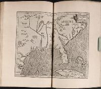
Description:
Between p. 176-177.
Subject (Geographic):
America --Maps --Early works to 1800 and Florida --Maps --Early works to 1800
Subject (Topic):
Chronology and Southern States --Maps --Early works to 1800
Collection Created:
Francofvrti, pud Andreae Wecheli heredes, Claudium Marnium, & ioan. Aubrium, 1596
Found in:
Beinecke Rare Book and Manuscript Library > Florida et Apalche
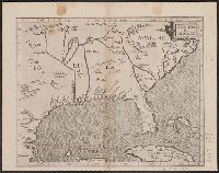
Creator:
Published / Created:
1597]
Call Number:
71 1597
Container / Volume:
BRBL_00725
Image Count:
1
Resource Type:
Maps, Atlases & Globes
Subject (Geographic):
North America--Maps--Early works to 1800
Subject (Name):
Wytfliet, Corneille. Descriptionis Ptolemaicae augmentum
Found in:
Beinecke Rare Book and Manuscript Library > Florida et Apalche [cartographic material].
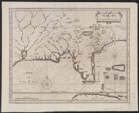
Creator:
Published / Created:
1630]
Call Number:
71 1630
Container / Volume:
BRBL_00725
Image Count:
1
Resource Type:
Maps, Atlases & Globes
Subject (Geographic):
North America--Maps--Early works to 1800
Subject (Name):
Laet, Joannes de, 1581-1649. Nieuwe Wereldt
Found in:
Beinecke Rare Book and Manuscript Library > Florida, et regiones vicinae [cartographic material].
Branch:v1.61.8 ,Deployed:2024-06-20T11:14:55-04:00