Skip to search
Skip to main content
Skip to first result
Search
You Searched For
Format
cartographic
Language
French
Publication Place
[Paris] :
New Search
Search Results
Published / Created:
1916
Call Number:
11hc 1916H
Container / Volume:
BRBL_00010C
Image Count:
1
Resource Type:
Maps, Atlases & Globes
Description:
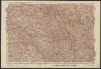
"Front au 1er. Janvier 1916.", "Supplément à l'illustration.", Ms. note outside bottom right margin "L'illus My'19"., and Shows location of Western Front, railways, roads, canals, borders, and fortifications.
Publisher:
G. Peltier,
Subject (Geographic):
France--Maps
Subject (Topic):
World War, 1914-1918--Maps
Found in:
Beinecke Rare Book and Manuscript Library > Le Front de Soissons a Nancy / dressé et dessiné́ par G. Peltier.
Creator:
Published / Created:
1873
Call Number:
38 P21 1873A
Container / Volume:
BRBL_00163
Image Count:
1
Resource Type:
Maps, Atlases & Globes
Description:
Inset: Fortifications et environs de Paris.
Publisher:
Gravé par A. Martin,
Subject (Geographic):
Paris (France)--Maps
Found in:
Beinecke Rare Book and Manuscript Library > Le Plan de Paris de 1873 [cartographic material] / par le dr. Ermète Pierotti.
Published / Created:
[1776?]
Call Number:
32 1767
Container / Volume:
BRBL_00043
Image Count:
1
Resource Type:
Maps, Atlases & Globes
Publisher:
E. hanssard Fecit,
Subject (Geographic):
England--Maps--Early works to 1800
Found in:
Beinecke Rare Book and Manuscript Library > Le Royaume D'Angletere ... Par le Sr. Robert Geographe.
Creator:
Published / Created:
1704
Call Number:
38315 1704
Container / Volume:
BRBL_00177
Image Count:
1
Resource Type:
Maps, Atlases & Globes
Description:
Relief shown pictorially., The zero in date above neat line is missing. Manuscript number on verso, "87.", and Watermark.
Publisher:
[Alexis Hubert Jaillot],
Subject (Geographic):
Meuse (France)--Maps--Early works to 1800.
Found in:
Beinecke Rare Book and Manuscript Library > Le Verdunois ou sont les Prevotez dependans du Balliage de l'Evesché de Verdun et de son Chapitre. : partie du Barrois Ducal, ou Balliage de S. Mihel, dans le Duché de Bar, les Terres Adiacentes du Clermontois, de Stenay, Dun et Iametz &. / par le S. Ia
Creator:
Published / Created:
[1814?]
Call Number:
BrSides Folio 2017 79
Image Count:
1
Resource Type:
Maps, Atlases & Globes
Alternative Title:
Annales des voyages, de la géographie et de l'histoire.
Description:
"Ve. Souscription. Tome II, Cahier III, pag. 395" above neat line., From "Annales des voyages, de la géographie et de l'histoire.", Includes five bar scales., Prime meridian: Paris., Relief shown by hachures., and Watermark.
Publisher:
[François Buisson],
Subject (Geographic):
Denmark--Maps
Subject (Name):
Buisson, François, 1753-1814, Pelicier, A. (Alphonse), and Tardieu, Antoine-François
Found in:
Beinecke Rare Book and Manuscript Library > Le royaume de Danemark : avec une partie de la Súede / par Mr. Lapiel ; Tardieu jeune sculp., Pelicier scrip.
Published / Created:
[1700?]
Call Number:
38hc 1684
Container / Volume:
BRBL_00172
Image Count:
1
Resource Type:
Maps, Atlases & Globes
Publisher:
Chez. l'Autheur. rüe St. André des arts, Porte de Bucy,
Subject (Geographic):
France--Maps--Early works to 1800
Found in:
Beinecke Rare Book and Manuscript Library > Les Attaques de la ville de Gennes et du Fauxbourg de St. Pierre d'Arene. par l'Armeé navale du Roy Commandeépar le Marquis du Quesne, le 24. May 1684. C. Bevey Sculp. A Paris.
Published / Created:
1745
Call Number:
11 1720
Container / Volume:
BRBL_00004
Image Count:
1
Resource Type:
Maps, Atlases & Globes
Description:
"Avec privilege.", Double-hemispherical world map., and Preliminary record.
Publisher:
Ph. Buache ... ,
Subject (Geographic):
World--Maps--Early works to 1800
Subject (Topic):
World maps--Early works to 1800
Found in:
Beinecke Rare Book and Manuscript Library > Mappemond a l'usage du Roy / par Guillaume Delisle ...
Creator:
Published / Created:
[1878?] (
Call Number:
38 P21 1859
Container / Volume:
BRBL_00163
Image Count:
1
Resource Type:
Maps, Atlases & Globes
Description:
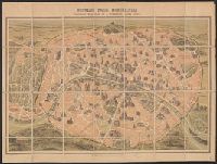
Bird's eye view., Dissected and mounted on linen., DLC, LC copy mounted on cloth., and Selected buildings shown pictorially.
Publisher:
Garnier frères,
Subject (Geographic):
Paris (France)--Buildings, structures, etc.--Maps
Subject (Name):
Dufrénoy (Firm), printer and Garnier frères
Subject (Topic):
Historic buildings--France--Paris--Maps
Found in:
Beinecke Rare Book and Manuscript Library > Nouveau Paris monumental : itinéraire pratique de l'étranger dans Paris / gravé par F. Dufour.
Creator:
Published / Created:
[1878?] (
Call Number:
38AM P21 1867A
Container / Volume:
BRBL_00167
Image Count:
1
Resource Type:
Maps, Atlases & Globes
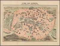
Description:
Bird's eye view., DLC, LC copy mounted on cloth., Mounted on linen., and Selected buildings shown pictorially.
Publisher:
Garnier frères,
Subject (Geographic):
Paris (France)--Buildings, structures, etc.--Maps
Subject (Name):
Dufrénoy (Firm), printer and Garnier frères
Subject (Topic):
Historic buildings--France--Paris--Maps
Found in:
Beinecke Rare Book and Manuscript Library > Nouveau Paris monumental : itinéraire pratique de l'étranger dans Paris / gravé par F. Dufour.
Creator:
Published / Created:
[1878?] (
Call Number:
38AM P21 1867
Container / Volume:
BRBL_00167
Image Count:
1
Resource Type:
Maps, Atlases & Globes
Description:
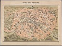
Bird's eye view., DLC, LC copy mounted on cloth., and Selected buildings shown pictorially.
Publisher:
Garnier frères,
Subject (Geographic):
Paris (France)--Buildings, structures, etc.--Maps
Subject (Name):
Dufrénoy (Firm), printer and Garnier frères
Subject (Topic):
Historic buildings--France--Paris--Maps
Found in:
Beinecke Rare Book and Manuscript Library > Nouveau Paris monumental : itinéraire pratique de l'étranger dans Paris / gravé par F. Dufour.
Branch:v1.61.8 ,Deployed:2024-06-20T11:15:15-04:00