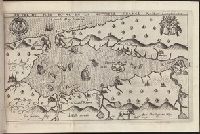
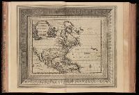
Bound in second after p. [48]., Depicts coat of arms of Henry IV of France and Mary I (Kingdom of Scotland)., Drawn by Marc Lescarbot, engraved by Jan Swelinck, published by I. Millot., Map has some small brown marks that can also be seen on the verso., Scale not given., and Teaching resource: Professor John Mack Faragher, History 141: The American West.
Subject (Geographic):
America --Discovery and exploration --French --Early works to 1800, New France --Discovery and exploration --Early works to 1800, and New France --Maps --Early works to 1800
Subject (Name):
Millot, Jean, b. 1582, printer, Swelinck, Jan, engraver, and Villegaignon, Nicolas Durand de, 1510-1571?
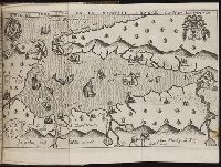
Bound in after p. 440., Depicts coat of arms of Henry IV of France and Mary I (Kingdom of Scotland)., Map has small brown mark on right-most edge that can also be seen on the verso., and Scale not given.
Subject (Geographic):
America --Discovery and exploration --French --Early works to 1800, New France --Discovery and exploration --Early works to 1800, and New France --Maps --Early works to 1800
Subject (Name):
Millot, Jean, b. 1582, printer, Swelinck, Jan, engraver
, and Villegaignon, Nicolas Durand de, 1510-1571?
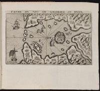
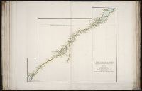
Bound in after p. 190., In pencil in lower left corner on recto: 190., In pencil in lower right corner on recto:262[?]., Map has approximately four small brown marks on the right-most portion that can also be seen on the verso., and Scale not given.
Subject (Geographic):
Guanabara Bay (Brazil) --Maps --Early works to 1800
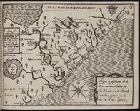
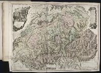
Bound in after p. 64., Depicts coat of arms of Henry IV of France., Map has two small brown marks on the upper left section that can also be seen on the verso., and Scale not given.
Subject (Geographic):
Acadia --Early works to 1800, America --Discovery and exploration --French --Early works to 1800, Florida --Maps --Early works to 1800, New France --Discovery and exploration --Early works to 1800, and New France --Maps --Early works to 1800
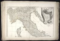
Anville, Jean Baptiste Bourguignon d', 1697-1782 Aveline, J. A. Coypel, Charles-Antoine, 1694-1752
Published / Created:
1743
Call Number:
1982 Folio 10
Image Count:
2
Description:
Also appeared in Anville's [Atlas general. Paris : Jean Baptiste Bourguignon d'Anville, 1771]., Covers also Corsica and Malta., Includes ornamental cartouche drawn and engraved by Coypet and Aveline., No. 17 of 43 maps bound together in composite atlas., Par le Sr. d'Anville ; de la gravure de P. Bourgoin., Relief shown pictorially., and Scale [ca. 1:1,500,000].
"Table generale de l'ordre des feuilles et figures des LXVI tomes": t.1, p. [7]-37. Each section has also special table., 100 copies printed., t. 1. Portugal. -- t. [2-3] Espagne. -- t. 4-9. France. -- t. [10-12] Grande Bretagne & Irlande. --t. [13-16] Les Païs-Bas catholiques. -- t. [17-24] Les VII. Provinces Unies du Païs-Bas. -- t. [25-26] Suisse. -- t. [27-38] Italie. -- t. [39-42] L'empire d'Allemagne. -- t. [43] Danemarc, Norvegue & Suede. -- t. [44] Pologne, Prusse, Courlande, & Moscovie. -- t. [45-47] Hongrie, Turquie en Europe, Gréce, Archipel, Morée &c. -- t. [48-59] Asie. -- t. [60-62] Afrique. -- t. [63-66] Amerique. The prelminary descriptive leaves have continuous signatures., and Title-page in red and black; title vignette.
Publisher:
par Pierre vander Aa
Subject (Topic):
Atlases--Early works to 1800 and Geography--Pictorial works
BEIN 2003 Folio 85: No. 5 of 45 maps bound together with binder's spine title: Atlas of America; ms. table of contents. Bookplate of Paul Mellon., Hand-colored., and Scale ca. 1:700,000.
Subject (Geographic):
Saint Lawrence River -- Maps -- Early works to 1800
Also appeared in Faden's [General atlas. London : William Faden, 1811?]., Includes "Vue de la Vallee de Chamouny et des glaciers du Cote du Midi, prise de l'eglise de Chamouny en 1742," "Section des principales montagnes a l'est-sud-est, et au Sud de Geneve telles qu'on les voit de la plaine de cette ville," descriptive text, illustrated cartouches., No. 19 of 43 maps bound together in composite atlas., Prime meridian: Ferro., Relief shown pictorially., and Scale [ca. 1:404,000].
Haussard, C Robert de Vaugondy, Gilles, 1688-1766, creator
Published / Created:
1755
Call Number:
2003 Folio 85
Image Count:
1
Description:
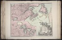
Avec privilege 1755., BEIN 2003 Folio 85: No. 13 of 45 maps bound together with binder's spine title: Atlas of America; ms. table of contents. Bookplate: Robinson. Bookplate of Paul Mellon., C. Haussard sculp., From the author's Atlas universel. 1757[-1758]., Hand colored., Inset of Supplement pour les lacs du Canada. Scale [ca. 1:5,500,000]., par le Sr. Robert de Vaugondy, geog? ordinaire du Roy., Relief shown pictorially., and Scale [ca. 1:4,000,000].
Subject (Geographic):
Canada -- Maps -- Early works to 1800 and New France -- Maps -- Early works to 1800