Histoire de la Nouvelle-France : contenant les navigations, decouvertes, & habitations faites par
Image Count:
1
Description:
Bound in after p. 496., In pencil in upper left corner: 497., Map has three or four small brown marks on verso, the largest of which is on the right margin., and Scale not given.
Subject (Geographic):
America --Discovery and exploration --French --Early works to 1800, New France --Discovery and exploration --Early works to 1800, and New France --Maps --Early works to 1800
Subject (Name):
Millot, Jean, b. 1582, printer, Swelinck, Jan, engraver, and Villegaignon, Nicolas Durand de, 1510-1571?
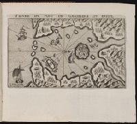
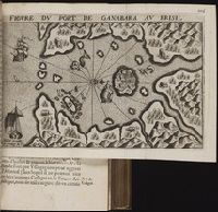
Bound in after p. 190., In pencil in lower left corner on recto: 190., In pencil in lower right corner on recto:262[?]., Map has approximately four small brown marks on the right-most portion that can also be seen on the verso., and Scale not given.
Subject (Geographic):
Guanabara Bay (Brazil) --Maps --Early works to 1800
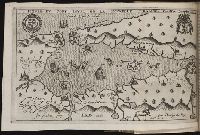
Bound in after p. 64., Depicts coat of arms of Henry IV of France., Map has two small brown marks on the upper left section that can also be seen on the verso., and Scale not given.
Subject (Geographic):
Acadia --Early works to 1800, America --Discovery and exploration --French --Early works to 1800, Florida --Maps --Early works to 1800, New France --Discovery and exploration --Early works to 1800, and New France --Maps --Early works to 1800
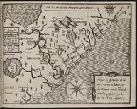
"Atlas universel, Vivien de Saint-Martin & Fr. Schrader." and Relief shown by gradient tints, hachures, and spot heights. Depths shown by bathymetric tints.
Publisher:
Librairie Hachette & compie,
Subject (Geographic):
France--Maps
Subject (Name):
Delaune, E, Dufrénoy (Firm), Dumas-Vorzet, Ed. (Eduard), Hachette (Firm), Schrader, Franz, 1844-1924, Vivien de Saint-Martin, M, and Weinreb, T