Skip to search
Skip to main content
Skip to first result
Search
You Searched For
Format
cartographic
Language
French
New Search
Search Results
Creator:
Published / Created:
[1870]
Call Number:
48 AT42 1863
Container / Volume:
BRBL_00264
Image Count:
1
Resource Type:
Maps, Atlases & Globes
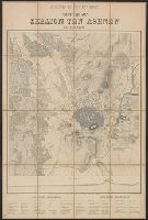
Description:
In French and Greek., Indices on verso., Profile below neat line: Τομὴ κατα α β., Relief shown by hachures., and Title panel on verso.
Publisher:
Imp. Lemercier,
Subject (Geographic):
Athens (Greece)--Maps
Subject (Name):
Erhard (Firm) and Imprimerie Lemercier et cie
Found in:
Beinecke Rare Book and Manuscript Library > Athènes et ses environs [cartographic material] / exécuté par Emmanuel Kalergis, Élève de St. Cyr et de L'École Impériale d'État-Major de France ; gravé chez Erhard.
Published / Created:
1841
Call Number:
36hc 1796
Container / Volume:
BRBL_00133
Image Count:
13
Resource Type:
Maps, Atlases & Globes
Publisher:
Libraire Militaire de J.B. Petit,
Subject (Geographic):
Germany--Maps
Found in:
Beinecke Rare Book and Manuscript Library > Atlas Principes de la Strategie, par S.A.I. Le Prince Chartes, traduit de l'Allemand par le Général Jomini.
Published / Created:
191-.
Call Number:
11hcf 1919A-7
Container / Volume:
BRBL_00010N
Image Count:
2
Resource Type:
Maps, Atlases & Globes
Alternative Title:
Military Operations in Siberia, Inquiry 674
Publisher:
Librarie Armand Colin,
Subject (Geographic):
Siberia, Eastern (Russia)--Maps
Subject (Topic):
World War, 1914-1918--Maps
Found in:
Beinecke Rare Book and Manuscript Library > Atlas Vidal Lablache : Carte politique de l'Asie.
Creator:
Published / Created:
[1894 or 1895]
Call Number:
53 1894
Container / Volume:
BRBL_00285
Image Count:
2
Resource Type:
Maps, Atlases & Globes
Alternative Title:
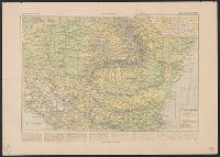
Atlas Vidal Lablanche, États danubiens, and Vient de paraîrte
Description:
Prospectus for the Atlas général Vidal-Lablache; Includes sample map from the Atlas: États danubiens, p. 97a-97b.
Publisher:
Armand Colin & cie,
Subject (Geographic):
Balkan Peninsula--Maps
Subject (Name):
Vidal de La Blache, Paul, 1845-1918
Found in:
Beinecke Rare Book and Manuscript Library > Atlas général Vidal-Lablache, historique et géographique / par M. P. Vidal de la Blache, sous-directeur et maître de conférences à l'École normale supérieure. 420 cartes et cartons en couleur, Index alphabetique de 46,000 mots.
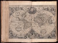
Creator:
Published / Created:
1633
Call Number:
1973 Folio 120
Image Count:
1
Description:
At head of title: Gerardi Mercatoris et I. Hondii., Engraved t.-p., and The paging is irregular, because many maps were inserted with the same page numbering as the preceding map.
Publisher:
Chez Henry Hondius,
Subject (Topic):
Atlases--Early works to 1800
Found in:
Beinecke Rare Book and Manuscript Library > Atlas; ou, Repreísentation du monde vniversel, et des parties d'icilui, faicte en tables et descriptions tres amples et exactes: Diviseí en deux tomes
Published / Created:
1700?]
Call Number:
38 P21 1700A
Container / Volume:
BRBL_00159
Image Count:
1
Resource Type:
Maps, Atlases & Globes
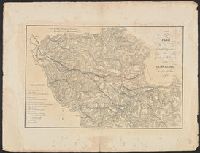
Subject (Geographic):
Paris (France)--Maps--Early works to 1800
Found in:
Beinecke Rare Book and Manuscript Library > Autre vüe Particuliere de Paris depuis Notre Dame jusques au Pont de la Tournelle. au l'ou voit dans l'Eloignement l'hotel de Ville, St. Jean en Greve St. Gervais. Et le pont Rouge. Prise du Quay de Miramion. T. Rigaud Sculp.
Published / Created:
1700?]
Call Number:
38 P21 1700
Container / Volume:
BRBL_00159
Image Count:
1
Resource Type:
Maps, Atlases & Globes
Subject (Geographic):
Paris (France)--Maps--Early works to 1800
Found in:
Beinecke Rare Book and Manuscript Library > Autre vüe particuliere de Paris prise du Milieu du Pónt Neuf regardant vers le Pont Royal. d'ou l'ou coté, le Quai de l'Ecole, Le vieux Louvre, et les galeries dans l'eloignement et de l'autre Conti, Les 4 Nationau etc. Rigaut delieavit et Sculpsit.
Published / Created:
1777
Call Number:
775cea 1777
Container / Volume:
BRBL_00502
Image Count:
2
Resource Type:
Maps, Atlases & Globes
Publisher:
Le Rouge,
Subject (Geographic):
Delaware Bay (Del. and N.J.)--Maps--Early works to 1800
Found in:
Beinecke Rare Book and Manuscript Library > BAye de la Delaware avec les ports, sondes, dangers, bancs, &c, depuis les caps jusqu'a Philadelphie, d'apres la carte de Joshua Fisher publiee a Philadelphie.
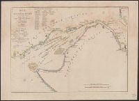
Creator:
Published / Created:
[191-?]
Call Number:
11hcf 1919A-30
Container / Volume:
BRBL_00010N
Image Count:
1
Resource Type:
Maps, Atlases & Globes
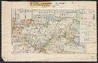
Alternative Title:
Belgrade
Description:
Includes index of adjoining sheets. and Ms. legend along right side of sheet corresponding with ms. notes on map.
Publisher:
Service Géographique de l'Armée,
Subject (Geographic):
Serbia--Maps
Found in:
Beinecke Rare Book and Manuscript Library > Balkans 1 000 000 : Belgrade / dessiné, heliogravé and publié par le Service Géographique de l'Armée.
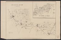
Published / Created:
1859]
Call Number:
40hc 1859J
Container / Volume:
BRBL_00231
Image Count:
1
Resource Type:
Maps, Atlases & Globes
Description:
Inset map: Fatto d'arme di Milazzo, 20 Luglio 1860.
Publisher:
s.n.,
Subject (Geographic):
Italy, Southern--Maps
Found in:
Beinecke Rare Book and Manuscript Library > Battaglia del Volturno.
Branch:v1.61.8 ,Deployed:2024-06-20T11:15:02-04:00