Copper engraving., From Arnoldus Montanus' Ambassades mémorables de la Compagnie des Indes Orientales des Provinces Unies, vers les empereurs du Japon . Amsterdam : Chés Jacob de Meurs, [1680], Index to places of interest., and Panoramic view of Tokyo.
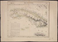
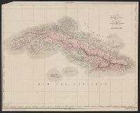
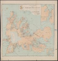
Above neat line: Amér. sep. ... No. 67., Cross Collection no. 279., From Vandermaelen's Atlas universel de géographie physique, politique, statistique et minér, Hand col., Includes text: Ile de Cuba., and Relief shown by hachures.
Publisher:
Philippe Vandermaelen,
Subject (Geographic):
Bahamas--Maps, Cuba--Maps, and Jamaica--Maps
Subject (Name):
Ode, Henri and Vandermaelen, Philippe, 1795-1869. Atlas universel de géographie physique, politique, statistique et minéralogique
From: Atlas national illustre / V. Levasseur., In bottom left margin: Impie. Lemercier, rue de Seine 57 - Paris., In bottom right margin: La geographie gravee par A. Piat., In top right margin: Emisphere Austral no. 88., Insets: Parny -- Bertin., and Map of Reunion showing major rivers. Relief shown by hachures and spot heights.
Publisher:
Chez l'Editeur Rue de la Parcheminerie, 15,
Subject (Geographic):
Réunion--Maps.
Subject (Name):
Lemercier, active 1838-1875., Levasseur, V. (Victor). Atlas national illustre., and Piat, A.
"La géographie. Tome XXXVII.", Insets: Superficie de Kerguelen, comparée à celle de la Corse -- Port Curieuse -- Océan indien., and Relief shown by contours and spot heights. Depths shown by soundings.
Publisher:
Société de géographie,
Subject (Geographic):
Kerguelen Islands--Maps
Subject (Name):
Hansen, Jules, 1849-1931, Loranchet, Jean, Rallier du Baty, Henri, Rallier du Baty, Raymond, 1881-, Saint-Lanne Gramont, Georges, and Société de géographie (France)
Homann Erben (Firm) Homann, Johann Baptist, 1663-1724
Published / Created:
[1746?]
Call Number:
1973 Folio 30
Collection Title:
[Atlas factice of 32 maps and 1 distance table, produced by the Homann Erben firm]
Image Count:
2
Alternative Title:
Allemagne distinguee en ses cercles & subdivisee en ses etats, contenant son etendue presente rectifiee & methodiquement enluminee suivant les elements de geographie de Mr. Schatz and Imperii Romano Germanici in suos status et circulos divisi tabula generalis
Publisher:
[Homann Erben?]
Subject (Geographic):
Austria --Maps --Early works to 1800, Czechoslovakia --Maps --Early works to 1800, Germany --Maps --Early works to 1800, Hungary --Maps --Early works to 1800, and Poland --Maps --Early works to 1800
Homann Erben (Firm) Homann, Johann Baptist, 1663-1724
Published / Created:
ca. 1741
Call Number:
1975 Folio 31
Collection Title:
[Atlas factice of 42 maps, produced by the Homann Erben firm]
Image Count:
2
Alternative Title:
Allemagne distinguee en ses cercles & subdivisee en ses etats, contenant son etendue presente rectifiee & methodiquement enluminee suivant les elements de geographie de Mr. Schatz a 1741 avec privilege imperial and Imperii Romano Germanici in suos status et circulos divisi tabula generalis
Publisher:
Homann Erben?
Subject (Geographic):
Austria --Maps --Early works to 1800, Czechoslovakia --Maps --Early works to 1800, Germany --Maps --Early works to 1800, Hungary --Maps --Early works to 1800, and Poland --Maps --Early works to 1800