Includes population chart and index to ownership of electric railways., Inset: Map showing the lines of communication between New York, Boston and the West., and Relief shown by shading and spot heights.
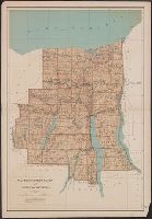
Relief shown by spot heights. and Shows roads, railroads, settlements, original patents, towns, etc.
Publisher:
Julius Bien & Co.,
Subject (Geographic):
Ontario County (N.Y.)--Maps, Seneca County (N.Y.)--Maps, Wayne County (N.Y.)--Maps, and Yates County (N.Y.)--Maps
Subject (Name):
Bien, Joseph R. Atlas of the state of New York, New York : Julius Bien & Co., 1895. pl. 29 and Julius Bien & Co
Subject (Topic):
Land grants--New York (State)--Ontario County--Maps, Land grants--New York (State)--Seneca County--Maps, Land grants--New York (State)--Wayne County--Maps, and Land grants--New York (State)--Yates County--Maps
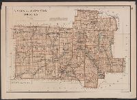
From: Atlas of the state of New York. New York : Julius Bien & Co., 1895., Relief shown by spot heights., and Show roads, railroads, settlements, original patents, towns, etc.
Publisher:
Julius Bien & Co.,
Subject (Geographic):
Livingston County (N.Y.)--Maps and Wyoming County (N.Y.)--Maps
Subject (Name):
Bien, Joseph R. Atlas of the state of New York and Julius Bien & Co
Subject (Topic):
Land grants--New York (State)--Livingston County--Maps and Land grants--New York (State)--Wyoming County--Maps